
America's first transcontinental railroad was a 1,911-mile (3,075 km) continuous railroad line constructed between 1863 and 1869 that connected the existing eastern U.S. rail network at Council Bluffs, Iowa, with the Pacific coast at the Oakland Long Wharf on San Francisco Bay. The rail line was built by three private companies over public lands provided by extensive US land grants. Building was financed by both state and US government subsidy bonds as well as by company-issued mortgage bonds. The Western Pacific Railroad Company built 132 miles (212 km) of track from the road's western terminus at Alameda/Oakland to Sacramento, California. The Central Pacific Railroad Company of California (CPRR) constructed 690 miles (1,110 km) east from Sacramento to Promontory Summit, Utah Territory. The Union Pacific Railroad (UPRR) built 1,085 miles (1,746 km) from the road's eastern terminus at the Missouri River settlements of Council Bluffs and Omaha, Nebraska, westward to Promontory Summit.

Nevada County is a county located in the U.S. state of California, in the Sierra Nevada. As of the 2020 census, its population was 102,241. The county seat is Nevada City. Nevada County comprises the Truckee-Grass Valley micropolitan statistical area, which is also included in the Sacramento-Roseville combined statistical area, part of the Mother Lode Country.

Humboldt County is a county in the U.S. state of Nevada. As of the 2020 Census, the population was 17,285. It is a largely rural county that is sparsely populated with the only major city being Winnemucca which has a population of 8,431. Humboldt County comprises the Winnemucca, NV Micropolitan Statistical Area and serves as an important crossroads in the national transportation network. Interstate 80 travels through the southeastern corner of the county, meeting US 95 in Winnemucca that serves as a primary freight corridor between Northern Nevada and Boise, Idaho and the Interstate 84 freight corridor that links much of the Pacific Northwest. The original transcontinental railway, constructed by the Central Pacific Railroad, reached Humboldt County on Sept. 16, 1868. The Western Pacific Railroad would reach Humboldt County by November 1909, providing two mainline rail links to California and the Eastern United States. Both railroads have since been acquired by the Union Pacific Railroad, who continues to serve the region today.
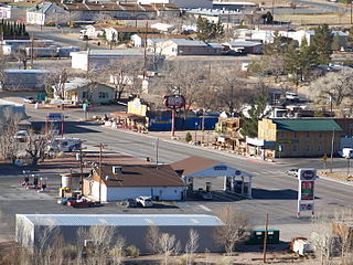
Beatty is an unincorporated town along the Amargosa River in Nye County in the U.S. state of Nevada. U.S. Route 95 runs through the town, which lies between Tonopah, about 90 miles (140 km) to the north and Las Vegas, about 120 miles (190 km) to the southeast. State Route 374 connects Beatty to Death Valley National Park, about 8 miles (13 km) to the west.

The National Register of Historic Places in the United States is a register including buildings, sites, structures, districts, and objects. The Register automatically includes all National Historic Landmarks as well as all historic areas administered by the U.S. National Park Service. Since its introduction in 1966, more than 90,000 separate listings have been added to the register.

Cisco is a ghost town in Grand County, Utah, United States near the junction of State Route 128 (SR‑128) and Interstate 70 (I‑70).
Carp, Nevada is an extinct town in Lincoln County, Nevada, United States located 35 miles (56 km) south of Caliente. It sits on the Meadow Valley Wash, which empties into Lake Mead.

Tie Siding is a tiny unincorporated community in far southeastern Albany County, in southeastern Wyoming, United States, approximately eighteen miles south of Laramie, and eight miles north of the Colorado border. It is located at latitude 41.080N and longitude -105.506W, at an elevation of 7,694 ft. The population is very small, and Tie Siding was not counted as a census-designated place in the 2010 Census.
Johnson Siding is an unincorporated community in Pennington County, South Dakota, United States. The population as of the 2020 census was 614. It is located in the Rimrock Area, approximately 10 miles west of Rapid City. Johnson Siding is surrounded by the Black Hills National Forest. It is the only significant business district in the Rimrock Area, with a gas station/general store, deli, casino, tavern, the Johnson Siding Volunteer Fire Department firehouse, the Rimrock Evangelical Free Church meetinghouse, and a community center. However, most inhabitants work in Rapid City or Deadwood.
The Kamma Mountains are a mountain range in Pershing County and Humboldt County, Nevada. The ghost town and railroad siding at Sulphur, Nevada is on the west side of the Kamma Mountains at the eastern edge of the Black Rock Desert playa.
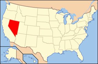
The following is an alphabetical list of articles related to the U.S. State of Nevada.

The Nevada County Narrow Gauge Railroad (NCNGRR) was located in Northern California's Nevada County and Placer County, where it connected with the Central Pacific Railroad. The Nevada County Narrow Gauge Railroad Company incorporated on April 4, 1874, and was headquartered in Grass Valley, California. After two years of construction, passenger and commercial rail services began in 1876 and continued until 1943. The 22.53 mi (36.26 km) line ran from Colfax, north through Grass Valley to Nevada City. At one time, the railroad was notable for having the highest railroad bridge in California, the Bear River Bridge, built in 1908.
Spenceville was a ranching, farming and mining community located in the southwestern part of Nevada County, California, on Spenceville Road just east of Waldo Road, about 17 miles from Grass Valley. Its elevation was about 400 feet. The former townsite is now part of the Spenceville Wildlife Area.
Roach is a ghost town and railroad siding in Clark County, Nevada, United States. It is located along the Union Pacific Railroad, between Jean, Nevada and Nipton, California.

Pequop or Pequop Siding is a ghost town in Elko County, Nevada, United States. It was located west of Toano on the route around the north end of the Pequop Mountains between Cobre and Wells. It was first a stop station of the Central Pacific Railroad and later a non-agency station on the Southern Pacific Railroad. Several buildings were erected to house section crews.

Shafter is a ghost town in Elko County, Nevada, United States.

Moor is a ghost town in Ceder Pass in Elko County, Nevada, United States. It is located along Interstate 80 between Wells and West Wendover.
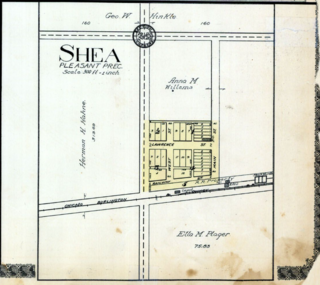
Shea was a small village in Jefferson County, Nebraska, located about four miles west of the town of Diller.
Borax is a ghost town and railroad siding in Clark County, Nevada, United States located along the Union Pacific Railroad east of Interstate 15.
Weso is an unincorporated community and railroad siding in Humboldt County, Nevada, United States located northeast of Winnemucca at the junction of the Winnemucca, Nevada and Elko Subdivisions of the Union Pacific Railroad.


