Related Research Articles

Coleman is a census-designated place and former incorporated city in Randolph County, Georgia, United States. The population was 149 at the 2000 census. The city was abolished by House Bill 1102 effective January 1, 2007, and no longer exists as a municipality.

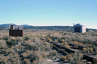
Palisade is located in Eureka County in the northeastern section of the state of Nevada, in the western United States. It is about 10 miles (16 km) south of Carlin, and about 33 miles (53 km) southwest of Elko. Although now a virtual ghost town, it had a rich history following construction of the Transcontinental Railroad. The town takes its name from Palisade Canyon, an important obstacle to the construction and operation of the railroad, which lies to the west.

Tuscarora is an unincorporated community in Elko County, Nevada, United States. The community lies on the east side of the Tuscarora Mountains approximately 40 miles north of Carlin. Tuscarora is part of the Elko Micropolitan Statistical Area. Far from being a ghost town, as several websites proclaim, Tuscarora is home to two schools, a library, a post office and a bar and grill, as well as homes for very much alive residents.

Montello is a census-designated place (CDP) in Elko County, Nevada, United States. It is home to Montello Elementary School, which is part of the Elko County School District. The population of Montello was 50 as of the 2018 American Community Survey. Two small bars and a market/motel selling fuel and sundries comprise the business district. Various cattle ranching operations surround the area.

Carp, Nevada is an extinct town in Lincoln County, Nevada, United States located 35 miles (56 km) south of Caliente. It sits on the Meadow Valley Wash, which empties into Lake Mead.
Cobre is a ghost town in Elko County, Nevada, United States.
Carr is an unincorporated community and U.S. Post Office in Weld County, Colorado, United States. The ZIP Code of the Carr Post Office is 80612. Some consider Carr a ghost town. Today, just a few old houses remain plus the school house and a few old store fronts. Aside from that there are scattered old foundations throughout the town. There are a few year-round residents but for the most part the town is abandoned.
Elgin is a ghost town located between Caliente and Carp, Nevada on the eastern banks of the Meadow Valley Wash off of Nevada State Route 317.

Lee is an unincorporated community in Monon Township, White County, in the U.S. state of Indiana.
Crystal is a former unincorporated community in Clark County, Nevada, United States. It lied along the Union Pacific Railroad and had a population of 10 in 1941. It is now the site of a highway rest stop.
Sodaville is an extinct town in Mineral County, in the U.S. state of Nevada. The GNIS classifies it as a populated place.

The Clover Valley of Nevada, is a 37-mile (60 km) long valley located in central-southeast Elko County. Wells, Nevada lies at its north end, on I-80.

Shafter is a ghost town in Elko County, Nevada, United States.
Sprucemont is a ghost town in Elko County, in the U.S. state of Nevada. The GNIS classifies it as a populated place.

Moor is a ghost town in Ceder Pass in Elko County, Nevada, United States. It is located along Interstate 80 between Wells and West Wendover.
Byron is an extinct town in Clark County, in the U.S. state of Nevada. The community was about 44 miles (71 km) north of Las Vegas.
Fenelon is an extinct town in Elko County, in the U.S. state of Nevada. The GNIS classifies it as a populated place.
Loray is an extinct town in Elko County in Nevada. The GNIS classifies it as a populated place.
Silver Zone is an extinct town in Elko County, in the U.S. state of Nevada. The GNIS classifies it as a populated place. The town was located at the mountain pass where the Feather River Route and Interstate 80 cross the Toano Range.
Tulasco is an extinct town in Elko County, in the U.S. state of Nevada.
References
- 1 2 U.S. Geological Survey Geographic Names Information System: Tobar (historical)
- 1 2 Federal Writers' Project (1941). Origin of Place Names: Nevada (PDF). W.P.A. p. 29.
- ↑ Carlson, Helen S. (1973). Nevada Place Names. p. 232.
- ↑ U.S. Geological Survey Geographic Names Information System: Tobar Post Office
- ↑ "Exploded train continues to burn". Reno Evening Gazette. June 30, 1969. p. 1. Retrieved May 22, 2021.
