North Fork, Nevada

Last updated

North Fork, Nevada
2014-08-19 12 49 32 Abandoned building in North Fork, Nevada.JPG
USA Nevada location map.svg
Red pog.svg
North Fork
Location within the state of Nevada
Coordinates: 41°28′57″N115°49′00″W / 41.48250°N 115.81667°W / 41.48250; -115.81667
Country United States
State Nevada
County Elko
Elevation
6,125 ft (1,867 m)
Time zone UTC-8 (Pacific (PST))
  Summer (DST) UTC-7 (PDT)

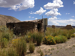
North Fork is an unincorporated community in Elko County, Nevada, United States. [1] The ZIP Code of North Fork, Nevada is 89801.

History

A post office was established at North Fork in 1889, and remained in operation until 1944. [2] A variant name is "Northfork". [1] The community takes its name from nearby North Fork Humboldt River. [3] Due to its small size, some writers classify North Fork as a ghost town. [4]

Related Research Articles

<span class="mw-page-title-main">Delamar, Nevada</span> Ghost town in Nevada, United States

Delamar, Nevada, nicknamed The Widowmaker, is a ghost town in central eastern Nevada, USA along the east side of the Delamar Valley. During its heyday, primarily between 1895 and 1900, it produced $13.5 million in gold.

<span class="mw-page-title-main">Washoe City, Nevada</span> Ghost town in Nevada, United States

Old Washoe City is a ghost town in Washoe County, Nevada, in the United States. Nearby there is a new community called New Washoe City.

<span class="mw-page-title-main">Deeth, Nevada</span> Unincorporated community located in the State of Nevada, United States of America

Deeth is an unincorporated community and census-designated place near the intersection of Interstate 80 and Nevada State Route 230 in Elko County, Nevada, United States.

<span class="mw-page-title-main">Tuscarora, Nevada</span> Unincorporated community in the state of Nevada, United States

Tuscarora is an unincorporated community in Elko County, Nevada, United States. The community lies on the east side of the Tuscarora Mountains approximately 40 miles north of Carlin. Tuscarora is part of the Elko Micropolitan Statistical Area. Far from being a ghost town, as several websites proclaim, Tuscarora is home to two schools, a library, a post office and a bar and grill, as well as homes for its very much alive residents.

<span class="mw-page-title-main">Mountain City, Nevada</span> Census-designated place in Nevada, United States

Mountain City is a small census-designated place in Elko County, Nevada, United States, within the Mountain City Ranger District of the Humboldt-Toiyabe National Forest. The community, located on State Route 225 approximately 16 miles (26 km) south of the Idaho border, is situated on the Owyhee River at an elevation of approximately 5,620 feet (1,710 m).

Lee is an unincorporated community in Elko County, Nevada, United States. The community is located on the reservation land belonging to, and constituting the sole organized community of, the South Fork Band of the Te-Moak Tribe of Western Shoshone Indians of Nevada. Lee is located at the western foothills of the Ruby Mountains range, within the Elko Micropolitan Statistical Area.

Contact is an unincorporated community in Elko County, Nevada, United States. It is located on a mineral-rich granite intrusion and there are many mines nearby.

<span class="mw-page-title-main">San Jacinto, Nevada</span> Ghost town in Nevada, United States

San Jacinto is a ghost town in along Salmon Falls Creek in northern Elko County, Nevada, United States. It is part of the Elko Micropolitan Statistical Area.

<span class="mw-page-title-main">Cobre, Nevada</span> Ghost town in Nevada, United States

Cobre is a ghost town in Elko County, Nevada, United States.

<span class="mw-page-title-main">Sunnyside, Nevada</span> Unincorporated community in the state of Nevada, United States

Sunnyside is a small unincorporated community in the White River Valley of eastern Nevada, near the southern terminus of the Egan Range. The site is located on State Route 318 approximately 31 miles by road south of Lund in White Pine County, the closest town, and 63 miles by road north of Hiko in Lincoln County.

Arthur is an unincorporated community and ghost town in Nevada, United States.

Rowland is a ghost town in northern Elko County, Nevada, United States.

South Fork is an unincorporated community semi-ghost town in Elko County, Nevada in the United States.

<span class="mw-page-title-main">Fairview, Nevada</span> Historic site

Fairview is a ghost town in Churchill County, Nevada, in the United States of America.

<span class="mw-page-title-main">Charleston, Nevada</span> Ghost town in Nevada, United States

Charleston is a ghost town in Elko County, Nevada, United States. It lies along the Bruneau River just south of the Mountain City and Jarbidge Ranger Districts of the Humboldt-Toiyabe National Forest and is near the southwest edge of the Jarbidge Wilderness.

Sprucemont is a ghost town in Elko County, in the U.S. state of Nevada. The GNIS classifies it as a populated place.

Huntington is a ghost town in Elko County, Nevada, United States.

White Plains is a ghost town in Churchill County, in the U.S. state of Nevada.

<span class="mw-page-title-main">Gold Creek, Nevada</span>

Gold Creek is an extinct town in Elko County, Nevada, United States.

Johnnie is a populated place in Nye County, in the U.S. state of Nevada about 15 miles north of Pahrump.

References

  1. 1 2 U.S. Geological Survey Geographic Names Information System: North Fork
  2. U.S. Geological Survey Geographic Names Information System: North Fork Post Office (historical)
  3. Federal Writers' Project (1941). Origin of Place Names: Nevada (PDF). W.P.A. p. 27.
  4. "North Fork - Nevada Ghost Town".