
Mercersburg is a borough in Franklin County, Pennsylvania, United States. The borough is 72 miles (116 km) southwest of Harrisburg, the state capital.

Tamaqua is a borough in eastern Schuylkill County in the Coal Region of Pennsylvania, United States. It had a population of 6,934 as of the 2020 U.S. census.

The Black Rock Desert is a semi-arid region of lava beds and playa, or alkali flats, situated in the Black Rock Desert–High Rock Canyon Emigrant Trails National Conservation Area, a silt playa 100 miles (160 km) north of Reno, Nevada, that encompasses more than 300,000 acres (120,000 ha) of land and contains more than 120 miles (200 km) of historic trails. It is in the northern Nevada section of the Great Basin with a lakebed that is a dry remnant of Pleistocene Lake Lahontan.
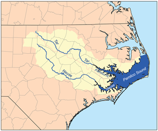
The Neuse River is a river rising in the Piedmont of North Carolina and emptying into Pamlico Sound below New Bern. Its total length is approximately 275 miles (443 km), making it the longest river entirely contained in North Carolina. The Trent River joins the Neuse at New Bern. Its drainage basin, measuring 5,630 square miles (14,600 km2) in area, also lies entirely inside North Carolina. It is formed by the confluence of the Flat and Eno rivers prior to entering the Falls Lake reservoir in northern Wake County. Its fall line shoals, known as the Falls of the Neuse, lie submerged under the waters of Falls Lake. This River also creates the beauty of the Neuse River Trail, a 34.5 miles (55.5 km) long greenway that stretches from Falls Lake Dam, Raleigh, North Carolina to Legend Park, Clayton, North Carolina.

The Humboldt River is an extensive river drainage system located in north-central Nevada. It extends in a general east-to-west direction from its headwaters in the Jarbidge, Independence, and Ruby Mountains in Elko County, to its terminus in the Humboldt Sink, approximately 225 miles (362 km) away in northwest Churchill County. Most estimates put the Humboldt River at 300 to 330 miles long; however, due to the extensive meandering nature of the river, its length may be more closely estimated at 380 miles (610 km). It is located within the Great Basin Watershed and is the third-longest river in the watershed behind the Bear River at 355 miles (571 km) and the Sevier River at 325 miles (523 km). The Humboldt River Basin is the largest sub-basin of the Great Basin, encompassing an area of 16,840 square miles (43,600 km2). It is the only major river system wholly contained within the state of Nevada.

The Owyhee River is a tributary of the Snake River located in northern Nevada, southwestern Idaho and southeastern Oregon in the United States. It is 280 miles (450 km) long. The river's drainage basin is 11,049 square miles (28,620 km2) in area, one of the largest subbasins of the Columbia Basin. The mean annual discharge is 995 cubic feet per second (28.2 m3/s), with a maximum of 50,000 cu ft/s (1,400 m3/s) recorded in 1993 and a minimum of 42 cu ft/s (1.2 m3/s) in 1954.

The Feather River is the principal tributary of the Sacramento River, in the Sacramento Valley of Northern California. The river's main stem is about 73 miles (117 km) long. Its length to its most distant headwater tributary is just over 210 miles (340 km). The main stem Feather River begins in Lake Oroville, where its four long tributary forks join—the South Fork, Middle Fork, North Fork, and West Branch Feather Rivers. These and other tributaries drain part of the northern Sierra Nevada, and the extreme southern Cascades, as well as a small portion of the Sacramento Valley. The total drainage basin is about 6,200 square miles (16,000 km2), with approximately 3,604 square miles (9,330 km2) above Lake Oroville.

The Independence Mountains are a mountain range in northern Elko County, Nevada, United States. They are called Settoya in Shoshoni. The range reaches a maximum elevation of 10,439 ft (3,182 m) on the summit of McAfee Peak. The range extends northward approximately 70 mi (110 km) from a point near Carlin to the banks of the Owyhee River. To the east is the North Fork of the Humboldt River, and to the west is the Owyhee Desert. Passing to the south is the main branch of the Humboldt River, and near the northern end of the range is the Wild Horse State Recreation Area. The Owyhee River is a tributary to the Snake-Columbia system, while the Humboldt is within the Great Basin.

Tuscarora is an unincorporated community in Elko County, Nevada, United States. The community lies on the east side of the Tuscarora Mountains approximately 40 miles north of Carlin. Tuscarora is part of the Elko Micropolitan Statistical Area. Far from being a ghost town, as several websites proclaim, Tuscarora is home to two schools, a library, a post office and a bar and grill, as well as homes for its remaining residents.

Glenbrook is a census-designated place (CDP) on the east shore of Lake Tahoe in Douglas County, Nevada, United States. The population was 215 at the 2010 census. Beach and Bay are for residents and renters living in Glenbrook's gated community. There is no public access to the beach or bay.
You Bet is a small unincorporated community in Nevada County, California. You Bet is located in the Sierra Nevada foothills, 7 miles (11.3 km) east of Grass Valley and 5.5 miles (8.9 km) northeast of Chicago Park.
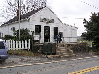
Tuscarora is a small unincorporated community in southern Frederick County, in the U.S. state of Maryland. Maryland Route 28 runs through the village. The community was named for Tuscarora Creek that runs in the area. There is an old, small post office that is in the area along Route 28. The area was formerly named "Licksville" after another creek in the area. It is bordered by Point of Rocks to the west and Adamstown to the north. The Nolands Ferry I Archeological Site was listed on the National Register of Historic Places in 1985.
Birchville is a historic mining and agricultural community in Nevada County, California. Birchville is located about 10 miles northwest of Nevada City and about 2 miles northeast of French Corral. It is situated at an elevation of 1,765 ft (538 m) above sea level.
Little York is the name of one of the first gold mining towns established in Nevada County, California as well as the name of the township in which it was situated. The town was located on the Lowell Ridge between Steephollow Creek and the Bear River, about 13 miles east of Nevada City, California and about 1 mile southwest of Dutch Flat, California at an elevation of about 2800 feet.
Hunt's Hill is a former mining camp in Nevada County, California, United States. Hunt's Hill was located in the Sierra Nevada foothills about 6 miles in a straight line southeast of Nevada City and about 2 miles northwest of You Bet, on the north side of Greenhorn Creek, not far from the present intersection of Red Dog and Buckeye Roads. Hunt's Hill was founded in 1852 by a miner named Hunt. It was located on one of the deepest parts of the rich Blue Lead channel of gold-bearing gravel. In 1855, one of the mining claims established by some French miners, was “jumped". During the fight, one of the French miners lost an eye. Thereafter, that mine, and sometimes the town, were called Gouge Eye. By 1857, the town boasted two saloons, a hotel, a blacksmith and stable, a butcher shop, a boot and shoe store, and several grocery stores. In 1858, a stage line from Nevada City arrived. In 1866, seven cement mills for extracting gold from the “blue cement” were operating in the area. By 1880, the town was reduced to a combined store and saloon and a few houses. In 1895, one directory summed up the state of the community thus: "At the present time there is not much doing there." Since that same directory identified the town's justice of the peace and constable, what little happened must have been interesting. Today, it is just a historic site.

Springville is a city in Utah County, Utah, United States, that is part of the Provo–Orem metropolitan area. The population was 35,268 in 2020, according to the United States Census. Springville is a bedroom community for commuters who work in the Provo-Orem and Salt Lake City metropolitan areas. Other neighboring cities include Spanish Fork and Mapleton. Springville has the nickname of "Art City" or "Hobble Creek".
Remington Hill is a historic mining camp in Nevada County, California which prospered in the second half of the 19th century. It was named for Caleb Remington, a prominent local miner who lived mostly in neighboring Little York, where he died in 1865. It lay at an elevation of 4052 feet. It was situated around present Chalk Bluff Road about one mile south of Highway 20 and about 5.5 miles southeast of the town of Washington and 6 miles northeast of Dutch Flat, as the crow flies.
Huntington is a ghost town in Elko County, Nevada, United States.

Maggie Creek is a southward flowing 85.4-mile-long (137.4 km) stream that begins in the Independence Mountains and is a tributary to the Humboldt River in Carlin in Elko County in northeastern Nevada.


