Elko County is a county in the northeastern corner of Nevada, United States. As of the 2020 census, the population was 53,702. Its county seat is Elko. The county was established on March 5, 1869, from Lander County.

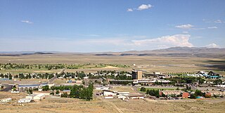
Elko is a city in the U.S. state of Nevada and the county seat of Elko County. As of the official 2020 U.S. Census, the city has a population of 20,564. Elko serves as the center of the Ruby Valley, a region with a population of over 55,000. Elko is 21 miles (34 km) from Lamoille Canyon and the Ruby Mountains, providing year-round access to recreation, including hiking, skiing, hunting, and more than 20 alpine lakes. The city straddles the Humboldt River. Spring Creek, Nevada, serves as a bedroom community 6 miles (10 km) from the city with a population of 13,805.
Jackpot is an unincorporated community and census-designated place (CDP) in Elko County, Nevada, United States. The population was 855 as of the 2020 census. Located less than one mile (1.6 km) from the Idaho border on US 93, Jackpot has been a popular casino gaming destination for residents of Idaho and other neighboring states since its founding.

Jarbidge is an unincorporated community in Elko County, Nevada, United States. Located at the bottom of the Jarbidge River's canyon near the north end of the Jarbidge Mountains, it lies within the Jarbidge Ranger District of the Humboldt-Toiyabe National Forest and is near the northwest edge of the Jarbidge Wilderness, approximately 10 miles (16 km) south of the Idaho–Nevada border.

KTVN is a television station in Reno, Nevada, United States, affiliated with CBS. Owned by Sarkes Tarzian, Inc., the station maintains studios on Energy Way in Reno, and its transmitter is located on Slide Mountain in unincorporated Washoe County.

State Route 223 is a state highway in Elko County, Nevada, United States. Co-signed with Interstate 80 Business, it serves the town of Wells.

State Route 228 (SR 228), also known as Jiggs Highway, is a 20.803-mile (33.479 km) state highway in Elko County, Nevada, United States, that connects Jiggs with Nevada State Route 227 in Spring Creek.

State Route 230 (SR 230) is a state highway central Elko County, Nevada, United States. It is a southern loop route off of Interstate 80 (I‑80) between Elko and Wells, serving the communities of Deeth and Welcome and various ranches within Starr Valley. The road follows a U-shaped path and passes close to the East Humboldt Range. The road was constructed by 1962, but was not designated as a state highway until 1992.

State Route 231 is an unsigned state highway in Elko County, Nevada, United States. Known as Angel Lake Road, the highway connects Angel Lake to the town of Wells. SR 231 is a Nevada Scenic Byway.
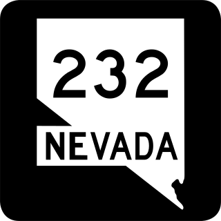
State Route 232 is a state highway in Elko County, Nevada. It covers the majority of Clover Valley Road south of Wells.

KNPB, branded PBS Reno, is a PBS member television station in Reno, Nevada, United States, owned by Channel 5 Public Broadcasting, Inc. The station's studios are located on North Virginia Street in Reno, and its transmitter is located on Red Hill between US 395 and SR 445 in Sun Valley.

San Jacinto is a ghost town in along Salmon Falls Creek in northern Elko County, Nevada, United States. It is part of the Elko Micropolitan Statistical Area.

State Route 767 is a short state highway in the Ruby Valley region of Elko County, Nevada. It follows a portion of Ruby Valley Road.

State Route 766 is a state highway in north central Nevada. It runs from the town of Carlin north to serve Newmont Mine.
State Route 535 (SR 535) is the Nevada Department of Transportation (NDOT) designation for two discontinuous sections of Idaho Street just west of and within the small city of Elko in the northeastern part of the U.S. state of Nevada. Both segments are also signed as Interstate 80 Business, which is also signed along the city-maintained segment of Idaho Street between the two NDOT segments as well as the city-maintained segment of Idaho Street east of the final eastern terminus all the way to East Jennings Way, from which it connects to the Elko East exit on Interstate 80. Most of Interstate 80 Business in Elko, including both segments of SR 535, were formerly designated U.S. Route 40.

The Carlin Tunnel is a collective name for a set of four tunnel bores in the Humboldt River's Carlin Canyon, east of Carlin in Elko County, Nevada, United States. The two railroad bores were constructed for different purposes at different times, while the two highway bores were constructed concurrently, all with the goal of bypassing a sharp bend in the river. Currently, two of the bores carry Interstate 80, while the other two bores carry Union Pacific Railroad's Overland Route and Central Corridor. Bridges over the Humboldt River are adjacent to both portals of three tubes, including the two freeway bores and one of the railroad bores.

KENV-DT is a television station licensed to Elko, Nevada, United States, broadcasting the digital multicast network TBD. Owned by Cunningham Broadcasting, it is operated under a joint sales agreement by TBD owner Sinclair Broadcast Group. KENV's studios are located on the campus of Great Basin College on Chilton Circle in Elko, and its transmitter is located on Grindstone Mountain.
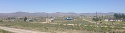
Osino is a census-designated place (CDP) in along the Humboldt River in central Elko County, Nevada, United States. As of the 2018 United States Census American Community Survey it had a population of 661.
East Peak is a summit in Elko County in the U.S. state of Nevada. The elevation is 6,194 feet (1,888 m). The peak rises above the Humboldt River valley and the community of Ryndon about two miles to the north and the main peak of Elko Mountain is about two miles to the west-southwest.