
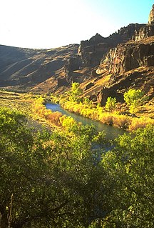
The Humboldt River is an extensive river drainage system located in north-central Nevada. It extends in a general east-to-west direction from its headwaters in the Jarbidge, Independence, and Ruby Mountains in Elko County, to its terminus in the Humboldt Sink, approximately 225 direct miles away in northwest Churchill County. Most estimates put the Humboldt River at 300 miles (480 km) to miles 330 miles (530 km) long however, due to the extensive meandering nature of the river, its length may be more closely estimated at 380 miles (612 km). It is located within the Great Basin Watershed and is the third longest river in the watershed behind the Bear River at 355 miles (570 km) and the Sevier River at 325 miles (523 km). The Humboldt River Basin is the largest sub-basin of the Great Basin encompassing an area of 16,840 square miles (43,615 km2). It is the only major river system wholly contained within the state of Nevada.
The Owyhee River is a tributary of the Snake River located in northern Nevada, southwestern Idaho and southeastern Oregon in the United States. It is 280 miles (450 km) long. The river's drainage basin is 11,049 square miles (28,620 km2) in area, one of the largest subbasins of the Columbia Basin. The mean annual discharge is 995 cubic feet per second (28.2 m3/s), with a maximum of 50,000 cu ft/s (1,400 m3/s) recorded in 1993 and a minimum of 42 cu ft/s (1.2 m3/s) in 1954.

The Feather River is the principal tributary of the Sacramento River, in the Sacramento Valley of Northern California. The river's main stem is about 73 miles (117 km) long. Its length to its most distant headwater tributary is just over 210 miles (340 km). The main stem Feather River begins in Lake Oroville, where its four long tributary forks join—the South Fork, Middle Fork, North Fork, and West Branch Feather Rivers. These and other tributaries drain part of the northern Sierra Nevada, and the extreme southern Cascades, as well as a small portion of the Sacramento Valley. The total drainage basin is about 6,200 square miles (16,000 km2), with approximately 3,604 square miles (9,330 km2) above Lake Oroville.
The Ruby Mountains are a mountain range, primarily located within Elko County with a small extension into White Pine County, in Nevada, United States. Most of the range is included within the Humboldt-Toiyabe National Forest. The range reaches a maximum elevation of 11,387 feet (3,471 m) on the summit of Ruby Dome. To the north is Secret Pass and the East Humboldt Range, and from there the Rubies run south-southwest for about 80 miles (130 km). To the east lies Ruby Valley, and to the west lie Huntington and Lamoille Valleys. The Ruby Mountains are the only range of an introduced bird, the Himalayan snowcock, in North America.

The Jarbidge River is a 51.8-mile-long (83.4 km), high elevation river in Elko County, Nevada and Owyhee County, Idaho in the United States. The Jarbidge originates as two main forks in the Jarbidge Mountains of northeastern Nevada and then flows through basalt and rhyolite canyons on the high plateau of the Owyhee Desert before joining the Bruneau River.

Dollar Lakes are a group of three glacial tarns in the Ruby Mountains of Elko County, Nevada, United States. They are within the Ruby Mountains Ranger District of the Humboldt-Toiyabe National Forest. The lakes are located near the head of Lamoille Canyon at approximately 40°35′30″N115°23′6″W, and at an elevation of 9626 feet. They have a combined area of approximately 3 acres, and an estimated depth of up to 15 feet. The Ruby Crest National Recreation Trail runs along the western shore of the lakes.

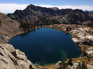
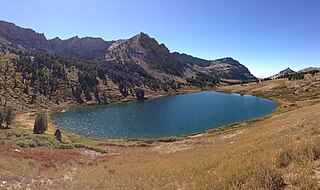
Echo Lake is a glacial tarn in the Ruby Mountains, in Elko County in the northeastern part of the state of Nevada. It is located at the head of remote Echo Canyon at approximately 40°36.7′N115°26.8′W, and at an elevation of 9830 feet. It has an area of approximately 29 acres, and a depth of up to 155 feet, making it both the largest and deepest lake in the Ruby Mountains. It is the major source of Echo Creek, which after exiting the mountains merges with other streams to form the South Fork of the Humboldt River.

North Furlong Lake is a glacial tarn in the Ruby Mountains, in Elko County in the northeastern part of the state of Nevada. It is located at the head of North Furlong Canyon at approximately 40°33.4′N115°24.8′W, and at an elevation of 9590 feet. It has an area of approximately 16 acres, and a depth of up to 20 feet. This is a common camp for users of the Ruby Crest National Recreation Trail, which passes nearby.
Liberty Lake is a glacial tarn in the Ruby Mountains of Elko County, Nevada, United States. It is within the Ruby Mountains Wilderness, which is administered by the Ruby Mountains Ranger District of the Humboldt-Toiyabe National Forest. The lake is located near the head of Kleckner Canyon at approximately 40°34.8′N115°23.7′W, and at an elevation of 10,039 feet. It has an area of approximately 21 acres, and a depth of up to 108 feet. It is one of the sources of Kleckner Creek, which after exiting the mountains merges with other streams to form the South Fork of the Humboldt River. The Ruby Crest National Recreation Trail runs along the western shore of the lake.

Seitz Lake is a glacial tarn in the Ruby Mountains, in Elko County in the northeastern part of the state of Nevada. It is located near the head of Seitz Canyon at approximately 40°38.2′N115°27.4′W, and at an elevation of 8915 feet. It has an area of approximately 17 acres, and a depth of up to 20 feet.
Verdi Lake is a glacial tarn in the Ruby Mountains of Elko County, Nevada, United States. It is within the Ruby Mountains Wilderness, which is administered by the Ruby Mountains Ranger District of the Humboldt-Toiyabe National Forest. The lake is located at the head of Talbot Canyon at approximately 40°38.9′N115°21.2′W, and at an elevation of 10,184 feet. Directly to the south rises Verdi Peak. It has an area of approximately 6 acres, and a depth of up to 86 feet.

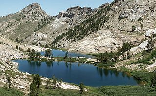
Lamoille Lake is a glacial tarn in the Ruby Mountains of Elko County, Nevada, United States. It is within the Ruby Mountains Ranger District of the Humboldt-Toiyabe National Forest. The lake is located at the head of Lamoille Canyon, at approximately 40°34.6′N115°23.7′W, and at an elevation of 9,747 feet. It has an area of approximately 13.6 acres. It is a popular destination for day hikers and fishing, as the Ruby Crest National Recreation Trail passes its eastern shore before beginning a steep climb to Liberty Pass.
The Hidden Lakes are a pair of glacial tarns in the Ruby Mountains, in Elko County in the northeastern part of the state of Nevada. They are located on a shelf on the Ruby Crest above Soldier Basin, at approximately 40°44.6′N115°17.0′W, and at an elevation of 9500 feet. They have a combined area of approximately 9 acres, and a depth of up to 32 feet.
Favre Lake is a glacial tarn in the Ruby Mountains of Elko County, Nevada, United States. It is within the Ruby Mountains Wilderness, which is administered by the Ruby Mountains Ranger District of the Humboldt-Toiyabe National Forest. The lake is located at the head of Kleckner Canyon, at approximately 40°34.4′N115°23.8′W, and at an elevation of 9511 feet. It has an area of approximately 19 acres, and a depth of up to 45 feet. It is one of the sources of Kleckner Creek, which after exiting the mountains merges with other streams to form the South Fork of the Humboldt River.

Castle Lake is a glacial tarn in the Ruby Mountains of Elko County, Nevada, United States. It is within the Ruby Mountains Wilderness, which is administered by the Ruby Mountains Ranger District of the Humboldt-Toiyabe National Forest. The lake is located on a shelf near the head of Kleckner Canyon, at approximately 40°34.1′N115°23.9′W, and at an elevation of 9,793 feet immediately below Lake Peak. It has an area of approximately 14 acres (57,000 m2), and a depth of up to 15 feet. It is one of the sources of Kleckner Creek, which after exiting the mountains merges with other streams to form the South Fork of the Humboldt River.
Cold Lakes are a pair of glacial tarns in the Ruby Mountains, in Elko County in the northeastern part of the state of Nevada. They are located at the head of Cold Creek Canyon, at approximately 40°42.9′N115°18.1′W, and at an elevation of 9880 feet. They have a combined area of approximately 7.4 acres, and a depth of up to 28 feet.
The Ruby Crest National Recreation Trail is a National Recreation Trail in the upper elevations of the central Ruby Mountains, in Elko County, Nevada, United States. Approximately 38 miles (61 km) in length, the trail is used by hikers and pack trains to experience some of the most spectacular scenery in the western United States.
The Soldier Lakes are a cluster of more than a dozen glacial tarns in the Ruby Mountains, in Elko County in the northeastern part of the state of Nevada. They are located on the shelf of Soldier Basin on the eastern side of the mountains, at approximately 40°44.1′N115°16.4′W, and at an elevation of 9100 feet. They have a combined area of approximately 6 acres, and a depth of up to 14 feet.
Right Fork Canyon is a major branch of Lamoille Canyon, located in the Ruby Mountains of Elko County, in the northeastern section of the state of Nevada in the western United States. Approximately 5 miles (8 km) in length, it was extensively sculpted by glaciers in previous ice ages.

Seitz Canyon is one of the major canyons and valleys within the Ruby Mountains of Elko County, in the northeastern section of the state of Nevada in the western United States. Approximately 5.5 miles (8.9 km) in length, it was extensively sculptured by glaciers in previous ice ages. Remote, scenic, and ecologically diverse, it is protected in both the Ruby Mountains Wilderness Area and the Seitz-Echo Research Natural Area.


