Hastings Cutoff

Last updated
Hastings Cutoff
HastingsCutoff.gif
Route of the California Trail and Hastings Cutoff in the western United States.
LocationHumboldt River Basin, Elko County
Official nameWest End of Hastings Cutoff
Reference no.3 [1]

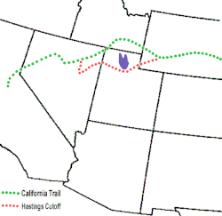
The Hastings Cutoff was an alternative route for westward emigrants to travel to California, as proposed by Lansford Hastings in The Emigrant's Guide to Oregon and California. The ill-fated Donner Party infamously took the route in 1846.

Contents

Description

A sentence in Hastings' guidebook briefly describes the cutoff:

The most direct route, for the California emigrants, would be to leave the Oregon route, about two hundred miles east from Fort Hall; thence bearing West Southwest, to the Salt Lake; and thence continuing down to the bay of St. Francisco, by the route just described.

The cutoff left the Oregon Trail at Fort Bridger in Wyoming, passed through the Wasatch Range, across the Great Salt Lake Desert, an 80-mile nearly water-less drive, looped around the Ruby Mountains, and rejoined the California Trail about seven miles west of modern Elko (also Emigrant Pass).

The west end of the cutoff is marked as Nevada Historical Marker 3. [1]

Trail use

Hastings led a small party overland late in 1845 and spent the winter in California. Significantly, his stay at Sutter's Fort coincided with a visit by John C. Frémont, who had just explored the Great Salt Lake Desert and whose letter describing a new route to California would be widely published in Eastern newspapers. In April, Hastings set out with a few companions to meet the emigration of 1846. He stayed in the vicinity of the Sweetwater River while an eastbound traveler carried his open letter inviting emigrants on the California Trail to meet him at Fort Bridger. Between 60 and 75 wagons did so and traveled with Hastings on his cutoff. They endured a difficult descent down Weber Canyon, a waterless drive of 80 miles across the Great Salt Lake Desert, and a lengthy detour around the Ruby Mountains. Despite the usual trials of overland travel, they arrived safely in California.

Hastings Cutoff marker near Pilot Peak 2014-06-29 05 19 20 Sign for the California Trail along Leppy Pass Road near Pilot Peak, Nevada.JPG
Hastings Cutoff marker near Pilot Peak

The Donner Party, following in the wake of this initial party in 1846, had an unsuccessful experience with the Hastings Cutoff. They had arrived about a week early to travel with Hastings' party, and on his suggestion pioneered an alternate route to avoid Weber Canyon. The roadbuilding required through the Wasatch Mountains and the grueling Great Salt Lake Desert delayed them. When they had arrived at the California Trail, they were delayed about a month. The party arrived at Donner Pass just as an early winter storm rendered it impassable. After becoming snowbound in the Sierra Nevada, many died of starvation, and some of the emigrants resorted to eating their animals and the deceased members of the group.

In July 1847, Mormon leader Brigham Young led a vanguard company of emigrants from Winter Quarters, in what is now Omaha, to the future site of Salt Lake City. The company chose to use the Hastings Cutoff passing through modern-day Emigration Canyon. Young's group made remarkable improvements to some parts of the cutoff on their journey so subsequent Mormon companies could more easily make it through to the Salt Lake valley. William Clayton, the company's scribe, stated in his journals that the company tried to follow the route left by the Donner Party the previous year, yet only occasionally could identify the tracks.

The California gold rush created an enormous increase in westward traffic and several parties of 1849 and 1850 used the Hastings Cutoff. The year 1850 saw the development of a new route called the Salt Lake Cutoff that avoided the Great Salt Lake Desert west of the lake. Subsequently, the Hastings Cutoff was abandoned, except for portions east of Salt Lake City, where it remained as the end of the Mormon Trail.

See also

Related Research Articles

<span class="mw-page-title-main">Oregon Trail</span> Historic route connecting the Missouri River to valleys in Oregon

The Oregon Trail was a 2,170-mile (3,490 km) east–west, large-wheeled wagon route and emigrant trail in the United States that connected the Missouri River to valleys in Oregon Territory. The eastern part of the Oregon Trail spanned part of what is now the state of Kansas and nearly all of what are now the states of Nebraska and Wyoming. The western half of the trail spanned most of the current states of Idaho and Oregon.

<span class="mw-page-title-main">Fort Bridger</span> United States historic place

Fort Bridger was originally a 19th-century fur trading outpost established in 1842, on Blacks Fork of the Green River, in what is now Uinta County, Wyoming, United States. It became a vital resupply point for wagon trains on the Oregon Trail, California Trail, and Mormon Trail. The Army established a military post here in 1858 during the Utah War, until it was finally closed in 1890. A small town, Fort Bridger, Wyoming, remains near the fort and takes its name from it.

<span class="mw-page-title-main">Donner Party</span> 19th-century group of American emigrants who became trapped in the Sierra Nevada mountains

The Donner Party, sometimes called the Donner–Reed Party, were a group of American pioneers who migrated to California in a wagon train from the Midwest. Delayed by a multitude of mishaps, they spent the winter of 1846–1847 snowbound in the Sierra Nevada mountain range. Some of the migrants resorted to cannibalism to survive, primarily eating the bodies of those who had succumbed to starvation, sickness or extreme cold, but in one case two Native American guides were deliberately killed for this purpose.

<span class="mw-page-title-main">Mormon Trail</span> Migrant route from Illinois to Salt Lake City, Utah

The Mormon Trail is the 1,300-mile (2,100 km) long route from Illinois to Utah on which Mormon pioneers traveled from 1846–47. Today, the Mormon Trail is a part of the United States National Trails System, known as the Mormon Pioneer National Historic Trail.

<span class="mw-page-title-main">California Trail</span> Historic migration route in the western United States

The California Trail was an emigrant trail of about 1,600 mi (2,600 km) across the western half of the North American continent from Missouri River towns to what is now the state of California. After it was established, the first half of the California Trail followed the same corridor of networked river valley trails as the Oregon Trail and the Mormon Trail, namely the valleys of the Platte, North Platte, and Sweetwater rivers to Wyoming. The trail has several splits and cutoffs for alternative routes around major landforms and to different destinations, with a combined length of over 5,000 mi (8,000 km).

<span class="mw-page-title-main">City of Rocks National Reserve</span> Protected natural area in Idaho, United States

The City of Rocks National Reserve, also known as the Silent City of Rocks, is a United States National Reserve and state park in south-central Idaho, approximately 2 miles (3.2 km) north of the border with Utah. It is widely known for its enormous granite rock formations and excellent rock climbing.

<span class="mw-page-title-main">Great Salt Lake Desert</span> Large dry lake in northern Utah, United States

The Great Salt Lake Desert is a large dry lake in northern Utah, United States, between the Great Salt Lake and the Nevada border. It is a subregion of the larger Great Basin Desert, and noted for white evaporite Lake Bonneville salt deposits including the Bonneville Salt Flats.

<span class="mw-page-title-main">Lansford Hastings</span> American explorer (1819–1870)

Lansford Warren Hastings (1819–1870) was an American explorer and Confederate soldier. He is best remembered as the developer of Hastings Cutoff, a claimed shortcut to California across what is now the state of Utah, a factor in the Donner Party disaster of 1846. He was a Major in the Confederate States Army during the American Civil War.

<span class="mw-page-title-main">Applegate Trail</span> United States historic place

The Applegate Trail was an emigrant trail through the present-day U.S. states of Idaho, Nevada, California, and Oregon used in the mid-19th century by emigrants on the American frontier. It was originally intended as a less dangerous alternative to the Oregon Trail by which to reach the Oregon Territory. Much of the route was coterminous with the California Trail.

<span class="mw-page-title-main">Peter Lassen</span> American rancher and prospector

Peter Lassen, later known in Spanish as Don Pedro Lassen, was a Danish-born Californian ranchero and gold prospector. Born in Denmark, Lassen immigrated at age 30 to Massachusetts, before eventually moving to California. In California, Lassen became a Mexican citizen and received the vast Rancho Bosquejo from Governor Manuel Micheltorena. He is best known as the eponym of Lassen County, California, Lassen Peak, and Lassen Volcanic National Park.

<span class="mw-page-title-main">Death Valley '49ers</span> Aspect of the California Gold Rush

The Death Valley '49ers were a group of pioneers from the Eastern United States that endured a long and difficult journey during the late 1840s California Gold Rush to prospect in the Sutter's Fort area of the Central Valley and Sierra Nevada in California. Their route from Utah went through the Great Basin Desert in Nevada, and Death Valley and the Mojave Desert in Southern California, in attempting to reach the Gold Country.

<span class="mw-page-title-main">Interstate 80 in Nevada</span> Section of Interstate Highway in Nevada, United States

Interstate 80 (I-80) traverses the northern portion of the US state of Nevada. The freeway serves the Reno metropolitan area and passes through the towns of Fernley, Lovelock, Winnemucca, Battle Mountain, Carlin, Elko, Wells, and West Wendover on its way through the state.

In 1841, the Bartleson–Bidwell Party, led by Captain John Bartleson and John Bidwell, became the first American emigrants to attempt a wagon crossing from Missouri to California.

<span class="mw-page-title-main">Emigrant Trail in Wyoming</span> 19th century pioneer route in western United States

The Emigrant Trail in Wyoming, which is the path followed by Western pioneers using the Oregon, California, and Mormon Trails, spans 400 miles (640 km) through the U.S. state of Wyoming. The trail entered from Nebraska on the eastern border of the state near the present day town of Torrington and exited on the western border near the towns of Cokeville and Afton. An estimated 350,000 to 400,000 settlers traveled on the trail through Wyoming between 1841 and 1868. All three trails follow the same path through most of the state. The Mormon Trail splits at Fort Bridger and enters Utah, while the Oregon and California Trails continue to Idaho.

The Salt Lake Cutoff is one of the many shortcuts that branched from the California, Mormon and Oregon Trails in the United States. It led northwest out of Salt Lake City, Utah and north of the Great Salt Lake for about 180 miles (290 km) before rejoining the California trail near the City of Rocks, Idaho. From there Oregon Trail travelers could easily travel down the Raft River valley portion of the California Trail to return to the Oregon Trail. It provided a way to stop in Salt Lake City for repairs, fresh supplies, fresh livestock, etc. In later years it was used by tens of thousands of pioneers and miners going east and west on their way to or from the future states of California, Oregon, Utah, Idaho, Montana, Nevada or Washington.

<span class="mw-page-title-main">Lake Point, Utah</span> City in Utah, United States

Lake Point is a city on the eastern edge of northern Tooele County, Utah, United States. It is located 17 miles southwest of Salt Lake City International Airport and 11 miles north of Tooele, Utah. At its location on the south shore of the Great Salt Lake, the city is served by Interstate 80 and Utah State Route 36.

The Overland Trail was a stagecoach and wagon trail in the American West during the 19th century. While portions of the route had been used by explorers and trappers since the 1820s, the Overland Trail was most heavily used in the 1860s as a route alternative to the Oregon, California, and Mormon trails through central Wyoming. The Overland Trail was famously used by the Overland Stage Company owned by Ben Holladay to run mail and passengers to Salt Lake City, Utah, via stagecoaches in the early 1860s. Starting from Atchison, Kansas, the trail descended into Colorado before looping back up to southern Wyoming and rejoining the Oregon Trail at Fort Bridger. The stage line operated until 1869 when the completion of the First transcontinental railroad eliminated the need for mail service via stagecoach.

In the history of the American frontier, pioneers built overland trails throughout the 19th century, especially between 1829 and 1870, as an alternative to sea and railroad transport. These immigrants began to settle much of North America west of the Great Plains as part of the mass overland migrations of the mid-19th century. Settlers emigrating from the eastern United States did so with various motives, among them religious persecution and economic incentives, to move from their homes to destinations further west via routes such as the Oregon, California, and Mormon Trails. After the end of the Mexican–American War in 1849, vast new American conquests again encouraged mass immigration. Legislation like the Donation Land Claim Act and significant events like the California Gold Rush further encouraged settlers to travel overland to the west.

<span class="mw-page-title-main">Route of the Oregon Trail</span>

The historic 2,170-mile (3,490 km) Oregon Trail connected various towns along the Missouri River to Oregon's Willamette Valley. It was used during the 19th century by Great Plains pioneers who were seeking fertile land in the West and North.

Mormon Road, also known to the 49ers as the Southern Route, of the California Trail in the Western United States, was a seasonal wagon road pioneered by a Mormon party from Salt Lake City, Utah led by Jefferson Hunt, that followed the route of Spanish explorers and the Old Spanish Trail across southwestern Utah, northwestern Arizona, southern Nevada and the Mojave Desert of California to Los Angeles in 1847. From 1855, it became a military and commercial wagon route between California and Utah, called the Los Angeles – Salt Lake Road. In later decades this route was variously called the "Old Mormon Road", the "Old Southern Road", or the "Immigrant Road" in California. In Utah, Arizona and Nevada it was known as the "California Road".

References

Citations

  1. 1 2 "Nevada Historical Markers". Nevada State Historic Preservation Office. Archived from the original on 4 February 2013. Retrieved 23 February 2013.

General references