The flag of Nevada
The seal of Nevada
The following outline is provided as an overview of and topical guide to the U.S. state of Nevada:
Contents
- General reference
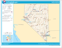
- Geography of Nevada
- Places in Nevada
- Environment of Nevada
- Regions of Nevada
- Demography of Nevada
- Government and politics of Nevada
- Branches of the government of Nevada
- Law and order in Nevada
- Military in Nevada
- History of Nevada
- History of Nevada, by period
- History of Nevada, by region
- History of Nevada, by subject
- Culture of Nevada
- The Arts in Nevada
- Sports in Nevada
- Economy and infrastructure of Nevada
- Education in Nevada
- See also
- References
- External links
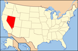
Nevada – U.S. state in the intermountain west region of the United States. Nevada is mostly desert or semiarid. Over two-thirds of Nevada's people live in the Las Vegas metropolitan area, [1] and about 86% of the state's land is owned by the US government, under various departments and agencies. [2]