The 39th meridian west from Washington is an archaic meridian based on the Washington meridian. The meridian is currently used as a boundary for two states.
The first usage of the meridian as a boundary occurred in 1861, when Nevada Territory was created from the western part of Utah Territory. Initially, the eastern boundary of Nevada Territory was set at this meridian. [1] However, in 1862, that boundary was moved a degree east to follow the 38th meridian, and a few years later was moved still further east to the 37th meridian.
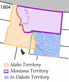
The 39th meridian was used again for a boundary in 1864. In that year, the Montana Territory was created from Idaho Territory with the meridian serving as its extreme northwestern boundary. [2] Montana became a state in 1889, with Idaho following the next year. [3] [4]