Idaho Territory

Last updated

Territory of Idaho
Organized incorporated territory of the United States
1863–1890
Idaho territory coat of arms (illustrated, 1876).jpg
Coat of arms of the Idaho Territory (1863–1866)
Capital Lewiston (1863–1866)
Boise (1866–1890)
Government
  Type Organized incorporated territory
Governor  
 First
William H. Wallace
 Last
George L. Shoup
History 
 Split from Dakota, Nebraska, and Washington territories
March 3, 1863
  Montana Territory split off & land ceded to Dakota Territory
May 28, 1864
  Wyoming Territory formed
July 25, 1868
  Statehood
July 3, 1890
Preceded by
Succeeded by
US flag 34 stars.svg Washington Territory
US flag 34 stars.svg Dakota Territory
Montana Territory US flag 35 stars.svg
Dakota Territory US flag 35 stars.svg
Wyoming Territory US flag 37 stars.svg
Idaho Flag of Idaho (1907-1927).png
Seal of the Idaho Territory, 1863-1866 Seal of Idaho (1863-1866).jpg
Seal of the Idaho Territory, 1863–1866

The Territory of Idaho was an organized incorporated territory of the United States that existed from March 3, 1863, [1] until July 3, 1890, when the final extent of the territory was admitted to the Union as Idaho.

Contents

History

Historical population
YearPop.±%
1870 14,999    
1880 32,610+117.4%
1890 88,548+171.5%
Source: 1870–1890; [2]

1860s

The territory was officially organized on March 3, 1863, by Act of Congress, [1] and signed into law by President Abraham Lincoln. It is a successor region that was created by areas from existing territories undergoing parallel political transitions beginning with disputes over which country owned the region (See Oregon Country). By 1863, the area west of the Continental Divide that was formerly part of the huge Oregon Territory had been sundered from the coastal Washington Territory north of the young State of Oregon to the far west and the remnant of the Oregon Territory was officially "unorganized". Most of the area east of the Continental Divide had been part of the loosely defined Dakota Territory ending along the 49th parallel—now the border with Canada, then a colonial possession of Great Britain.

The original newly organized territory covered all of the present-day states of Idaho and Montana, and almost all of the present-day state of Wyoming, omitting only a corner in the state's extreme southwest portion. It was wholly spanned east-to-west by the bustling Oregon Trail and partly by the other emigrant trails, the California Trail and Mormon Trail which since hitting stride in 1847, had been conveying settler wagon trains to the west, and incidentally, across the continental divide into the Snake River Basin, a key gateway into the Idaho and Oregon Country interiors.

The first territorial capital was at Lewiston [3] from the inception in 1863 to 1866. Boise was made the territorial capital from 1866 by a one-vote margin of the Territorial Supreme Court. Congress failed to provide official criminal or civic codes for the Idaho territory upon its inception. It was not until January 4th, 1864 that the territory's original laws were adopted. [4]

The upheaval caused by the Civil War and Reconstruction was a distant concern to those in the comparatively stable Idaho Territory, a situation which in turn encouraged settlement.

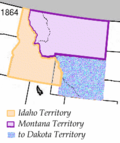
In 1864, the Montana Territory was organized from the northeastern section of the territory east of the Bitterroot Range. Most of the southeastern area of the territory was made part of the Dakota Territory.

In the late 1860s, Idaho Territory became a destination for displaced Southern Democrats who fought for the Confederate States of America during the Civil War. These people were well represented in the early territorial legislatures, which often clashed with the appointed Republican territorial governors. The political infighting became particularly vicious in 1867 when Governor David W. Ballard asked for protection from federal troops stationed at Fort Boise against the territorial legislature. By 1870, however, the political infighting had decreased considerably.

In 1868, the areas east of the 111th meridian west were made part of the newly created Wyoming Territory. Idaho Territory assumed the boundaries of the modern state at that time. The discovery of gold, silver and other valuable natural resources throughout Idaho beginning in the 1860s, as well as the completion of the Transcontinental Railroad in 1869, brought many new people to the territory, including Chinese laborers who came to work the mines. As Idaho approached statehood, mining and other extractive industries became increasingly important to its economy. By the 1890s, for example, Idaho exported more lead than any other state.

1870s

Construction began on the Idaho Territorial Prison in 1870 and was completed by 1872. The prison was in use by the territory, then the state until 1973. The Old Idaho State Penitentiary was placed on the National Register of Historic Places in 1974 for its significance as a Territorial Prison. The site currently contains museums and an arboretum. [5]

Entrance to the Old Penitentiary Id-state-penitentiary-old-entrance.jpg
Entrance to the Old Penitentiary

Almost immediately after Idaho Territory was created, a public school system was created and stage coach lines were established. Regular newspapers were active in Lewiston, Boise and Silver City by 1865. The first telegraph line reached Franklin in 1866, with Lewiston being the first town linked in northern Idaho in 1874. The first telephone call in the Pacific Northwest was made on May 10, 1878, in Lewiston.

Although forming a sizable minority, members of the Church of Jesus Christ of Latter-day Saints in Idaho were held in suspicion by others in Idaho. By 1882, notable and powerful Idahoans successfully disenfranchised members of the Church of Jesus Christ of Latter-day Saints voters in Idaho Territory, citing their illegal practice of polygamy. Idaho was able to achieve statehood some six years before Utah, a territory which had a larger population and had been settled longer, but was majority members of the Church of Jesus Christ of Latter-day Saints with voting polygamists.

There were four thousand Chinese living in the Idaho Territory from 1869 to 1875. Like many Chinese immigrants, they came to "Gold Mountain" to work as miners, or found work as laundrymen and cooks. [6] The 1870 census reported there were 1,751 Chinese in Idaho City who were nearly half of city residents. [7]

The Nez Perce War began in the north-central portion of the territory at White Bird Canyon in June 1877, and concluded four months later in eastern Montana Territory at Bear Paw.

1880s

After the capital relocation controversy, proposals to split the two regions became widespread. For the rest of the decade, Idaho Territory was nearly legislated out of existence. In 1885, the Idaho legislature published a bipartisan memorial to Congress asking for northern Idaho to be returned to Washington Territory. There were two attempts during the 49th Congress to accomplish this. On March 1, 1887 Congress sent a bill to President Grover Cleveland which would have returned northern Idaho to Washington Territory. Cleveland, likely as a favor to Governor Edward A. Stevenson, refused to sign the bill and it was pocket vetoed when the session of Congress ended two days later. [8] Nevada and Utah showed interest in acquiring the remainders of southern Idaho. [9] [10] [11]

In 1889, the University of Idaho was awarded to the northern town of Moscow instead of its original planned location at Eagle Rock (now Idaho Falls) in the south. This served to alleviate some of the hard feelings felt by North Idaho residents over losing the capital.

In a bid for statehood, Governor Stevenson called for a constitutional convention in 1889. The convention approved a constitution on August 6, 1889, and voters approved the constitution on November 5, 1889. [12] [13] [14] President Benjamin Harrison signed the law admitting Idaho as a U.S. state on July 3, 1890.

Territorial change

See also

Related Research Articles

<span class="mw-page-title-main">Idaho</span> U.S. state

Idaho is a landlocked state in the Mountain West subregion of the United States. It shares a small portion of the Canada–United States border to the north, with the province of British Columbia. It borders Montana and Wyoming to the east, Nevada and Utah to the south, and Washington and Oregon to the west. The state's capital and largest city is Boise. With an area of 83,570 square miles (216,400 km2), Idaho is the 14th largest state by land area. With a population of approximately 1.8 million, it ranks as the 13th least populous and the 6th least densely populated of the 50 U.S. states.

<span class="mw-page-title-main">Dakota Territory</span> Former organized incorporated territory of the United States (1861–1889)

The Territory of Dakota was an organized incorporated territory of the United States that existed from March 2, 1861, until November 2, 1889, when the final extent of the reduced territory was split and admitted to the Union as the states of North and South Dakota.

The Territory of Oregon was an organized incorporated territory of the United States that existed from August 14, 1848, until February 14, 1859, when the southwestern portion of the territory was admitted to the Union as the State of Oregon. Originally claimed by several countries, Spanish "El Orejón" was part of the Territorio de Nutca (1789–1795), later in the 19th century, the region was divided between the British Empire and the US in 1846. When established, the territory encompassed an area that included the current states of Oregon, Washington, and Idaho, as well as parts of Wyoming and Montana. The capital of the territory was first Oregon City, then Salem, followed briefly by Corvallis, then back to Salem, which became the state capital upon Oregon's admission to the Union.

The Territory of Washington was an organized incorporated territory of the United States that existed from March 2, 1853, until November 11, 1889, when the territory was admitted to the Union as the State of Washington. It was created from the portion of the Oregon Territory north of the lower Columbia River and north of the 46th parallel east of the Columbia. At its largest extent, it also included the entirety of modern Idaho and parts of Montana and Wyoming, before attaining its final boundaries in 1863.

<span class="mw-page-title-main">Wyoming Territory</span> Former organized incorporated territory of the United States (1868–1890)

The Territory of Wyoming was an organized incorporated territory of the United States that existed from July 25, 1868, until July 10, 1890, when it was admitted to the Union as the State of Wyoming. Cheyenne was the territorial capital. The boundaries of the Wyoming Territory were identical to those of the modern State of Wyoming.

<span class="mw-page-title-main">Montana Territory</span> Organized incorporated territory of the United States from 1864 to 1889

The Territory of Montana was an organized incorporated territory of the United States that existed from May 26, 1864, until November 8, 1889, when it was admitted as the 41st state in the Union as the state of Montana.

<span class="mw-page-title-main">Nebraska Territory</span> Former organized incorporated territory of the United States (1854–1867)

The Territory of Nebraska was an organized incorporated territory of the United States that existed from May 30, 1854, until March 1, 1867, when the final extent of the territory was admitted to the Union as the state of Nebraska. The Nebraska Territory was created by the Kansas–Nebraska Act of 1854. The territorial capital was Omaha. The territory encompassed areas of what is today Nebraska, Wyoming, South Dakota, North Dakota, Colorado, and Montana.

<span class="mw-page-title-main">Missouri Territory</span> Territory of the United States of America from 1812 to 1821

The Territory of Missouri was an organized incorporated territory of the United States that existed from June 4, 1812, until August 10, 1821. In 1819, the Territory of Arkansas was created from a portion of its southern area. In 1821, a southeastern portion of the territory was admitted to the Union as the State of Missouri, and the rest became unorganized territory for several years.

<span class="mw-page-title-main">Historical regions of the United States</span>

The territory of the United States and its overseas possessions has evolved over time, from the colonial era to the present day. It includes formally organized territories, proposed and failed states, unrecognized breakaway states, international and interstate purchases, cessions, and land grants, and historical military departments and administrative districts. The last section lists informal regions from American vernacular geography known by popular nicknames and linked by geographical, cultural, or economic similarities, some of which are still in use today.

<span class="mw-page-title-main">Lincoln (proposed Northwestern state)</span> Proposed U.S. northwestern state

Lincoln is the name for several proposals to create a new state in the Northwest United States. The proposed State has been defined in multiple ways, but can generally be said to be coterminous with the region known as the Inland Northwest. The proposed state was named in honor of Abraham Lincoln, who was president during the American Civil War. His name had also been proposed for the states that were eventually named North Dakota and Wyoming.

The history of Idaho is an examination of the human history and social activity within the state of Idaho, one of the United States of America located in the Pacific Northwest area near the west coast of the United States and Canada. Other associated areas include southern Alaska, all of British Columbia, Washington, Oregon, western Montana and northern California and Nevada.

<span class="mw-page-title-main">Sidney Edgerton</span> American politician

Sidney Edgerton was an American politician, lawyer, judge and teacher from Ohio. He served during the American Civil War, as a Squirrel Hunter. During this time, Edgerton served as a U.S. Congressman. In 1863, Abraham Lincoln appointed him the first Chief justice of the Idaho Territorial Supreme Court. Edgerton lobbied for the creation of separate territories, out of the Idaho Territory, and in 1864, Abraham Lincoln appointed Edgerton as the first Territorial Governor of Montana. During his term as Territorial Governor, he was an alleged member of the infamous Montana Vigilantes, and was reputedly among its founders.

<span class="mw-page-title-main">Idaho Territory in the American Civil War</span>

The history of Idaho in the American Civil War is atypical, as the territory was far from the battlefields.

<span class="mw-page-title-main">Outline of Montana</span> Overview of and topical guide to Montana

The following outline is provided as an overview of and topical guide to the U.S. state of Montana:

<span class="mw-page-title-main">Outline of Wyoming</span> Overview of and topical guide to Wyoming

The following outline is provided as an overview of and topical guide to the U.S. state of Wyoming:

<span class="mw-page-title-main">Outline of Wyoming territorial evolution</span>

The following outline traces the territorial evolution of the U.S. State of Wyoming.

<span class="mw-page-title-main">Territorial evolution of Montana</span>

The following chronology traces the territorial evolution of the U.S. State of Montana.

<span class="mw-page-title-main">Territorial evolution of Idaho</span> A US state

The following chronology traces the territorial evolution of the U.S. State of Idaho.

<span class="mw-page-title-main">Territorial evolution of Nevada</span>

The following outline traces the territorial evolution of the U.S. State of Nevada.

<span class="mw-page-title-main">Idaho Constitutional Convention</span>

The Idaho Constitution Convention drafted the Idaho Constitution in 1889 in preparation for the Idaho Territory to become a U.S. state.

References

  1. 1 2 12  Stat.   808
  2. Forstall, Richard L. (ed.). Population of the States and Counties of the United States: 1790–1990 (PDF) (Report). United States Census Bureau. p. 3. Retrieved May 18, 2020.
  3. Idaho State Historical Society (1968). ""Territorial Government in Idaho, 1863-1869," Reference Series No. 48" (PDF). Archived from the original (PDF) on October 2, 2013. Retrieved September 29, 2013.
  4. Schwantes, C. A. (1998). The Pacific Northwest: An Interpretive History. In The Pacific Northwest: An interpretive history (pp. 136-137). Lincoln, Nebraska: Univ. of Nebraska Press.
  5. "Old Idaho Penitentiary Timeline" (PDF). Education Programs. Idaho State Historical Society. 2007. Archived from the original (PDF) on May 29, 2008. Retrieved June 3, 2007.
  6. "Visit Boise County – Boise County".
  7. Ling, Huping (July 16, 1998). Surviving on the Gold Mountain: A History of Chinese American Women and Their Lives. State University of New York Press. ISBN   9780791438640 via Google Books.
  8. Kingston, C.S. (October 1930). "The North Idaho Annexation Issue (Continued)". The Washington Historical Quarterly. 21 (4): 282–284. JSTOR   40475366 . Retrieved September 30, 2021.
  9. Stapilus, Randy (July 6, 2014). "How Idaho almost was split apart, never to become state". Idaho Press. Retrieved September 30, 2021.
  10. Just, Rick (November 14, 2020). "Speaking of Idaho: A Nevada Land Grab" . Retrieved September 30, 2021.
  11. Hart, Arthur (May 25, 2015). "Idaho History: North Idaho tried for a generation to be free of Boise". Idaho Statesman. Retrieved September 30, 2021.
  12. Hart, I. W., ed. (1912). Proceedings and Debates of the Constitutional Convention of Idaho 1889. Vol. 1. p. III.
  13. Hart, I. W., ed. (1912). Proceedings and Debates of the Constitutional Convention of Idaho 1889. Vol. 2. p. 2037.
  14. "Official Vote: Adopting the Constitution". The Idaho Statesman. December 4, 1889.

44°04′N114°44′W / 44.06°N 114.74°W / 44.06; -114.74