Oregon Treaty

Last updated

Oregon Treaty
Treaty between Her Majesty and the United States of America, for the Settlement of the Oregon Boundary
Oregoncountry.png
Map of the lands in dispute
Type Bilateral treaty
Signed15 June 1846 (1846-06-15)
Location Washington, D.C., United States
Original
signatories
LanguageEnglish
Full text
Wikisource-logo.svg Oregon Treaty at Wikisource

The Oregon Treaty [1] is a treaty between the United Kingdom and the United States that was signed on June 15, 1846, in Washington, D.C. The treaty brought an end to the Oregon boundary dispute by settling competing American and British claims to the Oregon Country; the area had been jointly occupied by both Britain and the U.S. since the Treaty of 1818. [2]

Contents

Background

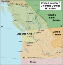
The Treaty of 1818 set the boundary between the United States and British North America along the 49th parallel of north latitude from Minnesota to the "Stony Mountains" [3] (now known as the Rocky Mountains). The region west of those mountains was known to the Americans as the Oregon Country and to the British as the Columbia Department or Columbia District of the Hudson's Bay Company. (Also included in the region was the southern portion of another fur district, New Caledonia.) The treaty provided for joint control of that land for ten years. Both countries could claim land and both were guaranteed free navigation throughout.

Original manuscript of the treaty (transcription), as kept by the U.S. National Archives. Oregon Treaty - NARA - 299808.pdf
Original manuscript of the treaty (transcription), as kept by the U.S. National Archives.

Joint control steadily grew less tolerable for both sides. After a British minister rejected the offer of U.S. Presidents James K. Polk and John Tyler to settle the boundary at the 49th parallel north, American expansionists called for the annexation of the entire region up to Parallel 54°40′ north, the southern limit of Russian America as established by parallel treaties between the Russian Empire and the United States (1824) and Britain (1825). However, after the outbreak of the Mexican–American War in April 1846 diverted U.S. attention and military resources, a compromise was reached in the ongoing negotiations in Washington, D.C., and the matter was then settled by the Polk administration (to the surprise of its own party's hardliners) to avoid a two-war situation, and another war with the formidable military strength of Great Britain. [4]

Senate vote in June 1846

In early June 1846 the British offered to negotiate the boundaries between the United States and British North America in the region west of the Rockies. Some US senators such as Charles Gordon Atherton and Benning Wentworth Jenness were combative and were in favor of rejecting British proposals to negotiate. However others, such as both Alabama senators (Arthur P. Bagby and Dixon Hall Lewis) as well as both Massachusetts senators (Daniel Webster and John Davis) were in favor of accepting British proposals. The Senate agreed that they would vote on whether or not to recommend President Polk accept British offers to negotiate. Watching closely, the British hoped this vote would pass the Senate. On June 12, the Senate voted 38–12 recommending that President Polk accept British proposals to negotiate this boundary. Votes in favor included 18 Democrats and 20 Whigs, whereas 11 Democrats and one Whig voted against. Three Democrats and three Whigs abstained. [5]

Negotiations

The treaty was negotiated by US Secretary of State James Buchanan and Richard Pakenham, British envoy to the United States. Foreign Secretary Earl of Aberdeen was responsible for it in Parliament. [6] The treaty was signed on June 15, 1846, ending the joint occupation and making Oregonians south of the 49th parallel American citizens, with those north of it becoming British. [7]

The Oregon Treaty set the border between the U.S. and British North America at the 49th parallel with the exception of Vancouver Island, which was retained in its entirety by the British. Vancouver Island, with all coastal islands, was constituted as the Colony of Vancouver Island in 1849. The U.S. portion of the region was organized as Oregon Territory on August 15, 1848, with Washington Territory being formed from it in 1853. The British portion remained unorganized until 1858, when the Colony of British Columbia was set up as a result of the Fraser Canyon Gold Rush and fears of the re-asserted American expansionist intentions. The two British colonies were amalgamated in 1866 as the Colony of British Columbia. When the Colony of British Columbia joined Canada in 1871, the 49th parallel and marine boundaries established by the Oregon Treaty became the Canada–US border.

In order to ensure that Britain retained all of Vancouver Island and the southern Gulf Islands, it was agreed that the border would swing south around that area. Ownership of several channel islands, including the San Juan Islands remained in dispute. A bloodless confrontation known as the Pig War erupted in 1859 over ownership of the San Juans, which was not resolved until 1872. Ultimately, arbitration began with German Emperor Wilhelm I as head of a three-man arbitration commission. [8] On October 21, 1872, the commission decided in favor of the United States, awarding the San Juan Islands to the U.S. [9]

Treaty definitions

The treaty states that the border in the Strait of Juan de Fuca would follow “the middle of the channel which separates the continent from Vancouver's Island.” It did not, however, specify which of several possible channels was intended, giving rise to ownership disputes over the San Juan Islands beginning in 1859.

Other provisions included:

Issues arising from treaty

Ambiguities in the wording of the Oregon Treaty regarding the route of the boundary, which was to follow "the deepest channel" out to the Strait of Juan de Fuca and beyond to the open ocean, resulted in the Pig War, another boundary dispute in 1859 over the San Juan Islands. The dispute was peacefully resolved after a decade of confrontation and military bluster during which the local British authorities consistently lobbied London to seize back the Puget Sound region entirely, as the Americans were busy elsewhere with the Civil War. [11] The San Juans dispute was not resolved until 1872 when, pursuant to the 1871 Treaty of Washington, an arbitrator (William I, German Emperor) chose the American-preferred marine boundary via Haro Strait, to the west of the islands, over the British preference for Rosario Strait which lay to their east.

The treaty also had the unintended consequence of putting what became Point Roberts, Washington on the "wrong" side of the border. A peninsula, jutting south from Canada into Boundary Bay, was made by the agreement, as land south of the 49th parallel, a separate fragment of the United States.

According to American historian Thomas C. McClintock, the British public welcomed the treaty:

Frederick Merk's statement that the "whole British press" greeted the news of the Senate's ratification of Lord Aberdeen's proposed treaty with "a sigh of relief" and "universal satisfaction" comes close to being accurate. The Whig, Tory, and independent newspapers agreed in their expressions of satisfaction with the treaty. Though a few newspapers had at least mild reservations, completely absent was the strong condemnation that had greeted the earlier Webster-Ashburton Treaty (which determined the northeast boundary between the United States and Canada). Lord Aberdeen had been determined to prevent such a response to the Oregon Treaty, and obviously he was extremely successful in doing so. [12]

See also

References and footnotes

  1. officially titled the Treaty between Her Majesty and the United States of America, for the Settlement of the Oregon Boundary and styled in the United States as the Treaty with Great Britain, in Regard to Limits Westward of the Rocky Mountains, and also known as the Buchanan-Pakenham (or Packenham) Treaty or (sharing the name with several other unrelated treaties) the Treaty of Washington
  2. David M. Pletcher, The Diplomacy of Annexation: Texas, Oregon, and the Mexican War. (U of Missouri Press, 1973).
  3. "Convention of Commerce between His Majesty and the United States of America.—Signed at London, 20th October 1818". Canado-American Treaties. Université de Montréal. 2000. Archived from the original on 11 April 2009. Retrieved 27 March 2006.
  4. Donald A. Rakestraw, For Honor or Destiny: The Anglo-American Crisis over the Oregon Territory (Peter Lang Publishing, 1995)
  5. "Voteview | Plot Vote: 29th Congress > Senate > 101".
  6. Churchill 1958
  7. Walker, Dale L. (1999). Bear Flag Rising: The Conquest of California, 1846 . New York: Macmillan. p.  60. ISBN   0312866852.
  8. "The Pig War". San Juan Island National Historical Park. National Park Service . Retrieved 13 January 2020.
  9. "Britain and the United States agree on the 49th parallel as the main Pacific Northwest boundary in the Treaty of Oregon on June 15, 1846". History Link. 13 July 2013. Retrieved 13 January 2020.
  10. "Treaty between Her Majesty and the United States of America, for the Settlement of the Oregon Boundary". Canado-American Treaties. Université de Montréal. 1999. Archived from the original on 13 November 2009. Retrieved 12 January 2007.
  11. James Robbins Jewell. "Thwarting Southern Schemes and British Bluster in the Pacific Northwest" (PDF). pp. 5–6.
  12. Thomas C. McClintock, "British newspapers and the Oregon Treaty of 1846." Oregon Historical Quarterly,(2003) 94#1 pp 96–109 at p. 96. online

Bibliography

Related Research Articles

<span class="mw-page-title-main">San Juan Islands</span> Archipelago in the Salish Sea in Washington, US

The San Juan Islands is an archipelago in the Pacific Northwest of the United States between the U.S. state of Washington and Vancouver Island, British Columbia, Canada. The San Juan Islands are part of Washington state, and form the core of San Juan County.

<span class="mw-page-title-main">Strait of Juan de Fuca</span> Strait between Vancouver Island and the Olympic Peninsula

The Strait of Juan de Fuca is a body of water about 96 miles long that is the Salish Sea's main outlet to the Pacific Ocean. The international boundary between Canada and the United States runs down the centre of the Strait.

<span class="mw-page-title-main">Manifest destiny</span> Cultural belief of 19th-century American expansionists

Manifest destiny was a phrase in the 19th-century United States that represented the belief that American settlers were destined to expand westward across North America, and that this belief was both obvious ("manifest") and certain ("destiny"). The belief was rooted in American exceptionalism and Romantic nationalism, implying the inevitable spread of the Republican form of governance. It was one of the earliest expressions of American imperialism in the United States of America.

<span class="mw-page-title-main">Treaty of Guadalupe Hidalgo</span> 1848 agreement ending the Mexican–American War

The Treaty of Guadalupe Hidalgo officially ended the Mexican–American War (1846–1848). It was signed on 2 February 1848 in the town of Guadalupe Hidalgo.

<span class="mw-page-title-main">Fort Vancouver</span> United States historic place

Fort Vancouver was a 19th century fur trading post that was the headquarters of the Hudson's Bay Company's Columbia Department, located in the Pacific Northwest. Named for Captain George Vancouver, the fort was located on the northern bank of the Columbia River in present-day Vancouver, Washington. The fort was a major center of the regional fur trading. Every year trade goods and supplies from London arrived either via ships sailing to the Pacific Ocean or overland from Hudson Bay via the York Factory Express. Supplies and trade goods were exchanged with a plethora of Indigenous cultures for fur pelts. Furs from Fort Vancouver were often shipped to the Chinese port of Guangzhou where they were traded for Chinese manufactured goods for sale in the United Kingdom. At its pinnacle, Fort Vancouver watched over 34 outposts, 24 ports, six ships, and 600 employees. Today, a full-scale replica of the fort, with internal buildings, has been constructed and is open to the public as Fort Vancouver National Historic Site.

<span class="mw-page-title-main">Point Roberts, Washington</span> Census-designated place in Washington, United States

Point Roberts is a pene-exclave of Washington on the southernmost tip of the Tsawwassen peninsula, south of Vancouver, British Columbia. The area, which had a population of 1,191 at the 2020 census, is reached by land from the rest of the United States by traveling 25 mi (40 km) through Canada. It is a census-designated place in Whatcom County, Washington, with a post office, and a ZIP Code of 98281. Direct sea and air connections with the rest of the U.S. are available across Boundary Bay.

<span class="mw-page-title-main">Adams–Onís Treaty</span> Treaty ceding Spanish Florida to the U.S. (1819)

The Adams–Onís Treaty of 1819, also known as the Transcontinental Treaty, the Spanish Cession, the Florida Purchase Treaty, or the Florida Treaty, was a treaty between the United States and Spain in 1819 that ceded Florida to the U.S. and defined the boundary between the U.S. and Mexico. It settled a standing border dispute between the two countries and was considered a triumph of American diplomacy. It came during the successful Spanish American wars of independence against Spain.

<span class="mw-page-title-main">Oregon Country</span> Early-19th-century U.S. fur trade district in North America

Oregon Country was a large region of the Pacific Northwest of North America that was subject to a long dispute between the United Kingdom and the United States in the early 19th century. The boundaries of the area, which had been created by the Treaty of 1818 without recognizing indigenous claims to the area, consisted of the land north of 42° N latitude, south of 54°40′ N latitude, and west of the Rocky Mountains down to the Pacific Ocean and east to the Continental Divide. Article III of the 1818 treaty gave joint control to both nations for ten years, allowed land to be claimed, and guaranteed free navigation to all mercantile trade. However, both countries disputed the terms of the international treaty. Oregon Country was the American name while the British used Columbia District for the region. Meanwhile, Indigenous nations had lived in the area since time immemorial, though with little legal recognition in the American and British legal systems. Evidence along the Salmon River shows people lived there at least 16,000 years ago, and may have populated the continent after migrating along the Pacific Coast, then following up the Columbia River into the interior.

The 49th parallel north is a circle of latitude that is 49° north of Earth's equator. It crosses Europe, Asia, the Pacific Ocean, North America, and the Atlantic Ocean.

<span class="mw-page-title-main">Pig War (1859)</span> Border dispute between the United States and the United Kingdom

The Pig War was a confrontation in 1859 between the United States and the United Kingdom over the British–U.S. border in the San Juan Islands, between Vancouver Island and the Washington Territory. The Pig War, so called because it was triggered by the shooting of a pig, is also called the Pig Episode, the Pig and Potato War, the San Juan Boundary Dispute, and the Northwestern Boundary Dispute. Despite being referred to as a "war", there were no human casualties on either side.

<span class="mw-page-title-main">Texas annexation</span> 1845 admission of Texas to the US

The Republic of Texas was annexed into the United States and admitted to the Union as the 28th state on December 29, 1845.

<span class="mw-page-title-main">Oregon boundary dispute</span> Early 19th century US–UK boundary dispute

The Oregon boundary dispute or the Oregon Question was a 19th-century territorial dispute over the political division of the Pacific Northwest of North America between several nations that had competing territorial and commercial aspirations in the region.

<span class="mw-page-title-main">Treaty of 1818</span> 1818 treaty which established the 49th parallel as the western US-Canada border

The Convention respecting fisheries, boundary and the restoration of slaves, also known as the London Convention, Anglo-American Convention of 1818, Convention of 1818, or simply the Treaty of 1818, is an international treaty signed in 1818 between the United States and the United Kingdom. This treaty resolved standing boundary issues between the two nations. The treaty allowed for joint occupation and settlement of the Oregon Country, known to the British and in Canadian history as the Columbia District of the Hudson's Bay Company, and including the southern portion of its sister district New Caledonia.

New Caledonia was a fur-trading district of the Hudson's Bay Company that comprised the territory of the north-central portions of present-day British Columbia, Canada. Though not a British colony, New Caledonia was part of the British claim to North America. Its administrative centre was Fort St. James. The rest of what is now mainland British Columbia was called the Columbia Department by the British, and the Oregon Country by the Americans. Even before the partition of the Columbia Department by the Oregon Treaty in 1846, New Caledonia was often used to describe anywhere on the mainland not in the Columbia Department, such as Fort Langley in the Fraser Valley.

<span class="mw-page-title-main">Quadra Island</span> Island in British Columbia, Canada

Quadra Island is a large island off the eastern coast of Vancouver Island, in British Columbia, Canada. It is part of the Discovery Islands, in the Strathcona Regional District.

<span class="mw-page-title-main">Columbia District</span> Fur trading district in British North America

The Columbia District was a fur trading district in the Pacific Northwest region of British North America in the 19th century. Much of its territory overlapped with the disputed Oregon Country. It was explored by the North West Company between 1793 and 1811, and established as an operating fur district around 1810. The North West Company was absorbed into the Hudson's Bay Company in 1821 under which the Columbia District became known as the Columbia Department. The Oregon Treaty of 1846 marked the effective end of the Hudson's Bay Company's Columbia Department.

<span class="mw-page-title-main">Colony of Vancouver Island</span> British crown colony (1849–1866)

The Colony of Vancouver Island, officially known as the Island of Vancouver and its Dependencies, was a Crown colony of British North America from 1849 to 1866, after which it was united with the mainland to form the Colony of British Columbia. The united colony joined Canadian Confederation, thus becoming part of Canada, in 1871. The colony comprised Vancouver Island and the Gulf Islands of the Strait of Georgia.

<span class="mw-page-title-main">Haro Strait</span> Navigable international boundary waterway connecting Juan de Fuca and Georgia Straits

The Haro Strait is one of the main channels connecting the Strait of Georgia to the Strait of Juan de Fuca, separating Vancouver Island and the Gulf Islands in British Columbia, Canada from the San Juan Islands of Washington state in the United States.

<span class="mw-page-title-main">Presidency of James K. Polk</span> U.S. presidential administration from 1845 to 1849

The presidency of James K. Polk began on March 4, 1845, when James K. Polk was inaugurated as President of the United States, and ended on March 4, 1849. He was a Democrat, and assumed office after defeating Whig Henry Clay in the 1844 presidential election. Polk left office after one term, fulfilling a campaign pledge he made in 1844, and he was succeeded by Whig Zachary Taylor. A close ally of Andrew Jackson, Polk's presidency reflected his adherence to the ideals of Jacksonian democracy and manifest destiny.

<span class="mw-page-title-main">History of U.S. foreign policy, 1829–1861</span>

The history of U.S. foreign policy from 1829 to 1861 concerns the foreign policy of the United States during the presidential administrations of Andrew Jackson, Martin Van Buren, William Henry Harrison, John Tyler, James K. Polk, Zachary Taylor, Millard Fillmore, Franklin Pierce, and James Buchanan. During this era, the United States annexed the Republic of Texas, acquired the Mexican Cession by defeating Mexico in the Mexican–American War and partitioned Oregon Country with the United Kingdom of Great Britain and Ireland. The period began with the inauguration of Jackson in 1829, while the onset of the American Civil War in 1861 marked the start of the next period in U.S. foreign policy.