John McLoughlin, baptized Jean-Baptiste McLoughlin, was a French-Canadian, later American, Chief Factor and Superintendent of the Columbia District of the Hudson's Bay Company at Fort Vancouver from 1824 to 1845. He was later known as the "Father of Oregon" for his role in assisting the American cause in the Oregon Country. In the late 1840s, his general store in Oregon City was famous as the last stop on the Oregon Trail.

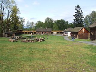
Fort Vancouver was a 19th-century fur trading post built in the winter of 1824–1825. It was the headquarters of the Hudson's Bay Company's Columbia Department, located in the Pacific Northwest. Named for Captain George Vancouver, the fort was located on the northern bank of the Columbia River in present-day Vancouver, Washington. The fort was a major center of the regional fur trading. Every year trade goods and supplies from London arrived either via ships sailing to the Pacific Ocean or overland from Hudson Bay via the York Factory Express. Supplies and trade goods were exchanged with a plethora of Indigenous cultures for fur pelts. Furs from Fort Vancouver were often shipped to the Chinese port of Guangzhou where they were traded for Chinese manufactured goods for sale in the United Kingdom. At its pinnacle, Fort Vancouver watched over 34 outposts, 24 ports, six ships, and 600 employees. Today, a full-scale replica of the fort, with internal buildings, has been constructed and is open to the public as Fort Vancouver National Historic Site.

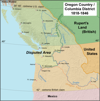
Oregon Country was a large region of the Pacific Northwest of North America that was subject to a long dispute between the United Kingdom and the United States in the early 19th century. The area, which had been demarcated by the Treaty of 1818, consisted of the land north of 42° N latitude, south of 54°40′ N latitude, and west of the Rocky Mountains down to the Pacific Ocean and east to the Continental Divide. Article III of the 1818 treaty gave joint control to both nations for ten years, allowed land to be claimed, and guaranteed free navigation to all mercantile trade. However, both countries disputed the terms of the international treaty. Oregon Country was the American name, while the British used Columbia District for the region.
The Oregon boundary dispute or the Oregon Question was a 19th-century territorial dispute over the political division of the Pacific Northwest of North America between several nations that had competing territorial and commercial aspirations in the region.

The history of British Columbia covers the period from the arrival of Paleo-Indians thousands of years ago to the present day. Prior to European colonization, the lands encompassing present-day British Columbia were inhabited for millennia by a number of First Nations.

Sir James Douglas, was a Canadian fur trader and politician who became the first Governor of the Colony of British Columbia. He is often credited as "The Father of British Columbia". He was instrumental to the resettlement of 35 African Americans fleeing a life of racial persecution in San Francisco who arrived in the province aboard the steamship Commodore in what later became known as the Pioneer Committee. In 1863, Douglas was knighted by Queen Victoria for his services to the Crown.

Fort Victoria began as a fur trading post of the Hudson's Bay Company and was the headquarters of HBC operations in the Columbia District, a large fur trading area now part of the province of British Columbia, Canada and the U.S. state of Washington. Construction of Fort Victoria in 1843 highlighted the beginning of a permanent British settlement now known as Victoria, the capital city of British Columbia. The fort itself was demolished in November 1864 as the town continued to grow as a commercial centre serving the local area as well as trading with California, Washington Territory, the United Kingdom, and others.
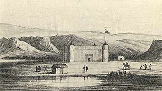
The trade center Fort Colvile was built by the Hudson's Bay Company (HBC) at Kettle Falls on the Columbia River in 1825 and operated in the Columbia fur district of the company. Named for Andrew Colvile, a London governor of the HBC, the fort was a few miles west of the present site of Colville, Washington. It was an important stop on the York Factory Express trade route to London via the Hudson Bay. The HBC for some time considered Fort Colvile second in importance only to Fort Vancouver, near the mouth of the Columbia, until the foundation of Fort Victoria.

The Columbia District was a fur-trading district in the Pacific Northwest region of North America, in both the United States and British North America in the 19th century. Much of its territory overlapped with the temporarily jointly occupied and disputed Oregon Country. It was explored by the North West Company between 1793 and 1811 and established as an operating fur-trading district around 1810. The North West Company was absorbed into the Hudson's Bay Company (HBC) in 1821, under which the Columbia District became known as the Columbia Department. It was considered part of British North America and later became the brief first Colony of British Columbia (1858–1866) with the subsequent merger with the Colony of Vancouver Island (1849–1866) to form a larger second short-lived Colony of British Columbia (1866–1871). After protracted negotiations with British and Canadian authorities, the newly reorganized Province of British Columbia joined in 1871 with the new Canadian confederation of 1867 further east, as the western-most province of the now trans-continental Dominion of Canada. The Oregon Treaty of June 1846, signed in Washington, D.C., by the United States and the United Kingdom, marked the effective end of the old Hudson's Bay Company's jurisdiction of the former western Columbia District / Department on the Pacific coast, although the HBC still continues a mercantile commercial business into the 21st century.

The Colony of Vancouver Island, officially known as the Island of Vancouver and its Dependencies, was a Crown colony of British North America from 1849 to 1866, after which it was united with the mainland to form the Colony of British Columbia. The united colony joined Canadian Confederation, thus becoming part of Canada, in 1871. The colony comprised Vancouver Island and the Gulf Islands of the Strait of Georgia.
The Colony of British Columbia was a British Crown Colony that resulted from the 1866 merger of two British colonies, the Colony of Vancouver Island and the mainland Colony of British Columbia. The united colony existed until its incorporation into Canadian Confederation in 1871 as the Province of British Columbia.
Fort Nez Percés, later known as (Old) Fort Walla Walla, was a fortified fur trading post on the Columbia River on the territory of modern-day Wallula, Washington. Despite being named after the Nez Perce people, the fort was in the traditional lands of the Walla Walla. Founded in 1818 by the North-West Company, after 1821 it was run by the Hudson's Bay Company until its closure in 1857.
Fort Langley National Historic Site, commonly shortened to Fort Langley, is a former fur trading post of the Hudson's Bay Company in the community of Fort Langley of Langley, British Columbia, Canada. The national historic site sits above the banks of the Bedford Channel across McMillan Island. The national historic site contains a visitor centre and a largely reconstructed trading post that contains ten structures surrounded by wooden palisades.

Oregon pioneer history (1806–1890) is the period in the history of Oregon Country and Oregon Territory, in the present day state of Oregon and Northwestern United States.
The Puget Sound Agricultural Company (PSAC), with common variations of the name including Puget Sound or Puget's Sound, was a subsidiary joint stock company formed in 1840 by the Hudson's Bay Company (HBC). Its stations operated within the Pacific Northwest, in the HBC administrative division of the Columbia Department. The RAC-HBC Agreement was signed in 1839 between the Russian-American Company and the HBC, with the British to now supply the various trade posts of Russian America. It was hoped by the HBC governing committee that independent American merchants, previously a major source of foodstuffs for the RAC, would be shut out of the Russian markets and leave the Maritime fur trade.
The Hudson's Bay Brigade Trail, sometimes referred to simply as the Brigade Trail, refers to one of two routes used by Hudson's Bay Company fur traders to transport furs, goods and supplies between coastal and Columbia District headquarters at Fort Vancouver and those in New Caledonia and also in Rupert's Land. Importantly the route was that used by the annual "Hudson's Bay Express", a shipment of the company books and profits to company headquarters.

The York Factory Express, usually called "the Express" and also the Columbia Express and the Communication, was a 19th-century fur brigade operated by the Hudson's Bay Company (HBC). Roughly 4,200 kilometres (2,600 mi) in length, it was the main overland connection between HBC headquarters at York Factory and the principal depot of the Columbia Department, Fort Vancouver.

James Sinclair was a trader and explorer with the Hudson's Bay Company (HBC). He twice led large parties of settlers from the Red River Colony to the Columbia River valley. These were both authorized by the HBC as a part of grandiose plans to strengthen British claims in the Oregon boundary dispute.
Fort Stikine was a fur trade post and fortification in what is now the Alaska Panhandle, at the site of the present-day of Wrangell, Alaska. Originally built as the Redoubt San Dionisio or Redoubt Saint Dionysius in 1834, the site was transferred to the British-owned Hudson's Bay Company as part of a lease signed in the region in 1838, and renamed Fort Stikine when turned into a Hudson's Bay Company post in 1839. The post was closed and decommissioned by 1843 but the name remained for the large village of the Stikine people which had grown around it, becoming known as Shakesville in reference to its ruling Chief Shakes by the 1860s. With the Alaska Purchase of 1867, the fortification became occupied by the US Army and was renamed Fort Wrangel, a reference to Baron von Wrangel, who had been Governor of Russian America when the fort was founded. The site today is now part of the city of Wrangell.
The Douglas Treaties, also known as the Vancouver Island Treaties or the Fort Victoria Treaties, were a series of treaties signed between a number of First Nations of Vancouver Island and the Colony of Vancouver Island.