
Prince George is a city in British Columbia, Canada, with a city population of 76,708 and a metro census agglomeration population of 89,490. It is often called the province's "northern capital". It is situated at the confluence of the Fraser and Nechako rivers.
Highway 16 is a highway in British Columbia, Canada. It is an important section of the Yellowhead Highway, a part of the Trans-Canada Highway that runs across Western Canada. The highway closely follows the path of the northern B.C. alignment of the Canadian National Railway. The number "16" was first given to the highway in 1941, and originally, the route that the highway took was more to the north of today's highway, and it was not as long as it is now. Highway 16 originally ran from New Hazelton east to Aleza Lake. In 1947, Highway 16's western end was moved from New Hazelton to the coastal city of Prince Rupert, and in 1953, the highway was re-aligned to end at Prince George. In 1969, further alignment east into Yellowhead Pass was opened to traffic after being constructed up through 1968 and raised to all-weather standards in 1969. Highway 16's alignment on Haida Gwaii was commissioned in 1983 and is connected to the mainland segment via BC Ferries route #11.
McBride is a village in the Robson Valley region of British Columbia, Canada. The village is located 210 km (130 mi) southeast of Prince George, British Columbia, and 166 km (103 mi) west of Jasper, Alberta. Incorporated in 1932, McBride is located in the Robson Valley surrounded by the Rocky Mountains and Cariboo Ranges.

The Grand Trunk Pacific Railway was a historic Canadian transcontinental railway running from Fort William, Ontario to Prince Rupert, British Columbia, a Pacific coast port. East of Winnipeg the line continued as the National Transcontinental Railway (NTR), running across northern Ontario and Quebec, crossing the St. Lawrence River at Quebec City and ending at Moncton, New Brunswick. The Grand Trunk Railway (GTR) managed and operated the entire line.

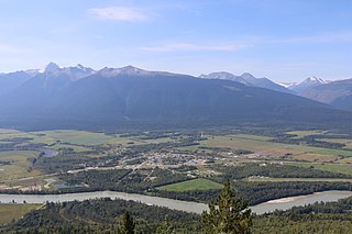
Smithers is a town in northwestern British Columbia, approximately halfway between Prince George and Prince Rupert. With a population of 5,351 in 2016, Smithers provides service coverage for most of the Bulkley Valley.
Vanderhoof is a district municipality near the geographical centre of British Columbia, Canada. Covering 2.92 square kilometers., it has a population of about 4,500 within town limits, and offers services to nearly 10,000 people in nearby rural communities. Its main industries are forestry, agriculture, and related businesses. Tourism is also growing, and mining operations are being developed in the area. It has many elementary schools, and one major secondary school, Nechako Valley Secondary School (NVSS), comprising School District 91 Nechako Lakes. The College of New Caledonia has a regional campus there.

Stuart Lake, or Nak'albun in the Carrier (Dakelh) language is a lake situated in the Northern Interior of British Columbia, Canada. The town of Fort St. James is situated by the lake near the outlet. Stuart Lake is 66 kilometres (41 mi) long, 10 kilometres (6.2 mi) wide and relatively shallow, with an average depth of 26 metres (85 ft).
McLeod Lake is an unincorporated community located on Highway 97 in northern British Columbia, Canada, 140 km (87 mi) north of Prince George. It is notable for being the first continuously inhabited European settlement established west of the Rocky Mountains in present-day Canada.
Stuart River Provincial Park is a provincial park in British Columbia, Canada. It is located in two sections north and northwest of Vanderhoof along the Stuart River southeast of Stuart Lake and the city of Fort St. James. The upper section is located at 54°13′20″N124°00′00″W and comprises c.7391 ha. while the lower, eastern section is centred at 54°03′00″N123°37′00″W and comprises c.3390 ha. and is within the Greater Prince George area. The upper site, which is located around the confluence of the Stuart and Nechako Rivers, includes the site of Chinlac, a Dakelh village whose inhabitants were massacred and enslaved by the Tsilhqot'in of Anahim Lake c. 1745.

Fraser Lake is a village in northern British Columbia, Canada. It's located on the southwest side of Fraser Lake between Burns Lake and Vanderhoof alongside the Yellowhead Highway.
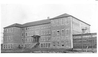
Lejac Residential School was a Canadian residential school in British Columbia that operated from 1922 to 1976 by the Roman Catholic Church under contract with the Government of Canada.

Northern Health is the publicly funded healthcare provider for the northern half of the Canadian province of British Columbia. Northern Health serves over 300,000 people in an area of 600,000 square kilometres. It was established as one of five geographically based health authorities in 2001 by the Government of British Columbia.

The College of New Caledonia (CNC) is a post-secondary educational institution that serves the residents of the Central Interior of British Columbia. This region has a population of about 145,000, and it encompasses three school districts: #28 (Quesnel), #57 (Prince George), and #91 (Nechako Lakes). CNC operates six campuses in Prince George, Burns Lake, Fort St. James, Mackenzie, Quesnel and Vanderhoof.
New Hazelton is a district municipality on Highway 16 in northwest British Columbia, Canada. It is situated 133 km (83 mi) northeast of Terrace and 68 km (42 mi) northwest of Smithers and in 2016 had a population of 580 people, a decrease of 12.9% comparing to 2011. New Hazelton is one of the "Three Hazeltons", the other two being the original "Old" Hazelton located 6 km (4 mi) to the northwest very near to the confluence of the Skeena and Bulkley Rivers and South Hazelton, 5 km (3 mi) to the west.

The Last Spike of the Grand Trunk Pacific Railway was driven one mile east of Fort Fraser, British Columbia, Canada on April 7, 1914.

Nicolas Coccola was a French Oblate missionary in British Columbia, Canada from 1880 until his death in 1943.
The Nechako Region is the second-largest economic development region in British Columbia and covers an area of 200,023 km2, from the Nechako plateau, in central British Columbia, northward to the border with Yukon Territory.
Fort St. James is a district municipality and former fur trading post in northern central British Columbia, Canada. It is located on the south-eastern shore of Stuart Lake in the Omineca Country, at the northern terminus of Highway 27, which connects to Highway 16 at Vanderhoof.
Lejac is a locality on the Canadian National Railway line in the Nechako Country region of British Columbia, located on the south shore of Fraser Lake between the communities of Fraser Lake (W) and Fort Fraser (E).

BC Bus North is a public intercity bus service created by the Province of British Columbia after Greyhound Canada cancelled all services in British Columbia, leaving the Highway 16 and Highway 97 corridors without passenger transportation options. In its first month of operation, June 2018, the service saw 300 riders, while its second month saw an increase to 450 riders. While BC Transit does not operate BC Bus North or share branding, BC Bus North is listed as a public transit system by BC Transit.

