Assiniboine River fur trade

Last updated

Fur trading on the Assiniboine River and the general area west of Lake Winnipeg, in what is now Manitoba, Canada, began as early as 1731.

Contents

Geography

Assiniboine River Assiniboinerivermap.png
Assiniboine River

Lake Winnipeg was a major junction for the fur trade routes. See Canadian canoe routes (early). To the southeast the route ran to Grand Portage and the French center at Montreal. To the northeast the Hayes River led to the English base on Hudson Bay. To the northwest the Saskatchewan River led west to the Rocky Mountains. From this river another route led northwest to the even richer Athabasca Country.

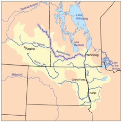
West of Lake Winnipeg is the chain of lakes that look like a single lake on large maps (Cedar Lake (Manitoba), Lake Winnipegosis and Lake Manitoba). West of this is the Assiniboine River. The Assiniboine flows southeast and then the east to Winnipeg, Manitoba where it meets the Red River of the North which flows north into Lake Winnipeg. Further west the Qu'Appelle River flows east to meet the Assiniboine. South of the Qu'Appelle is the Souris River which was not important in the fur trade. East of the upper Assiniboine the Swan River almost reaches the Assiniboine and flows into Lake Winnipegosis. To the southwest is the Mandan country on the upper Missouri. There was some overland trade with the Mandans until the Americans took it over around 1812. North of Lake Winnipeg is the so-called Muskrat Country which was of some importance around 1800.

The Assiniboine is mostly a prairie river and was not a good source of beaver. It mainly produced buffalo pemmican to feed the voyageurs further north. Because much of the Assiniboine is shallow and crooked, horses, dog sleds and later carts were used in addition to canoes. Most of the beaver came from the forests on the upper Assiniboine. This area was most easily reached via the Swan River from Lake Winnipegosis.

History

French Period

In 1691 Henry Kelsey reached the upper Assiniboine from Hudson Bay. In 1731, La Vérendrye began pushing French trade and exploration west from Lake Superior. He built Fort Maurepas (Canada) at the mouth of the Red River (1734), Fort Rouge (1738) at Winnipeg and Fort La Reine (1738) on the Assiniboine south of Lake Manitoba. Explorers were sent to the Mandan country and as far as Wyoming. When it became apparent the Assiniboine was not a route to the Pacific attention shifted north to the Saskatchewan River (Fort de la Corne, 1753). The French diverted much trade away from Hudson Bay to Montreal. The English responded by sending agents inland. In 1756-58 Joseph Smith and Joseph Waggoner made two trips to the Swan River and upper Assiniboine.

English Period

The western fur trade collapsed during the British conquest of Canada but it was soon restored by English-speakers. These so-called "Pedlars" joined together to form the North West Company. The Hudson's Bay Company responded by building posts inland, starting with Cumberland House, Saskatchewan in 1774. Competition between the HBC and NWC led to a great expansion to trade and exploration until the merger of the two companies in 1821. Pedlars reached Lake Winnipeg by 1767 and Fort des Épinettes west of Lake Manitoba in 1768. By the 1770s they were on the lower Saskatchewan River. The NWC reached the Swan River in 1787 and in the 1790s many posts were built on the upper Assiniboine. In 1787 the NWC built Fort Espérance on the Qu'Appelle River. In the 1790s Brandon House and Fort Montagne à la Bosse were built on the middle Assiniboine and there was trade from this area with the Mandans. In 1805 there was communication between the Assiniboine posts and the Lewis and Clark Expedition. In 1811 the Red River Colony was founded which led to open violence culminating in the Battle of Seven Oaks in 1816. After 1821, when the two companies merged, the upper Assiniboine posts were closed and trade concentrated at Fort Pelly at the Swan River portage. In 1831 Fort Ellice was built at the mouth of the Qu'Appelle River and later became more important that Fort Pelly. The Carlton Trail gradually evolved as an overland route west from Winnipeg. By around 1870 St. Paul, Minnesota had a population of 120,000 while there were 11,963 inhabitants on Manitoba. There was a 450-mile cart trail from St. Paul to Winnipeg. Railroads and settlers arrived in the 1880s.

List of trading posts

Posts on the Assiniboine and lower Red River Distances are approximate straight-line distances from the previous entry.

distancepostyearsownernotes
0 Fort Maurepas 1734-39Frenchmouth of the Red River at Lake Winnipeg
32kmS Lower Fort Garry 1830-1911HBC
32kmSSW Fort Rouge 1738-49FrenchAssiniboine joins the Red River
0 Fort Gibraltar 1809-21NWC
0 Fort Douglas 1809-12HBC
0 Upper Fort Garry 1832-1989HBCbecomes Winnipeg city
80kmW Fort La Reine 1738-?Frenchportage north to Lake Manitoba
75kmWSW Fort des Épinettes 1768-1811NWCalso "Pine Fort"
35kmWNW Brandon House 1793-1824HBC,NWCmouth of the Souris River; "Fort Assiniboine", "Fort la Souris"
80kmW Fort Montagne à la Bosse 1790-1805NWCriver turns east
75kmNNW Fort Ellice 1831-99HBCmouth of Qu'Appelle River
110kmN Fort de la Rivière Tremblante 1791-98NWC"Aspin House","Grant's House"
50kmN Fort Pelly 1824-1924HBCportage east to Swan River
c40kwNWUpper Assiniboine posts1793-1821NWC,HBCSee Upper Assiniboine and Swan River below
Canada Manitoba relief location map.jpg
Dot-yellow.svg
Maurepas
Red pog.svg
Lower FG
Dot-yellow.svg
Upper FG
Dot-yellow.svg
La Reine
Red pog.svg
Brandon
Red pog.svg
Bosse
Red pog.svg
Ellice
Red pog.svg
Aspin
Red pog.svg
Pelly
Red pog.svg
Pembina
Location dot blue.svg
Red Deer
Location dot blue.svg
Swan River
Location dot blue.svg
Cumberland House
Location dot blue.svg
York Factory
Assiniboine River trading posts
Yellow=French foundation;
Blue=not on Red/Assiniboine Rivers

Upper Assiniboine and Swan River fur trade

Assiniboine River Trading Posts AssiniboineRiverTradingPosts.jpg
Assiniboine River Trading Posts

From before 1787 until 1821 there were a number of trading posts on the upper Assiniboine and Swan River. Either they are ill-documented or the documents have not been studied, so there is little information and locations are uncertain. [8] Because the upper Assiniboine is shallow, twisting and full of sand bars the area was usually reached via the Swan River. The route ran from Lake Winnipegosis up the short Shoal River to Swan Lake, up the Swan River to its bend and over an easy portage to the Assiniboine near the later Fort Pelly. Because the area was much closer to Hudson Bay than Montreal the Hudson's Bay Company had a significant advantage over the North West Company.

The first in the area was William Bruce, an independent trader from Montreal. He established an unnamed post in the Shoal River at an uncertain date. In 1787 Robert Grant of the North West Company built Swan River Fort (NWC,1787-?) on the north bank of the Swan River ten or twelve miles above Swan Lake. In 1790 Charles Isham of the Hudson's Bay Company built Swan River House (HBC,1790-1808) one-half mile above the NWC post. About 1793 the NWC built a post between the Swan and Assiniboine in response to Marlboro House below.

In 1793 Isham built Marlboro House (HBC,1793-?) on the Assiniboine near its "elbow" which is near the Swan River portage and the later Fort Pelly. In 1793 Cuthbert Grant of the NWC built Bird Mountain House (NWC,1793-?) 50 miles upstream at the mouth of Thunder Creek. In 1794 Isham built Somerset House (HBC, 1794-1808) two miles above Grant's post. This was in an area used as a wintering place by buffalo and was so successful that it reduced Swan River House to an outpost. In 1795 the NWC built posts immediately next to Swan River House and Somerset House (Losey does not explain what happened to the NWC posts already nearby.) About the same time Isham and Peter Fidler built a post 15 miles west of the elbow which they called Carlton House (HBC,1795?-?) (not to be confused with Fort Carlton). In 1795 the NWC built Fort Alexandria (NWC 1795-1821), said to be near Sturgis, Saskatchewan. Daniel Williams Harmon was here from 1800 to 1805. It was closed 1805 and re-opened in 1807. John Sutherland built Albany House (HBC,1796-?) after moving up from the Shell River. There were also some "South Men" who came from the area around Duluth, but they are very poorly documented. The area soon became trapped out. The HBC closed Swan River House and Somerset House some time between 1799 and 1807 and briefly reopened them for the 1807-08 season with Peter Fidler in charge. The NWC continued to operate but all the posts were closed in 1821 when the two companies merged. The general area continued to be called "Swan River District" and was administered from Fort Pelly from 1824.

Related Research Articles

<span class="mw-page-title-main">Pierre Gaultier de Varennes, sieur de La Vérendrye</span> 18th-century French Canadian military officer, fur trader and explorer

Pierre Gaultier de Varennes, sieur de La Vérendrye was a French Canadian military officer, fur trader, and explorer. In the 1730s, he and his four sons explored the area west of Lake Superior and established trading posts there. They were part of a process that added Western Canada to the original New France territory that was centred along the Saint Lawrence basin.

<span class="mw-page-title-main">Assiniboine River</span> River in the Canadian provinces of Saskatchewan and Manitoba

The Assiniboine River is a 1,070-kilometre (660 mi) river that runs through the prairies of Western Canada in Saskatchewan and Manitoba. It is a tributary of the Red River. The Assiniboine is a typical meandering river with a single main channel embanked within a flat, shallow valley in some places and a steep valley in others. Its main tributaries are the Qu'Appelle, Souris and Whitesand Rivers. For early history and exploration see Assiniboine River fur trade.

<span class="mw-page-title-main">Winnipeg River</span> River in the Canadian provinces of Manitoba and Ontario

The Winnipeg River is a Canadian river that flows roughly northwest from Lake of the Woods in the province of Ontario to Lake Winnipeg in Manitoba. This river is 235 kilometres (146 mi) long from the Norman Dam in Kenora to its mouth at Lake Winnipeg. Its watershed is 106,500 square kilometres (41,100 sq mi) in area, mainly in Canada. About 29,000 square kilometres (11,000 sq mi) of the watershed is in northern Minnesota, United States.

<span class="mw-page-title-main">Henry Kelsey</span> English explorer and fur trader

Henry Kelsey was an English fur trader, explorer, and sailor who played an important role in establishing the Hudson's Bay Company in Canada.

Fort Espérance was a North West Company trading post near Rocanville, Saskatchewan from 1787 until 1819. It was moved three times and was called Fort John from 1814 to 1816. There was a competing XY Company post from 1801 to 1805 and a Hudson's Bay post nearby from 1813 to 1816. It was on the Qu'Appelle River about 20 km from that river's junction with the Assiniboine River and about 7 km west of the Manitoba border. It was on the prairie in buffalo country and was mainly used as a source of pemmican which was sent down the river to Fort Bas de la Rivière at the mouth of the Winnipeg River.

<span class="mw-page-title-main">Fort La Reine</span>

Fort La Reine was built in 1738 and is one of the forts of the western expansion directed by Pierre Gaultier de Varennes et de La Vérendrye, first military commander in the west of what is now known as Canada. Located on the Assiniboine River where present day Portage la Prairie, Manitoba, stands, the fort served as a fur trading post. It was also the base of operations for much exploration north and west. From Fort La Reine, explorers made their way to Lake Manitoba and Lake Winnipegosis, Lake Winnipeg and the Saskatchewan River.

Fort Ellice was a Hudson's Bay Company trading post that operated from 1794 to 1892. It was first established in February 1794 by John Sutherland on the Qu'Appelle River about 20 kilometres (12 mi) upstream from its mouth at the Assiniboine River, and known as the Qu'Appelle River Post until it was destroyed by the North West Company in 1816.

<span class="mw-page-title-main">Selkirk Concession</span> 1812 land grant issued by the Hudsons Bay Company

The Selkirk Concession was a land grant issued by the Hudson's Bay Company (HBC) to Thomas Douglas, 5th Earl of Selkirk, in 1812. The Hudson's Bay Company held a commercial monopoly in Rupert's Land, consisting of the entire Hudson Bay drainage basin. The Selkirk Concession, also known as Selkirk's Grant, included a large section of the southwest area of Rupert's Land, bounded: on the north by the line of 52° N latitude roughly from the Assiniboine River east to Lake Winnipegosis, then by the line of 52° 30′ N latitude from Lake Winnipegosis to Lake Winnipeg; on the east by the Winnipeg River, Lake of the Woods and Rainy River; on the west roughly by the current boundary between modern Saskatchewan and Manitoba; and on the south by the rise of land marking the extent of the Hudson Bay watershed. This covered portions of present-day southern Manitoba, northern Minnesota and eastern North Dakota, in addition to small parts of eastern Saskatchewan, northwestern Ontario and northeastern South Dakota.

<span class="mw-page-title-main">Peter Fidler</span> British surveyor, map-maker, fur trader and explorer

Peter Fidler was a British surveyor, map-maker, fur trader and explorer who had a long career in the employ of the Hudson's Bay Company (HBC) in what later became Canada. He was born in Bolsover, Derbyshire, England and died at Fort Dauphin in present-day Manitoba. He married Mary (Methwewin) Mackagonne, a Cree woman, and together they had 14 children.

<span class="mw-page-title-main">Fort Pelly</span> Fort, Military Structure, fur trading post in Saskatchewan, Canada

Fort Pelly was a Hudson's Bay Company fur trading post located in the Canadian province of Saskatchewan. The fort was named after Sir John Pelly, governor of the Hudson's Bay Company. The current village of Pelly, Saskatchewan, takes its name from the fort, and is located approximately 8 miles north of the site of the fort.

Touchwood Hills Post Provincial Park is the location of a former Hudson's Bay Company (HBC) fur trading post that existed from 1879 to 1909 in the Touchwood Uplands of the Canadian province of Saskatchewan. In 1986, the site was designated a provincial park. It is located along Highway 15 in the RM of Kellross No. 247, about 10 kilometres (6.2 mi) west of Lestock and 16 kilometres (9.9 mi) east of Punnichy.

<span class="mw-page-title-main">Bas de la Rivière</span>

Bas de la Rivière is a geographical area on both sides of the Winnipeg River at and near the mouth where it empties into Lake Winnipeg. It had a storied historical period in the opening of the west and the subsequent fur trade and settlement.

<span class="mw-page-title-main">Canadian canoe routes</span> Canoe routes of early explorers of Canada

This article covers the water based Canadian canoe routes used by early explorers of Canada with special emphasis on the fur trade.

<span class="mw-page-title-main">Saskatchewan River fur trade</span>

Saskatchewan River fur trade The Saskatchewan River was one of the two main axes of Canadian expansion west of Lake Winnipeg. The other and more important one was northwest to the Athabasca Country. For background see Canadian canoe routes (early). The main trade route followed the North Saskatchewan River and Saskatchewan River, which were just south of the forested beaver country. The South Saskatchewan River was a prairie river with few furs.

Pedlar is a term used in Canadian history to refer to English-speaking independent fur traders from Montreal who competed with the Hudson's Bay Company in western Canada from about 1770 to 1803. After 1779 they were mostly absorbed by the North West Company. The name was first used by the Hudson's Bay Company to refer to French coureurs des bois, who travelled inland to trade with the Indians in their villages and camps. This was in contrast to the HBC policy of building posts on Hudson Bay, to where the Indians would bring furs to trade with them.

Brandon House was a Hudson's Bay Company post or posts from 1793 to 1824. It was located at several places on the Assiniboine River between Brandon, Manitoba and the mouth of the Souris River about 21 miles southeast of Brandon. Because of its location near the Souris River it was a center for trade with the Mandans in North Dakota. It was moved four times and there were related forts nearby, so its history is necessarily complex. For background see Assiniboine River fur trade.

Asleep by the frozen sea is a phrase coined by Joseph Robson to describe the policy of the Hudson's Bay Company (HBC) from its foundation in 1670 until the establishment of its first inland post in 1774. Unlike the French who sent Coureurs des bois inland to trade, the HBC built posts on Hudson Bay and waited for the Indians to bring furs to them. The decision to abandon this policy and move inland gradually turned the HBC into an informal government for western Canada and led ultimately to the confederation of western and eastern Canada.

The Iron Confederacy or Iron Confederation was a political and military alliance of Plains Indians of what is now Western Canada and the northern United States. This confederacy included various individual bands that formed political, hunting and military alliances in defense against common enemies. The ethnic groups that made up the Confederacy were the branches of the Cree that moved onto the Great Plains around 1740, the Saulteaux, the Nakoda or Stoney people also called Pwat or Assiniboine, and the Métis and Haudenosaunee. The Confederacy rose to predominance on the northern Plains during the height of the North American fur trade when they operated as middlemen controlling the flow of European goods, particularly guns and ammunition, to other Indigenous nations, and the flow of furs to the Hudson's Bay Company (HBC) and North West Company (NWC) trading posts. Its peoples later also played a major part in the bison (buffalo) hunt, and the pemmican trade. The decline of the fur trade and the collapse of the bison herds sapped the power of the Confederacy after the 1860s, and it could no longer act as a barrier to U.S. and Canadian expansion.

<span class="mw-page-title-main">Pemmican War</span> Conflict between the Hudsons Bay Company and North West Company from 1812 to 1821

The Pemmican War was a series of armed confrontations during the North American fur trade between the Hudson's Bay Company (HBC) and the North West Company (NWC) in the years following the establishment of the Red River Colony in 1812 by Lord Selkirk. It ended in 1821 when the NWC merged with the HBC.

References

  1. Kavanagh,page 59
  2. Kavanagh, page 18
  3. Martin Kavanagh, "The Assiniboine Basin", 1946, page 69
  4. Kavanagh, page 44 quoting Peter Fidler's report of May 1819
  5. Kavanagh, page 37
  6. Kavanagh, page 57
  7. Kavanagh, page 24
  8. This section is from Elizabeth Browne Losey,"Let Them be Remembered: The Story of the Fur Trade Forts", 1999, page 129-133. The author, who is usually exact, is vague in this one area. Arthur Morton, "A History of Western Canada", circa 1936, is equally vague.