Longhunter

Last updated
Longhunter
Daniel Boone engraving.png
Daniel Boone, one of the most famous longhunters, on the early American frontier
Occupation
NamesLonghunter, long hunter
Description
CompetenciesTrapping, hunting, fishing, skinning, marksmanship, self-defense, trading, canoeing, horsemanship, tracking, exploring, mental and physical toughness, wilderness survival skills, folk medicine, frontier doctoring, diplomacy, English, French, Spanish, and Native American languages
Related jobs
Coureur des bois, Mountain man
Longhunter with dead deer Longhunter Drawing Accession Number SHS 000800 From The State Historical Society of Missouri.png
Longhunter with dead deer

A longhunter (or long hunter) was an 18th-century explorer and hunter who made expeditions into the American frontier for as much as six months at a time.

Contents

While historian Emory Hamilton says that "The Long Hunter was peculiar to Southwest Virginia only...", many also hailed from North Carolina's western piedmont. [1] The term has also been used loosely to describe any unofficial European American explorer of the period. Many long hunts started in the Holston River Valley near Chilhowie, Virginia. Parties of men usually started their hunts in October and ended toward the end of March or early in April, going west into the territory of present-day Kentucky and Tennessee. These were the hunting grounds of the Cherokee and Shawnee people. [1]

The longhunters gathered information about the western lands in the 1760s and early 1770s that would prove critical to early European American settlement in Tennessee and Kentucky. Many longhunters were employed by land surveyors seeking to claim new lands ceded to the British by the French in the Ohio River Valley following France's defeat in the Seven Years' War. Some later helped guide settlers to what became Middle Tennessee and southeastern Kentucky.

History

Reconstructed "lean-to" at the longhunter camp demonstration area at Bledsoe's Fort Historic Park in Sumner County, Tennessee Bledsoe-longhunter-camp-tn1.jpg
Reconstructed "lean-to" at the longhunter camp demonstration area at Bledsoe's Fort Historic Park in Sumner County, Tennessee

Tennessee

As colonial settlement approached the eastern base of the Appalachian Mountains in the early 18th century, game in the Piedmont region became more scarce. Merchants returning from trade missions to Overhill Cherokee villages in the Tennessee Valley brought back news of the abundance of game west of the range and began taking hunters along on their trade expeditions. In 1748 and 1750, Thomas Walker crossed the mountains and explored the Holston River valley, recording and widely publicizing the location of Cumberland Gap a pass near the modern border of Virginia, Kentucky, and Tennessee. This allowed relatively easy access to the headwaters of the Tennessee and Cumberland rivers, by which travelers could enter the territories downriver. [2]

In 1761, Elisha Wallen (spelled variously "Walden", "Wallin", and "Walling") led the first major recorded long hunt into what is now Tennessee. Wallen set up a station camp in Lee County, Virginia, and trekked into the Clinch and Powell valleys in what is now Hawkins County, Tennessee. That same year, Colonel Adam Stephen led regiments of Virginia and North Carolina soldiers to Long Island of the Holston, in what is now Sullivan County, Tennessee. The expedition was to act in conjunction with a combined British and South Carolina force commanded by Lieutenant Colonel James Grant (British Army officer, born 1720). Grant's force destroyed 18 Cherokee towns, ending the Anglo-Cherokee War before Stephen's campaign could get underway. [3] [4]

With the end of the Seven Years' War in 1763, the French ceded their claims to lands east of the Mississippi River to Great Britain. After the Anglo-Cherokee War, longhunters (some of whom may have been veterans of Stephen's expedition) began crossing the Appalachians into Tennessee and Kentucky in greater numbers. In 1764, Daniel Boone, Richard Callaway and Benjamin Cutbirth explored the upper Holston Valley as agents for Richard Henderson, a land speculator who later played an important role in the early settlement of Tennessee. [5] [6] One of their camps later was used by Boone's friend William Bean, Tennessee's first known permanent Euro-American settler. He built a cabin at the site around 1769. [7]

King George III issued the Royal Proclamation of 1763 prohibiting colonists from encroaching on Native lands. This effectively barred hunting west of the Appalachian range. Both the Cherokee and the British, however, had considerable difficulty enforcing this ban. In 1769, Cherokee Chief Oconastota complained to the British Superintendent of Indian Affairs that the entire Cherokee Nation was "filling with Hunters, and the guns rattling every way on the path." [8] While some longhunters had their pelts confiscated by the Cherokee, and a rare few were even killed, most managed to avoid detection. [9]

Stones River Stones-river-long-hunter-tn1.jpg
Stones River

In 1766 James Smith (frontiersman) led an ambitious long hunt into Middle, West Tennessee, and Kentucky, following the Cumberland River all the way to its mouth on the Ohio River (in present-day, Kentucky). While a member of this expedition, Uriah Stone, was hunting along a tributary of the Cumberland a colonial French hunting companion stole all his furs. The tributary was subsequently named Stones River. [10] Stone returned to the Cumberland valley in 1769, along with fellow hunters Kasper Mansker, Isaac and Abraham Bledsoe, Joseph Drake, and Robert Crockett. Although Crockett was killed that year, the 1766 and 1769 expeditions identified various trails, salt licks, and camping areas that later helped guide the first Anglo-American settlers to the Middle Tennessee area. [11]

Legacy

Various geographical entities in Tennessee are named for longhunters. Walden Ridge, the eastern escarpment of the Cumberland Plateau in Tennessee, is named for Elisha Wallen, one of the first Anglo-Americans to observe it. [12] A high school and dozens of geographical features in Tennessee have been named for Boone, whose exploits came to symbolize frontier life in Tennessee and Kentucky. Isaac Bledsoe was the namesake of Bledsoe Creek in Sumner County, Tennessee, now the site of Bledsoe Creek State Park. [13] Isaac's brother, Anthony, later became the namesake for Bledsoe County. [14]

In 1780, Mansker built a frontier station in what is now Goodlettsville, just north of Nashville. In 1986, the city of Goodlettsville built a replica of Mansker's Station (it is based on historic examples, as the fort's original layout is unknown). It is now open to the public. In the 1970s, Tennessee established Long Hunter State Park along the J. Percy Priest Lake impoundment of Stones River, in the area where Uriah Stone had his furs stolen more than 200 years earlier.

Kentucky

1852 painting of Squire Boone crossing the mountains Squire Boone Crossing the Mountains with Stores for His Brother Daniel.jpg
1852 painting of Squire Boone crossing the mountains

The end of King George's War in 1748 left control of the territory between the Appalachian Mountains and the Mississippi River in dispute. The French wanted the region to connect their holdings in Canada with Illinois Country and New Orleans, and the British sought to establish a foothold in the Ohio Valley. French commander Pierre-Joseph Celoron de Blainville conducted maneuvers in 1749 that discouraged British trade west of the Appalachians, although American colonial land speculators remained interested in the region. Walker's 1750 expedition briefly explored what is now southeastern Kentucky, and explorer Christopher Gist managed to reach the mouth of the Kentucky River in 1751. [15]

In the opening years of the French and Indian War, the French gained control of the Ohio Valley with the defeat of George Washington at Fort Necessity in 1754. With the fall of Fort Duquesne and the construction of Fort Pitt in 1758, however, the French were forced to evacuate the region. The French departure and a relative state of peace with the Cherokee during the same period opened up the region to explorers and hunters from the Thirteen Colonies. [16]

John and Samuel Pringle, two deserters from Fort Pitt, spent much of the early 1760s hunting in the Tygart Valley and likely ranged into what is now Kentucky. Part of Elisha Walden's 1761 party hunted along the Rockcastle River from their station camp in southwestern Virginia. In 1767, an expedition led by James Harrod and Michael Holsteiner (Michael Stoner) crossed Kentucky from north to south, reaching the Nashville area several weeks after departing from the Illinois Country. Around the same time, an expedition led by Benjamin Cutbirth crossed Cumberland Gap and pushed all the way to the Mississippi River, where they shipped the pelts they had collected down to New Orleans. [17]

In 1768, John Finley passed through the Yadkin Valley and visited Daniel Boone, with whom he had served in the French and Indian War. Finley told Boone of the natural splendor of Kentucky's Bluegrass region, which he had visited as a merchant before the French and Indian War. The following year, the two led an expedition into Kentucky, traveling up the Rockcastle River and establishing a station camp at Red Lick Fork. While Boone and his companion John Stuart were hunting along the Kentucky River, they were captured by the Shawnee, and their pelts were confiscated. They returned to their station camp to find it plundered and learned that Finley and the rest of the expedition had returned to North Carolina. Undeterred, Boone and Stuart continued hunting in the region. Boone was later joined by his brother, Squire, and the Boone brothers remained in the Kentucky wilderness until 1771. Although they again had their pelts confiscated when they were intercepted by the Cherokee at Cumberland Gap, the Boones were nevertheless eager to return to settle in the region. [18] Daniel Boone's vivid accounts of his hunting exploits helped draw a flood of settlers to Kentucky in subsequent years.

Legacy

Numerous natural and political entities in Kentucky bear the names of longhunters, including Boone County and Boonesborough, named for Daniel Boone, and Harrodsburg, named for James Harrod. Kenton County is named for Simon Kenton, who, believing he was a fugitive, spent the mid-1770s hunting in eastern Kentucky. Longhunter James Knox named the Dix River after Cherokee leader Captain Dick, who gave Knox permission to hunt along the river in 1770. [19] The U.S. government established Daniel Boone National Forest in 1937 in the eastern part of the state.

Notable people

Related Research Articles

<span class="mw-page-title-main">Daniel Boone</span> American pioneer and frontiersman (1734–1820)

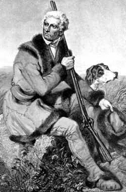
Daniel Boone was an American pioneer and frontiersman whose exploits made him one of the first folk heroes of the United States. He became famous for his exploration and settlement of Kentucky, which was then beyond the western borders of the Thirteen Colonies. In 1775, Boone blazed the Wilderness Road through the Cumberland Gap and into Kentucky, in the face of resistance from American Indians, for whom the area was a traditional hunting ground. He founded Boonesborough, one of the first English-speaking settlements west of the Appalachian Mountains. By the end of the 18th century, more than 200,000 people had entered Kentucky by following the route marked by Boone.

<span class="mw-page-title-main">Elizabethton, Tennessee</span> City in Tennessee, United States

Elizabethton is a city in, and the county seat of Carter County, Tennessee, United States. Elizabethton is the historical site of the first independent American government located west of both the Eastern Continental Divide and the original Thirteen Colonies.

<span class="mw-page-title-main">Transylvania Colony</span> Short-lived extra-legal colony in frontier Kentucky

The Transylvania Colony, also referred to as the Transylvania Purchase, was a short-lived, extra-legal colony founded in early 1775 by North Carolina land speculator Richard Henderson, who formed and controlled the Transylvania Company. Henderson and his investors had reached an agreement to purchase a vast tract of Cherokee lands west of the southern and central Appalachian Mountains through the acceptance of the Treaty of Sycamore Shoals with most leading Cherokee chieftains then controlling these lands. In exchange for the land the tribes received goods worth, according to the estimates of some scholars, about 10,000 British pounds. To further complicate matters, this frontier land was also claimed by the Virginia Colony and a southern portion by Province of North Carolina.

<span class="mw-page-title-main">Ridge-and-Valley Appalachians</span> Physiographic province of the larger Appalachian division

The Ridge-and-Valley Appalachians, also called the Ridge and Valley Province or the Valley and Ridge Appalachians, are a physiographic province of the larger Appalachian Highlands division. The physiographic province is divided into three sections: the Hudson Valley, the Central, and the Tennessee.

<span class="mw-page-title-main">East Tennessee</span> Geographic region of Tennessee

East Tennessee is one of the three Grand Divisions of Tennessee defined in state law. Geographically and socioculturally distinct, it comprises approximately the eastern third of the U.S. state of Tennessee. East Tennessee consists of 33 counties, 30 located within the Eastern Time Zone and three counties in the Central Time Zone, namely Bledsoe, Cumberland, and Marion. East Tennessee is entirely located within the Appalachian Mountains, although the landforms range from densely forested 6,000-foot (1,800 m) mountains to broad river valleys. The region contains the major cities of Knoxville and Chattanooga, Tennessee's third and fourth largest cities, respectively, and the Tri-Cities, the state's sixth largest population center.

<span class="mw-page-title-main">James Robertson (explorer)</span> Explorer and pioneer, born 1742

James Robertson was an American explorer, soldier and Indian agent, and one of the founding fathers of what became the State of Tennessee. An early companion of explorer Daniel Boone, Robertson helped establish the Watauga Association in the early 1770s, and to defend Fort Watauga from an attack by Cherokee in 1776. In 1779, he co-founded what is now Nashville, and was instrumental in the settlement of Middle Tennessee. He served as a brigadier general in the Southwest Territory militia in the early 1790s, and as an Indian Commissioner in later life.

<span class="mw-page-title-main">Wilderness Road</span> Historic highway in Kentucky, US

The Wilderness Road was one of two principal routes used by colonial and early national era settlers to reach Kentucky from the East. Although this road goes through the Cumberland Gap into southern Kentucky and northern Tennessee, the other is sometimes called the "Cumberland Road" because it started in Fort Cumberland in Maryland. Despite Kentucky Senator Henry Clay's advocacy of this route, early in the 19th century, the northern route was selected for the National Road, connecting near Washington, Pennsylvania into the Ohio Valley of northern Kentucky and Ohio.

<span class="mw-page-title-main">Overmountain Men</span> American frontiersmen from west of the Appalachian Mountains

The Overmountain Men were American frontiersmen from west of the Blue Ridge Mountains which are the leading edge of the Appalachian Mountains, who took part in the American Revolutionary War. While they were present at multiple engagements in the war's southern campaign, they are best known for their role in the American victory at the Battle of Kings Mountain in 1780. The term "overmountain" arose because their settlements were west of, or "over", the Blue Ridge, which was the primary geographical boundary dividing several of the 13 American states from the Native American lands to the west. The Overmountain Men hailed from parts of Virginia, North Carolina, and what is now Tennessee and Kentucky.

Kasper Mansker or Casper Mansker also, spelled Mäintzger and Minsker (1750–1820) was a longhunter and one of Middle Tennessee's first European explorers and settlers.

<span class="mw-page-title-main">History of Kentucky</span>

The prehistory and history of Kentucky span thousands of years, and have been influenced by the state's diverse geography and central location. Archaeological evidence of human occupation in Kentucky begins approximately 9,500 BCE. A gradual transition began from a hunter-gatherer economy to agriculture c. 1800 BCE. Around 900 CE, the Mississippian culture took root in western and central Kentucky; the Fort Ancient culture appeared in eastern Kentucky. Although they had many similarities, the Fort Ancient culture lacked the Mississippian's distinctive, ceremonial earthen mounds.

<span class="mw-page-title-main">Sycamore Shoals</span> River rapids along the Watauga River in Elizabethton, Tennessee, US

The Sycamore Shoals of the Watauga River, usually shortened to Sycamore Shoals, is a rocky stretch of river rapids along the Watauga River in Elizabethton, Tennessee. Archeological excavations have found Native Americans lived near the shoals since prehistoric times, and Cherokees gathered there. As Europeans began settling the Trans-Appalachian frontier, the shoals proved strategic militarily, as well as shaped the economies of Tennessee and Kentucky. Today, the shoals are protected as a National Historic Landmark and are maintained as part of Sycamore Shoals State Historic Park.

Powell Mountain is a mountain ridge of the Ridge-and-valley Appalachians of the Appalachian Mountains. It is a long and narrow ridge, running northeast to southwest, from about Norton, Virginia, to near Tazewell, Tennessee. It separates the Clinch River basin and the Powell River basin of Powell Valley. It was named for an 18th-century explorer.

<span class="mw-page-title-main">Cherokee–American wars</span> Indian wars in the Old Southwest

The Cherokee–American wars, also known as the Chickamauga Wars, were a series of raids, campaigns, ambushes, minor skirmishes, and several full-scale frontier battles in the Old Southwest from 1776 to 1794 between the Cherokee and American settlers on the frontier. Most of the events took place in the Upper South region. While the fighting stretched across the entire period, there were extended periods with little or no action.

<span class="mw-page-title-main">Great Indian Warpath</span> Trails in eastern North America used by Native Americans

The Great Indian Warpath (GIW)—also known as the Great Indian War and Trading Path, or the Seneca Trail—was that part of the network of trails in eastern North America developed and used by Native Americans which ran through the Great Appalachian Valley. The system of footpaths extended from what is now upper New York to deep within Alabama. Various Native peoples traded and made war along the trails, including the Catawba, numerous Algonquian tribes, the Cherokee, and the Iroquois Confederacy. The British traders' name for the route was derived from combining its name among the northeastern Algonquian tribes, Mishimayagat or "Great Trail", with that of the Shawnee and Delaware, Athawominee or "Path where they go armed".

<span class="mw-page-title-main">Sycamore Shoals State Historic Area</span> State park in Elizabethton, Tennessee, USA

Sycamore Shoals State Historic Area is a state park located in Elizabethton, in the U.S. state of Tennessee. The park consists of 70 acres (28.3 ha) situated along the Sycamore Shoals of the Watauga River, a National Historic Landmark where a series of events critical to the establishment of the states of Tennessee and Kentucky, and the settlement of the Trans-Appalachian frontier in general, took place. Along with the historic shoals, the park includes a visitor center and museum, the reconstructed Fort Watauga, the Carter House and Sabine Hill . For over a thousand years before the arrival of European explorers, Sycamore Shoals and adjacent lands had been inhabited by Native Americans. The first permanent European settlers arrived in 1770, and established the Watauga Association—one of the first written constitutional governments west of the Appalachian Mountains—in 1772. Richard Henderson and Daniel Boone negotiated the Treaty of Sycamore Shoals in 1775, which saw the sale of millions of acres of Cherokee lands in Kentucky and Tennessee and led to the building of the Wilderness Road. During the American Revolution, Sycamore Shoals was both the site of Fort Watauga, where part of a Cherokee invasion was thwarted in 1776, and the mustering ground for the Overmountain Men in 1780.

<span class="mw-page-title-main">Bledsoe's Station</span> United States historic place

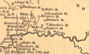
Bledsoe's Station, also known as Bledsoe's Fort, was an 18th-century fortified frontier settlement located in what is now Castalian Springs, Tennessee. The fort was built by longhunter and Sumner County pioneer Isaac Bledsoe in the early 1780s to protect Upper Cumberland settlers and migrants from hostile Native American attacks. While the fort is no longer standing, its location has been verified by archaeological excavations. The site is now part of Bledsoe's Fort Historical Park, a public park established in 1989 by Sumner County residents and Bledsoe's descendants.

<span class="mw-page-title-main">Bledsoe Creek State Park</span> State-protected area of Tennessee, United States

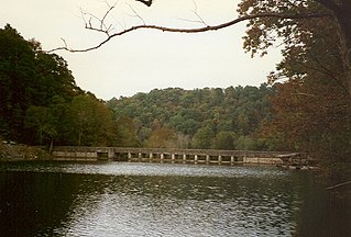
Bledsoe Creek State Park is a state park in Sumner County, Tennessee, in the southeastern United States. The park consists of 169 acres (0.68 km2) managed by the Tennessee Department of Environment and Conservation. The park spans much of the west shore of the Bledsoe Creek embayment of Old Hickory Lake, an impoundment of the Cumberland River created with the completion of Old Hickory Dam by the U.S. Army Corps of Engineers in 1954.

<span class="mw-page-title-main">Moccasin Gap</span>

Moccasin Gap, also known as Big Moccasin Gap, is a pass in Clinch Mountain, a long ridge within the Appalachian Mountains, at Gate City, Virginia. This gap has a long history as a passageway through the mountain. It was used by the Cherokee and Shawnee, and was the first gap through which the Daniel Boone Wilderness Road passed on its way to the better-known Cumberland Gap and Kentucky. Today it serves as a primary commercial route for industry, retail, and tourism businesses.

Henry Skaggs was an American longhunter, explorer and pioneer, active primarily on the frontiers of Tennessee and Kentucky during the latter half of the 18th century. His career as an explorer began as early as 1761 as one of the so-called long hunters— men who undertook lengthy hunting expeditions into the Trans-Allegheny wilderness. In subsequent years, working as a land agent with Richard Henderson and Daniel Boone, he explored large parts of Middle Tennessee and Central Kentucky. Skaggs led a pursuit and failed attempt to apprehend America's first known serial killers, the Harpe Brothers in 1799.

<span class="mw-page-title-main">Mansker's Station</span>

Mansker's Station, also called Mansker's Fort was a station along Avery's Trace in Middle Tennessee. It was built by Kasper Mansker.

References

  1. 1 2 Emory L. Hamilton. Historical Sketches of Southwest Virginia 5: The Long Hunters (Wise, VA: Historical Society of Southwest Virginia, March 1970)
  2. J.G.M. Ramsey. The Annals of Tennessee (Johnson City, TN: Overmountain Press, 1999), 65-66.
  3. Philip Hamer, Tennessee: A History, 1673-1932 (New York: The American Historical Society, 1933), 62-64.
  4. Ramsey, The Annals of Tennessee, 67-68.
  5. Ramsey, The Annals of Tennessee, 66-69.
  6. Hamer, Tennessee: A History, 64.
  7. Carolyn Sakowski, Touring the East Tennessee Backroads (Winston-Salem, N.C.: J.F. Blair, 1993), 86-87.
  8. Paul Bergeron, et al. Tennesseans and their History (Knoxville, Tenn.: University of Tennessee Press, 1999), 20.
  9. Bergeron, et al., Tennesseans and their History, 19-20.
  10. Hamer, Tennessee: A History, 65.
  11. Ramsey, The Annals of Tennessee, pp. 96-97.
  12. The WPA Guide to Tennessee (Knoxville: University of Tennessee Press, 1986), 480. Originally compiled by the Federal Writers' Project of the Works Project Administration as Tennessee: A Guide to the State, and published in 1939.
  13. Walter Durham. "Isaac Bledsoe." The Tennessee Encyclopedia of History and Culture, 2009. Retrieved: 11 February 2013.
  14. Elizabeth Robnett. "Bledsoe County." The Tennessee Encyclopedia of History and Culture, 2009. Retrieved: 11 February 2013.
  15. The WPA Guide to Kentucky (Lexington: University Press of Kentucky, 1996), 36. Originally compiled in 1939 by the Federal Writers' Project of the Works Projects Administration.
  16. Otis Rice, Frontier Kentucky (Lexington: University Press of Kentucky, 1993), 15-16.
  17. Rice, 20-23.
  18. Rice, 24-28.
  19. Rice, 24.
  20. Collins' Historical Sketches of Kentucky, Collins & Co. 1874

Further reading