Sullivan County, Tennessee

Last updated

Sullivan County
Sullivan-county-courthouse-tn1.jpg
Sullivan County Courthouse in Blountville
Map of Tennessee highlighting Sullivan County.svg
Location within the U.S. state of Tennessee
Tennessee in United States.svg
Tennessee's location within the U.S.
Coordinates: 36°31′N82°18′W / 36.51°N 82.3°W / 36.51; -82.3
CountryFlag of the United States.svg United States
StateFlag of Tennessee.svg  Tennessee
Founded1779
Named for General John Sullivan [1]
Seat Blountville
Largest city Kingsport
Government
  County Mayor Richard Venable (R)
Area
  Total430 sq mi (1,100 km2)
  Land413 sq mi (1,070 km2)
  Water16 sq mi (40 km2)  3.8%
Population
 (2020)
  Total158,163 Increase2.svg
  Density379/sq mi (146/km2)
Time zone UTC−5 (Eastern)
  Summer (DST) UTC−4 (EDT)
Congressional district 1st
Website sullivancountytn.gov

Sullivan County is a county located in the U.S. state of Tennessee on its northeast border. As of the 2020 census, the population was 158,163. [2] Its county seat is Blountville. [3]

Contents

Sullivan County is part of the KingsportBristol TN-VA Metropolitan Statistical Area, which is a component of the Kingsport Johnson City Bristol, TN-VA Combined Statistical Area, commonly known as the "Tri-Cities" region.

Sullivan is Tennessee's second-oldest county; [4] it was established in 1779 when the area was still part of North Carolina. From 1784 to 1788, it was part of the extra-legal State of Franklin. [5]

History

Sullivan County was created in 1779 from a portion of Washington County, and named for John Sullivan, a Patriot general in the Revolutionary War. [6] Long Island of the Holston in Kingsport was long an important center for the Cherokee, who occupied much of this territory. Later in 1761 the British colonists built Fort Robinson on Long Island, following the fall of Fort Loudoun further to the south. This attracted other settlers, and the Sullivan area became one of the earliest areas of Tennessee to be settled by European Americans. [1]

As political tensions rose prior to the American Civil War, Sullivan County was one of the few East Tennessee counties to support secession. It became known as the Little Confederacy. In Tennessee's June 1861 referendum, the county voted 1,586 to 627 in favor of secession. [7]

Geography

According to the U.S. Census Bureau, the county has a total area of 430 square miles (1,100 km2), of which 413 square miles (1,070 km2) is land and 16 square miles (41 km2) (3.8%) is water. [8] The western portion of the county lies within the Ridge-and-Valley Appalachians, which are characterized by long, narrow ridges roughly oriented northeast-to-southwest. The northeastern end of Bays Mountain, part of the Ridge-and-Valley range, rises southwest of Kingsport. The eastern portion of the county lies within the Blue Ridge Mountains. [9] Holston Mountain, which at 4,284 feet (1,306 m) is the highest point in Sullivan, straddles the county's eastern boundary with Johnson County.

In Kingsport, the South Fork Holston River and the North Fork Holston River join to form the Holston River, one of the tributaries of the Tennessee River. The Watauga River, a tributary of the South Fork Holston, forms part of Sullivan's boundary with Washington County to the south. The North Fork Holston forms part of Sullivan's boundary with Hawkins County to the west. Fort Patrick Henry Dam and Boone Dam both create large artificial lakes along the South Fork Holston southeast of Kingsport.

Blountville, Sullivan's county seat, is Tennessee's only unincorporated county seat.

Morrell Cave

Morrell Cave (also known as Worleys Cave) is a Tennessee State Natural Area. The cave has a surveyed length of 4.4 miles (7.1 km), making it the second-longest cave in East Tennessee and the 177th longest cave in the United States. [10] [11] Morrell Cave is located on the south side of the Holston River, 2.5 miles (4.0 km) east of Bluff City.

During the Civil War, the cave was a major source of saltpeter, the main ingredient of gunpowder. Significant evidence of this mining activity remains in the cave, including evidence of large amounts of saltpeter-bearing dirt having been removed, pick marks in the dirt, and an elaborate system of trails used by the miners. Cave historian Marion O. Smith has determined that two companies of the Confederate Nitre and Mining Bureau, District No. 7, were active in Sullivan County. [12]

Adjacent counties and independent city

National protected areas

State protected areas

Other protected areas

Major highways

Demographics

Historical population
CensusPop.Note
1800 10,218
1810 6,847−33.0%
1820 7,0152.5%
1830 10,07343.6%
1840 10,7366.6%
1850 11,7429.4%
1860 13,55215.4%
1870 13,136−3.1%
1880 18,32139.5%
1890 20,87914.0%
1900 24,93519.4%
1910 28,12012.8%
1920 36,25928.9%
1930 51,08740.9%
1940 69,08535.2%
1950 95,06337.6%
1960 114,13920.1%
1970 127,32911.6%
1980 143,96813.1%
1990 143,596−0.3%
2000 153,0486.6%
2010 156,8232.5%
2020 158,1630.9%
U.S. Decennial Census [13]
1790-1960 [14] 1900-1990 [15]
1990-2000 [16] 2010-2019 [2]
Age pyramid Sullivan County USA Sullivan County, Tennessee.csv age pyramid.svg
Age pyramid Sullivan County

2020 census

Sullivan County racial composition [18]
RaceNumberPercentage
White (non-Hispanic)143,35490.64%
Black or African American (non-Hispanic)3,1972.02%
Native American 3500.22%
Asian 1,2700.8%
Pacific Islander 360.02%
Other/Mixed 6,4084.05%
Hispanic or Latino 3,5482.24%

As of the 2020 United States census, there were 158,163 people, 68,560 households, and 44,284 families residing in the county.

2010 census

As of the 2010 United States Census, there were 156,281 people living in the county. 95.5% were White, 0.6% Black or African American, 0.4% Asian, 0.2% Native American, 2.2% of some other race and 1.0% of two or more races. 4.8% were Hispanic or Latino (of any race).

2000 census

As of the census [19] of 2000, there were 153,048 people, 63,556 households, and 44,806 families living in the county. The population density was 371 people per square mile (143 people/km2). There were 69,052 housing units at an average density of 167 units per square mile (64/km2). The racial makeup of the county was 96.55% White, 1.89% Black or African American, 0.22% Native American, 0.43% Asian, 0.01% Pacific Islander, 0.21% from other races, and 0.69% from two or more races. 0.71% of the population were Hispanic or Latino of any race.

There were 63,556 households, out of which 28.40% had children under the age of 18 living with them, 57.10% were married couples living together, 10.20% had a female householder with no husband present, and 29.50% were non-families according to the United States Census Bureau. Of 63,556 households, 1,915 are unmarried partner households: 1,702 heterosexual, 97 same-sex male, 116 same-sex female. 26.40% of all households were made up of individuals, and 11.10% had someone living alone who was 65 years of age or older. The average household size was 2.36 and the average family size was 2.84.

In the county, the population was spread out, with 21.80% under the age of 18, 7.30% from 18 to 24, 28.40% from 25 to 44, 26.50% from 45 to 64, and 15.90% who were 65 years of age or older. The median age was 40 years. For every 100 females, there were 93.30 males. For every 100 females age 18 and over, there were 90.20 males.

The median income for a household in the county was $33,529, and the median income for a family was $41,025. Males had a median income of $31,204 versus $21,653 for females. The per capita income for the county was $19,202. About 9.70% of families and 12.90% of the population were below the poverty line, including 17.10% of those under age 18 and 11.90% of those age 65 or over.

Government

Sullivan County, like all of Tennessee outside Nashville and Memphis, is heavily Republican, but, unlike most of East Tennessee, has not voted consistently Republican since the Civil War. Being one of only six counties in East Tennessee and the only county in Northeast Tennessee to support the Confederacy, Sullivan County mostly voted Democratic between the end of the Civil War and the mid-20th century, the only county in the northern two-thirds of East Tennessee to do so. The last Democratic presidential candidate to carry Sullivan County was southerner Jimmy Carter in 1976.

Richard Venable is the county mayor. The county commission has 24 members. [20] Before 2010, commissioners were elected on a nonpartisan basis, but Sullivan County's commission election became a partisan election in 2010 after the county Republican Party decided to conduct a primary election for commission seats. [21] The county elections also cover Circuit Court Judges, Chancellor, Criminal Court Judge, District Attorney General, Public Defender, County Trustee, General Session Judge, Sherriff, Circuit Court Clerk, County Clerk, Register of Deeds, Commissioner of Highways, County Attorney, and School Board.

United States presidential election results for Sullivan County, Tennessee [22] [23]
Year Republican Democratic Third party
No.%No.%No.%
2020 55,86075.12%17,27223.23%1,2251.65%
2016 46,97975.43%12,57820.20%2,7214.37%
2012 43,56272.74%15,32125.58%1,0041.68%
2008 44,80870.02%18,35428.68%8351.30%
2004 42,55567.94%19,63731.35%4470.71%
2000 33,48260.08%21,35438.32%8911.60%
1996 29,29654.42%20,57138.21%3,9707.37%
1992 28,80150.55%20,93536.74%7,24412.71%
1988 32,99664.73%17,39634.13%5851.15%
1984 36,51667.83%16,92531.44%3940.73%
1980 25,96351.44%22,34144.27%2,1664.29%
1976 22,08747.23%23,35349.94%1,3222.83%
1972 27,59371.64%10,00725.98%9172.38%
1968 20,25150.60%9,78324.44%9,99124.96%
1964 17,70347.59%19,49652.41%00.00%
1960 22,35459.46%14,73139.18%5131.36%
1956 18,90356.42%14,10642.10%4971.48%
1952 15,59656.58%11,84942.99%1180.43%
1948 6,98446.19%7,62650.44%5103.37%
1944 5,22345.24%6,29054.49%310.27%
1940 4,15336.36%7,23463.34%340.30%
1936 3,49235.65%6,26964.00%340.35%
1932 2,99935.52%5,32263.04%1211.43%
1928 4,14956.33%3,21643.67%00.00%
1924 2,24739.95%3,31358.90%651.16%
1920 3,59345.37%4,32754.63%00.00%
1916 1,77640.51%2,60159.33%70.16%
1912 53812.72%2,41357.07%1,27730.20%
1908 1,83643.09%2,39356.16%320.75%
1904 1,50641.06%2,11657.69%461.25%
1900 1,73941.25%2,42157.42%561.33%
1896 1,91442.70%2,51256.05%561.25%
1892 1,30433.26%2,28158.17%3368.57%
1888 1,51339.36%2,25558.66%761.98%
1884 1,29836.98%2,17661.99%361.03%
1880 1,20734.77%2,26465.23%00.00%

Current composition of the Sullivan County Commission

DistrictMemberLocation
District 1David Hayes (2022- )Bristol, TN
District 2David AkardBristol, TN
Cheryl Harvey (2022- )Bristol, TN
Matt Slagle (2022- )Bristol, TN
District 3Andrew CrossBristol, TN
District 4Michael ColeBlountville, TN
Joyce CrosswhiteBlountville, TN
Tony LeonardBristol, TN
District 5Hershel GloverBluff City, TN
Dwight KingsPiney Flats, TN
District 6Daniel Horne (2022- )Kingsport, TN
Jessica Crowder Means (2022- )Kingsport, TN
Zane Vanover (2022- )Kingsport, TN
District 7Sam JonesKingsport, TN
Travis Ward (2022 - )Kingsport, TN
District 8Darlene CaltonKingsport, TN
Mark Ireson (2022- )Kingsport, TN
District 9Joe Carr (2022- )Kingsport, TN
Joseph McMurray (2022- )Kingsport, TN
District 10Larry CrawfordKingsport, TN
Gary StidhamKingsport, TN
District 11John GardnerKingsport, TN
Hunter LockeKingsport, TN
Archie PierceKingsport, TN

2022

The primary election took place on May 3, 2022, with the general election concurring with the State/Federal general election on August 4. The following incumbents did not run for re-election, Randy C. Morrell (District 1), Mark Hutton (District 2), and Judy Blalock (District 6). Angie Stanley retired from her seat in District 7 to unsuccessfully challenge incumbent mayor Richard Veneable in a primary. Both of the incumbents from District 9 (Downton Kingsport, Tennessee, retired, Collette George (who also serves on the Kingsport BMA [her son was running for county mayor]) and Doug Woods.

Incumbents who lost re-election

The following incumbents lost re-nomination: District 2 - Mark Vance (ran for county mayor, dropped out, lost renomination) District 6 - Todd Broughton (placed 4th in top 3 advance) District 6 - Terry Harkleroad (placed 6th in top 3 advance)

No incumbents lost re-election in the general election. Most races were uncontested (the republicans were the only ones on the ballot), except District 7 in which Lori Love (wife of perennial candidate Avril Love, and Democratic State Executive Committeewoman) garnered 15% of the vote, and District 9, Independent Candidate Randall Bowers garnered 15% if the vote.

Sherriff

Sullivan County Sherriff Jeff Cassidy first ran for the position in 2018 as an independent beating out controversial Republican Wayne Anderson. He ran for re-election in 2022 as a Republican. Alongside Circuit Court Judge District 2, Part I, John S. McLellan III, who was serving as a Democrat, by changing both of their political affiliations to Republican in this election, they have effectively ended

County Mayoral Election

The election for County Mayor was between incumbent Richard S. Veneable (Republican), Val Edwards George (Independent [Conservative]), and Bobby Weaver (Independent [Conservative])

2021 Mayoral Election
PartyCandidateVotes%
Republican Richard Veneable (incumbent) 5,162 66.26
NonpartisanVal Edwards George1,96725.25
NonpartisanBobby Weaver6618.49
Total votes7,790 100

Law enforcement

The Sullivan County Sheriffs Office has a staff of 260 deputies, corrections officers, and support personnel. The department also staffs a 24-7 9-1-1 dispatch center that provides dispatching for the sheriff's office, Bluff City Police Department, Sullivan County Fire Departments, and Sullivan County EMS. The dispatch center receives approximately 100,000 calls each year. [24]

As of 2022 the sheriff is Jeff Cassidy, who won election in 2018 after a very contentious race against previous sheriff Wayne Anderson. [25] Anderson apologized after sending text messages to a corrections employee that threatened to fire anyone who voted for his opponent, Jeff Cassidy, and saying that department employees would urinate on Cassidy's grave. [26]

A 2022 lawsuit claims that sheriff's deputies retaliated against a woman who had asked them to wear face masks due to the COVID-19 pandemic. [27]

Since the organization was established, 10 members of the sheriff's office have died in the line of duty. [28]

Communities

Cities

Census-designated places

Unincorporated communities

Education

The three school districts are Bristol Tennessee City Schools, Kingsport City School District, and Sullivan County School District. [29]

Notable people

See also

Related Research Articles

<span class="mw-page-title-main">Washington County, Virginia</span> County in Virginia, United States

Washington County is a county located in the Commonwealth of Virginia. As of the 2020 census, the population was 53,935. Its county seat is Abingdon.

<span class="mw-page-title-main">Washington County, Tennessee</span> County in Tennessee, United States

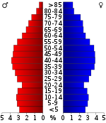
Washington County is a county located in the U.S. state of Tennessee. As of the 2020 census, the population was 133,001. Its county seat is Jonesborough. The county's largest city and a regional educational, medical and commercial center is Johnson City. Washington County is Tennessee's oldest county, having been established in 1777 when the state was still part of North Carolina. Washington County is part of the Johnson City, TN Metropolitan Statistical Area, which is a component of the Johnson City–Kingsport–Bristol, TN-VA Combined Statistical Area, commonly known as the "Tri-Cities" region.

<span class="mw-page-title-main">Unicoi County, Tennessee</span> County in Tennessee, United States

Unicoi County is a county located in the U.S. state of Tennessee. As of the 2020 census, the population was 17,928. Its county seat is Erwin. Unicoi is a Cherokee word meaning "white," "hazy," "fog-like," or "fog draped," and refers to the mist often seen in the foothills and mountains of this far northeast county. Unicoi County is part of the Johnson City Metropolitan Statistical Area, which is a component of the Johnson City–Kingsport–Bristol, TN-VA Combined Statistical Area, commonly known as the "Tri-Cities" region.

<span class="mw-page-title-main">Knox County, Tennessee</span> County in Tennessee, United States

Knox County is located in the U.S. state of Tennessee. As of the 2020 census, the population was 478,971, making it the third-most populous county in Tennessee. Its county seat is Knoxville, which is the third-most populous city in Tennessee. Knox County is included in the Knoxville metropolitan area. The county is located at the geographical center of the Great Valley of East Tennessee. Near the heart of the county is the origin of the Tennessee River, at the confluence of the Holston and French Broad rivers.

<span class="mw-page-title-main">Hamilton County, Tennessee</span> County in Tennessee, United States

Hamilton County is a county located in the U.S. state of Tennessee. It is located in the southern part of East Tennessee on the border with Georgia. As of the 2020 census, the population was 366,207, making it the fourth-most populous county in Tennessee. Its county seat is Chattanooga, located along the Tennessee River. The county was named for Alexander Hamilton, the first secretary of the treasury.

<span class="mw-page-title-main">Grainger County, Tennessee</span> County in Tennessee, United States

Grainger County is a county located in the U.S. state of Tennessee. As of the 2020 census, the population was 23,527. Its county seat is Rutledge. Grainger County is a part of both the Knoxville Metropolitan Statistical Area and Morristown Metropolitan Statistical Area.

<span class="mw-page-title-main">Carter County, Tennessee</span> County in Tennessee, United States

Carter County is a county located in the U.S. state of Tennessee. As of the 2020 census, the population was 56,356. Its county seat is Elizabethton. The county is named in honor of Landon Carter (1760-1800), an early settler active in the "Lost State of Franklin" 1784-1788 secession from the State of North Carolina. Carter County is part of the Johnson City, TN Metropolitan Statistical Area, which is a component of the Johnson City–Kingsport–Bristol, TN-VA Combined Statistical Area, located in northeastern Tennessee.

<span class="mw-page-title-main">Rogersville, Tennessee</span> Town in the United States

Rogersville is a town in, and the county seat of, Hawkins County, Tennessee, United States. It was settled in 1775 by the grandparents of Davy Crockett. It is named for its founder, Joseph Rogers. Tennessee's second oldest courthouse, the Hawkins County Courthouse, first newspaper The Knoxville Gazette, and first post office are all located in Rogersville. The Rogersville Historic District is listed on the National Register of Historic Places.

<span class="mw-page-title-main">Blountville, Tennessee</span> CDP in Tennessee, United States

Blountville is a census-designated place (CDP) in and the county seat of Sullivan County, Tennessee. The population was 3,074 at the 2010 census. It is the only Tennessee county seat not to be an incorporated city or town.

Bluff City is a city in Sullivan County, Tennessee. The population was 1,733 at the 2010 census. It is part of the Kingsport-Bristol-Bristol, TN-VA Metropolitan Statistical Area, which is a component of the Johnson City-Kingsport-Bristol, TN-VA Combined Statistical Area, commonly known as the "Tri-Cities" region.

<span class="mw-page-title-main">Bristol, Tennessee</span> City in Tennessee, United States

Bristol is a city in Sullivan County, Tennessee, United States. The population was 27,147 at the 2020 census. It is the twin city of Bristol, Virginia, which lies directly across the state line between Tennessee and Virginia. The boundary between the two cities is also the state line, which runs along State Street in their common downtown district. It is a principal city in the Kingsport–Bristol metropolitan area, which had a population of 307,614 in 2020. The metro area is a component of the larger Tri-Cities region of Tennessee and Virginia, with a population of 508,260 in 2020.

<span class="mw-page-title-main">Gate City, Virginia</span> Town in Virginia, United States

Gate City is a town in Scott County, Virginia, United States. The population was 2,034 at the 2010 census. It is the seat of Scott County.

<span class="mw-page-title-main">Kingsport, Tennessee</span> City in Tennessee, United States

Kingsport is a city in Sullivan and Hawkins counties in the U.S. state of Tennessee. As of the 2020 census, its population was 55,442. Lying along the Holston River, Kingsport is commonly included in what is known as the Mountain Empire, which spans a portion of southwest Virginia and the mountainous counties in northeastern Tennessee. It is the largest city in the Kingsport–Bristol metropolitan area, which had a population of 307,614 in 2020. The metro area is a component of the larger Tri-Cities region of Tennessee and Virginia, with a population of 508,260 in 2020.

<span class="mw-page-title-main">Tri-Cities, Tennessee</span> Region in East Tennessee

The Tri-Cities is the region comprising the cities of Kingsport, Johnson City, and Bristol and the surrounding smaller towns and communities in Northeast Tennessee and Southwest Virginia. All three cities are located in Northeast Tennessee, while Bristol has a twin city of the same name in Virginia.

The Kingsport–Bristol–Bristol metropolitan area is a metropolitan statistical area (MSA) in Northeast Tennessee and Southwest Virginia, United States, as defined by the Office of Management and Budget (OMB). It was formed in December 2003 by the merger of the Bristol, VA MSA and Kingsport–Bristol, TN–VA MSA.

<span class="mw-page-title-main">U.S. Route 11W</span> Suffixed section of U.S. Highway in Tennessee and Virginia in the United States

U.S. Route 11W (US 11W) is the western branch of US 11 from the twin cities of Bristol, Tennessee/Bristol, Virginia, where US 11 splits into US 11E and US 11W, to Knoxville, Tennessee, where the two highways rejoin. The highway serves the Appalachia region's Ridge-and-Valley section of East Tennessee, bounded by the Clinch Mountain ridge to the north and the Holston River to the south. US 11W from Bristol to Bean Station and Blaine to Knoxville are designated as part of the National Highway System.

Tennessee's 1st congressional district is the congressional district of northeast Tennessee, including all of Carter, Cocke, Greene, Hamblen, Hancock, Hawkins, Johnson, Sullivan, Unicoi, Washington, and Sevier counties and parts of Jefferson County. It is largely coextensive with the Tennessee portion of the Tri-Cities region of northeast Tennessee and southwest Virginia. With a Cook Partisan Voting Index rating of R+30, it is the most Republican district in Tennessee.

The Johnson City Metropolitan Statistical Area, as defined by the United States Census Bureau, is an area consisting of three counties in East Tennessee, anchored by the city of Johnson City. As of the 2020 census, the MSA had a population of 207,285.

<span class="mw-page-title-main">Tennessee State Route 126</span> Highway in Tennessee, United States

State Route 126 is a 24.6-mile-long (39.6 km) state highway that travels through Sullivan County in East Tennessee. It connects Kingsport and Bristol.

<span class="mw-page-title-main">Tennessee's 4th Senate district</span> American legislative district

Tennessee's 4th Senate district is one of 33 districts in the Tennessee Senate. It has been represented by Republican Jon Lundberg since 2016, succeeding fellow Republican Ron Ramsey.

References

  1. 1 2 Blythe Semmer, "Sullivan County," Tennessee Encyclopedia of History and Culture. Retrieved: April 7, 2013.
  2. 1 2 "State & County QuickFacts". United States Census Bureau. Archived from the original on July 7, 2011. Retrieved December 7, 2013.
  3. "Find a County". National Association of Counties. Retrieved June 7, 2011.
  4. Sullivan County official website. Retrieved: November 6, 2013.
  5. J.D. Lewis, "North Carolina Counties from 1664 to Present," 2004. Retrieved: April 7, 2013.
  6. Tennessee's Counties, Tennessee Blue Book, 2006.
  7. Oliver Perry Temple, East Tennessee and the Civil War (R. Clarke Company, 1899), p. 199.
  8. "2010 Census Gazetteer Files". United States Census Bureau. August 22, 2012. Retrieved April 14, 2015.
  9. Tennessee Department of Environment and Conservation, et al., "Ambient Air Monitoring Plan," Environmental Protection Agency website, July 1, 2010. Accessed: March 18, 2015.
  10. Gulden, Bob. "Long Caves List". www.caverbob.com. Retrieved February 14, 2023.
  11. Larry E. Matthews, Caves of Knoxville and the Great Smoky Mountains (National Speleological Society, June 2008), pp. 253-276. ISBN   978-1-879961-30-2
  12. Laurie Adams, "History of Morrell Cave, Part I" (Flittermouse Grotto of the National Speleological Society, August 1984).
  13. "U.S. Decennial Census". United States Census Bureau. Retrieved April 14, 2015.
  14. "Historical Census Browser". University of Virginia Library. Retrieved April 14, 2015.
  15. Forstall, Richard L., ed. (March 27, 1995). "Population of Counties by Decennial Census: 1900 to 1990". United States Census Bureau. Retrieved April 14, 2015.
  16. "Census 2000 PHC-T-4. Ranking Tables for Counties: 1990 and 2000" (PDF). United States Census Bureau. April 2, 2001. Archived (PDF) from the original on October 9, 2022. Retrieved April 14, 2015.
  17. Based on 2000 census data
  18. "Explore Census Data". data.census.gov. Retrieved December 26, 2021.
  19. "U.S. Census website". United States Census Bureau . Retrieved May 14, 2011.
  20. Sullivan County Commissioner Information, official county website. Retrieved: April 7, 2013.
  21. John Osbourne, Partisan elections on tap for Sullivan County Commission, Kingsport Times News, November 20, 2009
  22. Leip, David. "Dave Leip's Atlas of U.S. Presidential Elections". uselectionatlas.org. Retrieved March 12, 2018.
  23. "ATLAS DES ÉLECTIONS PRÉSIDENTIELLES AMÉRICAINES DEPUIS 1789" (in French). Retrieved July 12, 2022.
  24. "Sheriff | Sullivan County TN" . Retrieved November 6, 2022.
  25. Spell, Lurah (August 10, 2018). "Sullivan sheriff-elect plans to shake up current staff". Bristol Herald Courier - Tricities. Retrieved October 16, 2022.
  26. Smith, Rain (July 29, 2018). "Sullivan Co. sheriff apologizes for texts blasting opponent, threatening employees". Johnson City Press. Retrieved October 16, 2022.
  27. Satterfield, Jamie (May 23, 2022). "Sullivan County woman claims sheriff's deputies retaliated after she insisted on masks". Tennessee Lookout. Retrieved October 16, 2022.
  28. "Sullivan County Sheriff's Office, TN".
  29. "2020 CENSUS - SCHOOL DISTRICT REFERENCE MAP: Sullivan County, TN" (PDF). U.S. Census Bureau. Archived (PDF) from the original on October 9, 2022. Retrieved September 24, 2021. - Text list

Further reading

36°31′N82°18′W / 36.51°N 82.30°W / 36.51; -82.30