Lewis County | |
---|---|
Coordinates: 35°31′N87°29′W / 35.52°N 87.49°W | |
Country | United States |
State | Tennessee |
Founded | December 23, 1843 |
Named for | Meriwether Lewis [1] |
Seat | Hohenwald |
Largest city | Hohenwald |
Area | |
• Total | 282 sq mi (730 km2) |
• Land | 282 sq mi (730 km2) |
• Water | 0.4 sq mi (1 km2) 0.1% |
Population (2020) | |
• Total | 12,582 |
• Density | 43/sq mi (17/km2) |
Time zone | UTC−6 (Central) |
• Summer (DST) | UTC−5 (CDT) |
Congressional district | 5th |
Website | www |
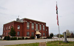
Lewis County is a county located in the U.S. state of Tennessee. As of the 2020 census, the population was 12,582. [2] Its county seat is Hohenwald. [3] The county is named for explorer Meriwether Lewis, who died and was buried at Grinder's Stand near Hohenwald in 1809.
Lewis County was formed in 1843 from parts of Perry, Hickman, Lawrence, Maury and Wayne counties. [1] It was named for explorer Meriwether Lewis of the Lewis and Clark Expedition. [4] Lewis's grave is located at the geographic center of the county. The bill for its creation was proposed by Powhatan Gordon in the Tennessee State Senate. [5]
On October 7, 2009, a ceremony was held at the cemetery to commemorate the bicentennial of Lewis's death. A bust of Lewis was presented to the National Park Service, which manages the site. [6]
Lewis County was the site of the Cane Creek Massacre.
According to the U.S. Census Bureau, the county has a total area of 282 square miles (730 km2), of which 282 square miles (730 km2) is land and 0.4 square miles (1.0 km2) (0.1%) is water. [7]
Census | Pop. | Note | %± |
---|---|---|---|
1850 | 4,438 | — | |
1860 | 2,241 | −49.5% | |
1870 | 1,986 | −11.4% | |
1880 | 2,181 | 9.8% | |
1890 | 2,555 | 17.1% | |
1900 | 4,455 | 74.4% | |
1910 | 6,033 | 35.4% | |
1920 | 5,707 | −5.4% | |
1930 | 5,258 | −7.9% | |
1940 | 5,849 | 11.2% | |
1950 | 6,078 | 3.9% | |
1960 | 6,269 | 3.1% | |
1970 | 6,761 | 7.8% | |
1980 | 9,700 | 43.5% | |
1990 | 9,247 | −4.7% | |
2000 | 11,367 | 22.9% | |
2010 | 12,161 | 7.0% | |
2020 | 12,582 | 3.5% | |
U.S. Decennial Census [8] 1790-1960 [9] 1900-1990 [10] 1990-2000 [11] 2010-2014 [12] |
Race | Number | Percentage |
---|---|---|
White (non-Hispanic) | 11,510 | 91.48% |
Black or African American (non-Hispanic) | 184 | 1.46% |
Native American | 31 | 0.25% |
Asian | 55 | 0.44% |
Pacific Islander | 5 | 0.04% |
Other/Mixed | 471 | 3.74% |
Hispanic or Latino | 326 | 2.59% |
As of the 2020 United States census, there were 12,582 people, 4,715 households, and 3,175 families residing in the county.
As of the census [15] of 2000, there were 11,367 people, 4,381 households, and 3,215 families residing in the county. The population density was 40 people per square mile (15 people/km2). There were 4,821 housing units at an average density of 17 units per square mile (6.6/km2). The racial makeup of the county was 97.07% White, 1.45% Black or African American, 0.20% Native American, 0.18% Asian, 0.29% from other races, and 0.80% from two or more races. 1.20% of the population were Hispanic or Latino of any race.
There were 4,381 households, out of which 33.20% had children under the age of 18 living with them, 58.90% were married couples living together, 10.70% had a female householder with no husband present, and 26.60% were non-families. 23.50% of all households were made up of individuals, and 10.60% had someone living alone who was 65 years of age or older. The average household size was 2.54 and the average family size was 2.98.
In the county, the population was spread out, with 25.80% under the age of 18, 8.30% from 18 to 24, 27.40% from 25 to 44, 24.80% from 45 to 64, and 13.60% who were 65 years of age or older. The median age was 37 years. For every 100 females there were 96.90 males. For every 100 females age 18 and over, there were 91.80 males.
The median income for a household in the county was $30,444, and the median income for a family was $35,972. Males had a median income of $27,060 versus $19,847 for females. The per capita income for the county was $14,664. About 10.30% of families and 13.40% of the population were below the poverty line, including 16.60% of those under age 18 and 12.20% of those age 65 or over.
Year | Republican | Democratic | Third party(ies) | |||
---|---|---|---|---|---|---|
No. | % | No. | % | No. | % | |
2024 | 4,852 | 82.38% | 991 | 16.83% | 47 | 0.80% |
2020 | 4,474 | 79.76% | 1,072 | 19.11% | 63 | 1.12% |
2016 | 3,585 | 77.56% | 890 | 19.26% | 147 | 3.18% |
2012 | 3,117 | 66.40% | 1,447 | 30.83% | 130 | 2.77% |
2008 | 2,951 | 61.05% | 1,804 | 37.32% | 79 | 1.63% |
2004 | 2,819 | 55.78% | 2,192 | 43.37% | 43 | 0.85% |
2000 | 2,037 | 46.09% | 2,281 | 51.61% | 102 | 2.31% |
1996 | 1,298 | 36.08% | 1,971 | 54.78% | 329 | 9.14% |
1992 | 1,218 | 29.34% | 2,491 | 60.00% | 443 | 10.67% |
1988 | 1,324 | 47.95% | 1,419 | 51.39% | 18 | 0.65% |
1984 | 1,733 | 52.42% | 1,556 | 47.07% | 17 | 0.51% |
1980 | 1,076 | 32.52% | 2,190 | 66.18% | 43 | 1.30% |
1976 | 617 | 20.32% | 2,391 | 78.75% | 28 | 0.92% |
1972 | 1,056 | 46.98% | 1,138 | 50.62% | 54 | 2.40% |
1968 | 455 | 17.91% | 1,088 | 42.83% | 997 | 39.25% |
1964 | 388 | 15.84% | 2,061 | 84.16% | 0 | 0.00% |
1960 | 580 | 25.09% | 1,723 | 74.52% | 9 | 0.39% |
1956 | 522 | 28.16% | 1,321 | 71.25% | 11 | 0.59% |
1952 | 540 | 29.05% | 1,308 | 70.36% | 11 | 0.59% |
1948 | 381 | 23.29% | 1,148 | 70.17% | 107 | 6.54% |
1944 | 252 | 20.88% | 955 | 79.12% | 0 | 0.00% |
1940 | 368 | 21.45% | 1,343 | 78.26% | 5 | 0.29% |
1936 | 331 | 23.66% | 1,068 | 76.34% | 0 | 0.00% |
1932 | 137 | 14.64% | 799 | 85.36% | 0 | 0.00% |
1928 | 269 | 39.39% | 414 | 60.61% | 0 | 0.00% |
1924 | 191 | 36.31% | 310 | 58.94% | 25 | 4.75% |
1920 | 446 | 52.29% | 403 | 47.25% | 4 | 0.47% |
1916 | 414 | 51.30% | 387 | 47.96% | 6 | 0.74% |
1912 | 126 | 19.50% | 370 | 57.28% | 150 | 23.22% |
1908 | 354 | 43.12% | 465 | 56.64% | 2 | 0.24% |
1904 | 220 | 33.54% | 415 | 63.26% | 21 | 3.20% |
1900 | 202 | 33.44% | 400 | 66.23% | 2 | 0.33% |
1896 | 204 | 38.27% | 329 | 61.73% | 0 | 0.00% |
1892 | 95 | 26.24% | 231 | 63.81% | 36 | 9.94% |
1888 | 132 | 33.93% | 254 | 65.30% | 3 | 0.77% |
1884 | 64 | 23.36% | 209 | 76.28% | 1 | 0.36% |
1880 | 37 | 15.55% | 200 | 84.03% | 1 | 0.42% |
1876 | 12 | 5.50% | 206 | 94.50% | 0 | 0.00% |
1872 | 34 | 20.36% | 133 | 79.64% | 0 | 0.00% |
1868 | 33 | 100.00% | 0 | 0.00% | 0 | 0.00% |
1860 | 8 | 2.64% | 0 | 0.00% | 295 | 97.36% |
1856 | 0 | 0.00% | 242 | 90.64% | 25 | 9.36% |
1852 | 43 | 18.78% | 186 | 81.22% | 0 | 0.00% |
Historically, like all of secessionist Middle Tennessee, Lewis County was overwhelmingly Democratic. Although it did vote for Charles Evans Hughes in 1916 and Warren G. Harding in 1920, Lewis County would be firmly Democratic for the next six decades, being one of only two Tennessee counties to remain loyal to both Hubert Humphrey in 1968 and George McGovern in 1972. Ronald Reagan broke this Democratic sequence with a 177-vote majority over Walter Mondale in his 1984 landslide, but Lewis County would subsequently remain Democratic up to 2000. Since then, however, like much of the rural white South, it has become overwhelmingly Republican due to opposition to the Democratic Party's liberal views on social issues. [17]
The county is served by Lewis County High School.
Marshall County is a county of the state of Alabama, United States. As of the 2020 census the population was 97,612. Its county seat is Guntersville. A second courthouse is in Albertville. Its name is in honor of John Marshall, famous Chief Justice of the United States. Marshall County is a dry county, with the exception of the five cities of Albertville, Arab, Grant, Guntersville, and Boaz. Marshall County comprises the Albertville, AL Micropolitan Statistical Area, which is also included in the Huntsville-Decatur-Albertville, AL Combined Statistical Area.
Wilson County is a county in the U.S. state of Tennessee. It is in Middle Tennessee. As of the 2020 census, the population was 147,737. Its county seat is Lebanon. The largest city is Mt. Juliet. Wilson County is part of the Nashville-Davidson–Murfreesboro–Franklin, TN Metropolitan Statistical Area.
Unicoi County is a county located in the U.S. state of Tennessee. As of the 2020 census, the population was 17,928. Its county seat is Erwin. Unicoi is a Cherokee word meaning "white," "hazy," "fog-like," or "fog draped," and refers to the mist often seen in the foothills and mountains of this far northeast county. Unicoi County is part of the Johnson City Metropolitan Statistical Area, which is a component of the Johnson City–Kingsport–Bristol, TN-VA Combined Statistical Area, commonly known as the "Tri-Cities" region.
Pickett County is a county located in the U.S. state of Tennessee. As of the 2020 census, the population was 5,001, making it the least populous county in Tennessee. Its county seat is Byrdstown. The city of Byrdstown and the Kentucky town of Albany, 11 miles (18 km) to the northeast, are positioned between two Army Corps of Engineers lakes: Dale Hollow Lake, mainly in Tennessee, and Lake Cumberland, in Kentucky. The area is known as "Twin Lakes" and Byrdstown is noted as "The Gateway To Dale Hollow Lake". Every year thousands of people vacation at the many resorts situated along the lakes.
Maury County is a county located in the U.S. state of Tennessee, in the Middle Tennessee region. As of the 2020 census, the population was 100,974. Its county seat is Columbia. Maury County is part of the Nashville-Davidson–Murfreesboro–Franklin, TN metropolitan statistical area.
Marshall County is a county located in the U.S. state of Tennessee. As of the 2020 census, the population was 34,318. Its county seat is Lewisburg. Marshall County comprises the Lewisburg Micropolitan Statistical Area, which is also included in the Nashville-Davidson–Murfreesboro–Franklin, TN Metropolitan Statistical Area. It is in Middle Tennessee, one of the three Grand Divisions of the state.
Lawrence County is a county located in the U.S. state of Tennessee. As of the 2020 census, the population was 44,159. Its county seat and largest city is Lawrenceburg. Lawrence County comprises the Lawrenceburg, TN Micropolitan Statistical Area, which is also included in the Nashville-Davidson-Murfreesboro, TN Combined Statistical Area.
Jackson County is a county located in the U.S. state of Tennessee. The population was 11,617 at the 2020 census. Its county seat is Gainesboro. Jackson is part of the Cookeville Micropolitan Statistical Area.
Hickman County is a county located in the U.S. state of Tennessee. As of the 2020 Census, the population was 24,925. Its county seat is Centerville. As of 2023, Hickman County is part of the Nashville–Davidson–Murfreesboro–Franklin, TN Metropolitan Statistical Area, although it was once removed in 2018.
Giles County is a county located in the U.S. state of Tennessee. As of the 2020 census, its population was 30,346. Its county seat is Pulaski.
Decatur County is a county located in the U.S. state of Tennessee. As of the 2020 census, the population was 11,435. Its county seat is Decaturville.
Cumberland County is a county located in the U.S. state of Tennessee. As of the 2020 census, the population was 61,145. Its county seat is Crossville. Cumberland County comprises the Crossville, TN micropolitan statistical area.
Crockett County is a county located in the U.S. state of Tennessee. As of the 2020 census, the population was 13,911. Its county seat is Alamo. Crockett County is included in the Jackson, TN Metropolitan Statistical Area.
Bledsoe County is a county located in the U.S. state of Tennessee. As of the 2020 census, the population was 14,913. Its county seat is Pikeville.
Teton County is a county in the U.S. state of Montana. As of the 2020 census, the population was 6,226. Its county seat is Choteau. The county was founded in 1893.
Mason County is a county located in the U.S. state of Kentucky. As of the 2020 census, the population was 17,120. Its county seat is Maysville. The county was created from Bourbon County, Virginia in 1788 and named for George Mason, a Virginia delegate to the U.S. Constitutional Convention known as the "Father of the Bill of Rights". Mason County comprises the Maysville, KY Micropolitan Statistical Area, which is included in the Cincinnati-Wilmington-Maysville, OH-KY-IN Combined Statistical Area.
Maury City is a town in Crockett County, Tennessee. The population was 674 at the 2010 census. Locals pronounce the town's name as "Murray City."
Hohenwald is a city in and the county seat of Lewis County, Tennessee. The population was 3,757 at the 2010 census. The name "Hohenwald" derives from German meaning “High Forest".
Lewisburg is a city in and the county seat of Marshall County, Tennessee, United States. The population was 12,288 in 2020. Lewisburg is located in Middle Tennessee, fifty miles south of Nashville and fifty-two miles north of Huntsville, Alabama. Residents have access to the larger cities via nearby I-65.
Waynesboro is a city in and the county seat of Wayne County, Tennessee, United States. The population was 2,449 at the 2010 census, up from 2,228 in 2000.
The bill creating the County of Lewis was introduced by the Hon. Powhatan Gordon, of Maury County, the main purpose of the bill being to perpetuate the name of Lewis.