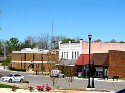
Coffee County, Tennessee

Last updated

Coffee County
Coffecocourthouse.JPG
Coffee County Courthouse in Manchester
Flag of Coffee County, Tennessee.png
Coffeecotn.jpg
Map of Tennessee highlighting Coffee County.svg
Location within the U.S. state of Tennessee
Tennessee in United States.svg
Tennessee's location within the U.S.
Coordinates: 35°29′N86°04′W / 35.49°N 86.07°W / 35.49; -86.07
CountryFlag of the United States.svg United States
StateFlag of Tennessee.svg  Tennessee
FoundedJanuary 8, 1836
Named for John Coffee
Seat Manchester
Largest city Tullahoma
Area
  Total
435 sq mi (1,130 km2)
  Land429 sq mi (1,110 km2)
  Water5.6 sq mi (15 km2)  1.3%
Population
 (2020)
  Total
57,889 Increase2.svg
  Density123/sq mi (47/km2)
Time zone UTC−6 (Central)
  Summer (DST) UTC−5 (CDT)
Congressional district 4th
Website www.coffeecountytn.gov

Coffee County is a county located in the central part of the state of Tennessee, in the United States. As of the 2020 census, the county's population was 57,889. [1] Its county seat is Manchester. [2] Coffee County is part of the Tullahoma-Manchester, TN Micropolitan Statistical Area. It is also part of Middle Tennessee, one of the three Grand Divisions of the state.

Contents

History

Coffee County was formed in 1836 from parts of Bedford, Warren, and Franklin counties. [3] It was named for John Coffee, a prominent planter, land speculator, and militia officer. [4] [5]

In the period after the Reconstruction era ended (1877) and into the early 20th century, whites in Coffee County committed eight lynchings of blacks. This was the fifth-highest total of any county in the state, but three other counties also had eight lynchings each. [6]

Century Farms

Coffee County has twelve Century Farms, the classification for farms that have been operating for more than 100 years. The oldest Century Farm is Shamrock Acres, founded in 1818. Other Century Farms include: [3]

Geography

State Route 127 near Hillsboro Highway127-near-Hillsboro-tn1.jpg
State Route 127 near Hillsboro
Machine Falls at Short Springs State Natural Area Machine falls in Coffee County, TN.jpg
Machine Falls at Short Springs State Natural Area

According to the U.S. Census Bureau, the county has a total area of 435 square miles (1,130 km2), of which 429 square miles (1,110 km2) is land and 5.6 square miles (15 km2) (1.3%) is water. [7]

Adjacent counties

Major highways

State protected areas

Demographics

Historical population
CensusPop.Note
1840 8,184
1850 8,3512.0%
1860 9,68916.0%
1870 10,2375.7%
1880 12,89426.0%
1890 13,8277.2%
1900 15,57412.6%
1910 15,6250.3%
1920 17,34411.0%
1930 16,801−3.1%
1940 18,95912.8%
1950 23,04921.6%
1960 28,60324.1%
1970 32,57213.9%
1980 38,31117.6%
1990 40,3395.3%
2000 48,01419.0%
2010 52,79610.0%
2020 57,8899.6%
U.S. Decennial Census [8]
1790-1960 [9] 1900-1990 [10]
1990-2000 [11] 2010-2014 [12]
Age pyramid Coffee County USA Coffee County, Tennessee.csv age pyramid.svg
Age pyramid Coffee County

2020 census

Coffee County racial composition [14]
RaceNumberPercentage
White (non-Hispanic)48,98384.62%
Black or African American (non-Hispanic)2,0973.62%
Native American 1450.25%
Asian 6111.06%
Pacific Islander 370.06%
Other/Mixed 2,7574.76%
Hispanic or Latino 3,2595.63%

As of the 2020 United States census, there were 57,889 people, 21,646 households, and 14,777 families residing in the county.

2000 census

As of the census [15] of 2000, there were 48,014 people, 18,885 households, and 13,597 families residing in the county. The population density was 112 people per square mile (43 people/km2). There were 20,746 housing units at an average density of 48 units per square mile (19/km2). The racial makeup of the county was 93.43% White, 3.59% Black or African American, 0.30% Native American, 0.74% Asian, 0.03% Pacific Islander, 0.91% from other races, and 1.00% from two or more races. 2.19% of the population were Hispanic or Latino of any race.

There were 18,885 households, out of which 32.40% had children under the age of 18 living with them, 56.90% were married couples living together, 11.10% had a female householder with no husband present, and 28.00% were non-families. 24.30% of all households were made up of individuals, and 10.30% had someone living alone who was 65 years of age or older. The average household size was 2.50 and the average family size was 2.96.

In the county, the population was spread out, with 25.10% under the age of 18, 8.30% from 18 to 24, 28.40% from 25 to 44, 23.60% from 45 to 64, and 14.60% who were 65 years of age or older. The median age was 38 years. For every 100 females, there were 95.10 males. For every 100 females age 18 and over, there were 92.30 males.

The median income for a household in the county was $34,898, and the median income for a family was $40,228. Males had a median income of $32,732 versus $21,014 for females. The per capita income for the county was $18,137. About 10.90% of families and 14.30% of the population were below the poverty line, including 17.80% of those under age 18 and 15.20% of those age 65 or over.

Events

The Bonnaroo Music Festival has been held annually in the county since 2002. [16]

Notable people

Points of interest

George Dickel Distillery GeorgeDickelDistillery.jpg
George Dickel Distillery

Communities

Cities

Manchester Manchester-Tennessee-Fort-St-tn1.jpg
Manchester

Census-designated places

Unincorporated communities

Politics

Coffee County is a Republican stronghold. The last Democrat to carry this county was Bill Clinton in 1996.

United States presidential election results for Coffee County, Tennessee [18]
Year Republican Democratic Third party(ies)
No.%No.%No.%
2024 19,17476.91%5,44021.82%3181.28%
2020 17,88373.65%5,70523.49%6942.86%
2016 14,41772.19%4,74323.75%8114.06%
2012 13,02367.62%5,87030.48%3661.90%
2008 13,25063.73%7,13234.30%4081.96%
2004 11,79358.48%8,24340.87%1310.65%
2000 8,78849.40%8,74149.14%2591.46%
1996 7,03843.18%7,95148.78%1,3128.05%
1992 6,04735.48%8,53450.07%2,46314.45%
1988 7,83757.56%5,68641.76%920.68%
1984 7,69557.14%5,69142.26%820.61%
1980 5,45440.72%7,61256.84%3272.44%
1976 3,84832.05%8,01766.78%1401.17%
1972 6,41666.18%2,97330.67%3063.16%
1968 3,33729.87%3,04027.21%4,79442.91%
1964 3,01230.58%6,83769.42%00.00%
1960 3,05839.79%4,55559.26%730.95%
1956 2,38932.42%4,93066.90%500.68%
1952 2,11037.25%3,53762.44%180.32%
1948 59916.63%2,04156.68%96126.69%
1944 56817.35%2,70382.56%30.09%
1940 42415.63%2,27783.96%110.41%
1936 40815.88%2,14883.58%140.54%
1932 43017.92%1,95081.25%200.83%
1928 1,12648.72%1,17550.84%100.43%
1924 48821.80%1,69175.52%602.68%
1920 82228.69%2,04371.31%00.00%
1916 48920.84%1,83778.30%200.85%
1912 52122.49%1,70573.59%913.93%

See also

Related Research Articles

<span class="mw-page-title-main">Henry County, Alabama</span> County in Alabama, United States

Henry County is a county in the southeastern part of the U.S. state of Alabama. As of the 2020 census, its population was 17,146. Its county seat is Abbeville. The county was named for Patrick Henry (1736–1799), famous orator and Governor of Virginia.

<span class="mw-page-title-main">Wilson County, Tennessee</span> County in Tennessee, United States

Wilson County is a county in the U.S. state of Tennessee. It is in Middle Tennessee. As of the 2020 census, the population was 147,737. Its county seat is Lebanon. The largest city is Mt. Juliet. Wilson County is part of the Nashville-Davidson–Murfreesboro–Franklin, TN Metropolitan Statistical Area.

<span class="mw-page-title-main">Weakley County, Tennessee</span> County in Tennessee, United States

Weakley County is a county located in the northwest of the U.S. state of Tennessee. As of the 2020 census, the population was 32,902. Its county seat is Dresden. Its largest city is Martin, the home of the University of Tennessee at Martin. The county was established by the Tennessee General Assembly on October 21, 1823, and is named for U.S. Congressman Robert Weakley (1764–1845). Weakley County comprises the Martin, TN Micropolitan Statistical Area.

<span class="mw-page-title-main">Morgan County, Tennessee</span> County in Tennessee, United States

Morgan County is a county located in the U.S. state of Tennessee. As of the 2020 census, the population was 21,035. Its county seat is Wartburg. Morgan County is part of the Knoxville, TN Combined Statistical Area.

<span class="mw-page-title-main">Moore County, Tennessee</span> County in Tennessee, United States

Moore County is a county located in the south central part of the U.S. state of Tennessee. As of the 2020 census, the population was 6,461, making it the third-least populous county in Tennessee. It forms a consolidated city-county government with its county seat of Lynchburg. At 130 square miles (340 km2), it is the second-smallest county in Tennessee, behind only Trousdale. The county was created in 1871, during the Reconstruction era. Moore County is part of the Tullahoma-Manchester, TN Micropolitan Statistical Area.

<span class="mw-page-title-main">Lincoln County, Tennessee</span> County in Tennessee, United States

Lincoln County is a county located in the south central part of the U.S. state of Tennessee. As of the 2020 census, the population was 35,319. Its county seat and largest city is Fayetteville. The county is named for Major General Benjamin Lincoln, an officer in the American Revolutionary War.

<span class="mw-page-title-main">Lauderdale County, Tennessee</span> County in Tennessee, United States

Lauderdale County is a county located on the western edge of the U.S. state of Tennessee, with its border the Mississippi River. As of the 2020 census, the population was 25,143. Its county seat is Ripley. Since the antebellum years, it has been developed for cotton as a major commodity crop.

<span class="mw-page-title-main">Lake County, Tennessee</span> County in Tennessee, United States

Lake County is a county located in the northwest corner of the U.S. state of Tennessee. As of the 2020 census, the population was 7,005, making it the fifth-least populous county in Tennessee. Its county seat is Tiptonville. It shares a border with Kentucky to the north and is separated from Missouri to the west by the Mississippi River.

<span class="mw-page-title-main">Haywood County, Tennessee</span> County in Tennessee, United States

Haywood County is a county located in the U.S. state of Tennessee, in the region known as West Tennessee. As of the 2020 census, the population was 17,864. Its county seat and largest city is Brownsville. It is one of only two remaining counties in Tennessee, along with Shelby County, with a majority African-American population.

<span class="mw-page-title-main">Franklin County, Tennessee</span> County in Tennessee, United States

Franklin County is a county in the U.S. state of Tennessee. It is located on the eastern boundary of Middle Tennessee in the southern part of the state. As of the 2020 census, the population was 42,774. Its county seat is Winchester. Franklin County was formerly part of the Tullahoma-Manchester, TN Micropolitan Statistical Area, it was removed in 2023 and is part of the Winchester Micropolitan Statistical Area.

<span class="mw-page-title-main">Benton County, Tennessee</span> County in Tennessee, United States

Benton County is a county located in the U.S. state of Tennessee. As of the 2020 census, the population was 15,864. Its county seat is Camden. The county was created in December 1835 and organized in 1836.

<span class="mw-page-title-main">Bedford County, Tennessee</span> County in Tennessee, United States

Bedford County is a county located in the U.S. state of Tennessee. As of the 2020 census, the population was 50,237. Its county seat is Shelbyville. Bedford County comprises the Shelbyville, TN Micropolitan Statistical Area, which is also included in the Nashville-Davidson-Murfreesboro, TN Combined Statistical Area.

<span class="mw-page-title-main">Chesterfield County, South Carolina</span> County in South Carolina, United States

Chesterfield County is a county located in the U.S. state of South Carolina. As of the 2020 census, its population was 43,273. Its county seat is Chesterfield. The largest community in the county is Cheraw. It is located north of the Midlands, in the Pee Dee region, on its border with North Carolina.

<span class="mw-page-title-main">Graves County, Kentucky</span> County in Kentucky, United States

Graves County is a county located on the southwest border of the U.S. Commonwealth of Kentucky. As of the 2020 census, the population was 36,649. Its county seat is Mayfield. The county was formed in 1824 and was named for Major Benjamin Franklin Graves, a politician and fallen soldier in the War of 1812.

<span class="mw-page-title-main">Fulton County, Kentucky</span> County in Kentucky, United States

Fulton County is the westernmost county in the U.S. state of Kentucky, with the Mississippi River forming its western boundary. As of the 2020 census, the population was 6,515. Its county seat is Hickman and its largest city is Fulton. The county was formed in 1845 from Hickman County, Kentucky and named for Robert Fulton, the inventor of the steamboat.

<span class="mw-page-title-main">Versailles, Kentucky</span> City in Kentucky, United States

Versailles is a home rule-class city in Woodford County, Kentucky, United States. It lies 13 miles by road west of Lexington and is part of the Lexington-Fayette Metropolitan Statistical Area. Versailles has a population of 10,534 according to 2024 census estimates. It is the county seat of Woodford County. The city's name is pronounced vər-SAYLZ, an anglicization different from the French pronunciation of the royal city of the same name near Paris.

<span class="mw-page-title-main">Manchester, Tennessee</span> City in Tennessee, United States

Manchester is a city and the county seat of Coffee County, Tennessee, United States. The population was 12,213 at the 2020 census.

<span class="mw-page-title-main">Tullahoma, Tennessee</span> City in Tennessee, United States

Tullahoma is a city in Coffee and Franklin counties in southern Middle Tennessee, United States. The population was 20,339 at the 2020 census. In 2019, the population was estimated to be 19,555. It is the principal city of the Tullahoma micropolitan area, which consists of Coffee and Moore counties and is the second largest micropolitan area in Tennessee. The city is also partially in the Winchester Micropolitan area.

<span class="mw-page-title-main">Trimble, Tennessee</span> Town in Tennessee, United States

Trimble is a town in Dyer and Obion counties in the U.S. state of Tennessee. The population was 637 at the 2010 census.

<span class="mw-page-title-main">Lynchburg, Tennessee</span> Consolidated city-county in Tennessee, United States

Lynchburg is a city in the south-central region of the U.S. state of Tennessee. It is governed by a consolidated city-county government unit whose boundaries coincide with those of Moore County. Lynchburg is best known as the location of Jack Daniel's distillery, whose famous Tennessee whiskey is marketed worldwide as the product of a city with only one traffic light. Despite the operational distillery, which is a major tourist attraction, Lynchburg's home county of Moore is a dry county. Sampling whiskey is permitted in the distillery, however. The population was 6,461 at the 2020 census.

References

  1. "Census - Geography Profile: Coffee County, Tennessee". United States Census Bureau . Retrieved December 31, 2022.
  2. "Find a County". National Association of Counties. Archived from the original on May 31, 2011. Retrieved June 7, 2011.
  3. 1 2 "Coffee County Century Farms". MTSU Center for Historic Preservation. Archived from the original on June 25, 2012. Retrieved December 22, 2012.
  4. Carroll Van West, "Coffee County," Tennessee Encyclopedia of History and Culture. Retrieved: June 25, 2013.
  5. Gannett, Henry (1905). The Origin of Certain Place Names in the United States. Govt. Print. Off. pp.  86.
  6. Lynching in America, Third Edition: Supplement by County Archived October 23, 2017, at the Wayback Machine , p. 9, Equal Justice Initiative, Mobile, AL, 2017
  7. "2010 Census Gazetteer Files". United States Census Bureau. August 22, 2012. Retrieved April 2, 2015.
  8. "U.S. Decennial Census". United States Census Bureau. Retrieved April 2, 2015.
  9. "Historical Census Browser". University of Virginia Library. Archived from the original on August 11, 2012. Retrieved April 2, 2015.
  10. Forstall, Richard L., ed. (March 27, 1995). "Population of Counties by Decennial Census: 1900 to 1990". United States Census Bureau. Retrieved April 2, 2015.
  11. "Census 2000 PHC-T-4. Ranking Tables for Counties: 1990 and 2000" (PDF). United States Census Bureau. April 2, 2001. Archived (PDF) from the original on October 9, 2022. Retrieved April 2, 2015.
  12. "State & County QuickFacts". United States Census Bureau. Archived from the original on June 26, 2001. Retrieved November 29, 2013.
  13. Based on 2000 census data
  14. "Explore Census Data". data.census.gov. Retrieved December 24, 2021.
  15. "U.S. Census website". United States Census Bureau . Retrieved May 14, 2011.
  16. "About Us". Bonnaroo Music Festival. Archived from the original on January 17, 2013.
  17. Short Springs State Natural Area, Tennessee Department of Environment and Conservation website. Retrieved: June 25, 2013.
  18. Leip, David. "Dave Leip's Atlas of U.S. Presidential Elections". uselectionatlas.org. Retrieved March 10, 2018.

35°29′N86°04′W / 35.49°N 86.07°W / 35.49; -86.07