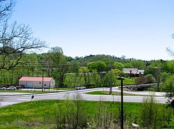
Beechgrove, Tennessee | |
---|---|
Coordinates: 35°37′37″N86°14′25″W / 35.62694°N 86.24028°W | |
Country | United States |
State | Tennessee |
County | Coffee |
Elevation | 267 m (876 ft) |
Time zone | UTC-6 (Central (CST)) |
• Summer (DST) | UTC-5 (CDT) |
ZIP code(s) | 37018 |
Area code | 931 |
GNIS feature ID | 1269328 [1] |
Beechgrove, also known as Beech Grove, is an unincorporated community in Coffee County, Tennessee, United States. Beechgrove is located in northwestern Coffee County at the junction of Interstate 24, U.S. Route 41, and State Route 64. [2] Beechgrove has a post office with ZIP code 37018. [3] [4]
Beechgrove, Tennessee, was named "Beech Grove," until zip codes were assigned to U.S. Post Offices. At that time the post office named "Beech Grove" in another county was given its zip code before the Coffee County location received its code; thus to avoid confusion among postal users, and the Postal system itself, Beech Grove (Coffee County), Tennessee was changed, officially, to "Beechgrove." Locals living there protested to postal authorities, but to no avail. The name "stuck," so to speak.
The community was named from the presence of beech trees near the town site. [5] A post office has been in operation at Beechgrove since 1836. [6] Between June 24–26, 1863, the Battle of Hoover's Gap was fought around Beechgrove. The Beechgrove Confederate Cemetery now occupies a portion of the battlefield, on top of a hill overlooking present-day I-24. It contains 56 graves; 52 are of unknown soldiers. [7]
Murray County is a county located in the northwestern part of the U.S. state of Georgia. As of the 2020 census, the population was 39,973. The county seat is Chatsworth.
Elizaville is a census-designated place and unincorporated community in Fleming County, Kentucky, United States. Its population was 181 as of the 2010 census. Elizaville is located at the junction of Kentucky Route 32 and Kentucky Route 170, 5 miles (8.0 km) west of Flemingsburg. Elizaville has a post office with ZIP code 41037.
Delano is an unincorporated community in Polk County, Tennessee, United States. It is located near the junction of U.S. Route 411, Tennessee State Route 30 and Tennessee State Route 163 4.3 miles (6.9 km) south-southwest of Etowah. Delano has a post office with ZIP code 37325, which opened on August 14, 1909.
Bon Aqua is an unincorporated community in Hickman County, Tennessee, United States. Bon Aqua is located in northern Hickman County, 9.2 miles (14.8 km) south-southeast of Dickson. It also covers parts of Southeast Dickson county, and parts of Western Williamson county. Bon Aqua has a post office with ZIP code 37025, which opened on March 5, 1842.
Beech Bluff is an unincorporated community on the east-central edge of Madison County, Tennessee, United States. The area ZIP code is 38313.
Evensville is an unincorporated community in Rhea County, Tennessee, United States. In 2020 the population was 2,624. Evensville is located along U.S. Route 27 5.8 miles (9.3 km) northeast of Dayton. Evensville has a post office with ZIP code 37332. Rhea County High School is located in Evensville.
Smartt is an unincorporated community in Warren County, Tennessee, United States. Smartt is located along Tennessee State Route 55 and the Caney Fork and Western Railroad 4.5 miles (7.2 km) southwest of McMinnville. Smartt has a post office with ZIP code 37378.
Lancing is an unincorporated community in Morgan County, Tennessee, United States. Lancing is located along Tennessee State Route 62 and the Norfolk Southern Railway 3.35 miles (5.39 km) west-northwest of Wartburg, and northeast of the Catoosa Wildlife Management Area. Lancing has a post office with ZIP code 37770.
Moss is an unincorporated community in Clay County, Tennessee, United States.
Holladay is an unincorporated community and census-designated place in Benton and Decatur counties in the U.S. state of Tennessee. Holladay is located along Tennessee State Route 192 13.3 miles (21.4 km) south-southwest of Camden. Another portion of the community is located at the intersection of I-40 and US 641/SR 69. Holladay has a post office with ZIP code 38341, which opened on February 23, 1887.
Only is an unincorporated community in Hickman County, Tennessee, United States. Only is located on Tennessee State Route 229 near Tennessee State Route 50 and Interstate 40, 13.9 miles (22.4 km) west-northwest of Centerville. Only has a post office, with ZIP code 37140.
Grandview is an unincorporated community in Rhea County, Tennessee, United States. Grandview is located along Tennessee State Route 68 at the eastern edge of the Cumberland Plateau, 3.7 miles (6.0 km) north-northeast of Spring City. Grandview's ZIP code is 37337.
Pruden is an unincorporated community located partly in Bell County, Kentucky and partly in Claiborne County, Tennessee, in the southeastern United States. It is located along Tennessee State Route 90 and Kentucky Route 74, which intersect at the state line, in the upper Clearfork Valley.
Nunnelly is an unincorporated community in Hickman County, Tennessee, United States. Nunnelly is located at the junction of state routes 48 and 230, 5.6 miles (9.0 km) north of Centerville. Nunnelly has a post office, with ZIP code 37137.
Kelso is an unincorporated community in Lincoln County, Tennessee, United States. Kelso is located along U.S. Route 64 6 miles (9.7 km) east-southeast of Fayetteville. Kelso has a post office with ZIP code 37348. The community is home to the original Benjamin Prichard's distillery.
Mulberry is an unincorporated community in Lincoln County, Tennessee, United States. Mulberry is located along Tennessee State Route 50, 7.4 miles (11.9 km) northeast of Fayetteville. Mulberry has a post office with ZIP code 37359, which opened on January 7, 1828. The community was named for the red mulberry plants found in the area.
Flintville is an unincorporated community in Lincoln County, Tennessee, United States. As of the 2010 census, its population was 627. Flintville is located approximately 10.5 miles (16.9 km) southeast of Fayetteville along Tennessee State Route 275 highway.
Pelham is an unincorporated community and census-designated place (CDP) in Grundy County, Tennessee, United States. As of the 2010 census, its population was 403. Pelham is located at the junction of U.S. Route 41, State Route 2, and State Route 50 near the base of the Cumberland Plateau, 5.35 miles (8.61 km) north-northwest of Monteagle. Pelham has a post office with ZIP code 37366, which opened on April 4, 1832.
Summitville is an unincorporated community in Coffee County, Tennessee, United States. Summitville is located along the Caney Fork and Western Railroad near Tennessee State Route 55, 7.6 miles (12.2 km) northeast of Manchester. Summitville has a post office with ZIP code 37382, which opened on June 5, 1877. The Crouch-Ramsey Family Farm, which is listed on the National Register of Historic Places, is located near Summitville.
Beech Grove is an unincorporated community and census-designated place in McLean County, Kentucky, United States. Its population was 282 as of the 2020 census. Beech Grove has a post office with ZIP code 42322, which opened on April 29, 1878.