
Denver is the central city of a conurbation region in the U.S. state of Colorado. The conurbation includes one continuous region consisting of the six central counties of Adams, Arapahoe, Broomfield, Denver, Douglas, and Jefferson. The Denver region is part of the Front Range Urban Corridor and its metropolitan planning organization is the Denver Regional Council of Governments.
In the United States, a metropolitan statistical area (MSA) is a geographical region with a relatively high population density at its core and close economic ties throughout the region. Such regions are not legally incorporated as a city or town would be and are not legal administrative divisions like counties or separate entities such as states. As a result, sometimes the precise definition of a given metropolitan area will vary between sources. The statistical criteria for a standard metropolitan area were defined in 1949 and redefined as a metropolitan statistical area in 1983.

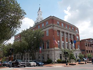
The Tri-Cities is the region comprising the cities of Kingsport, Johnson City, and Bristol and the surrounding smaller towns and communities in Northeast Tennessee and Southwest Virginia. All three cities are located in Northeast Tennessee, while Bristol has a twin city of the same name in Virginia.
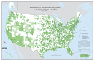
United States micropolitan statistical areas, as defined by the Office of Management and Budget (OMB), are labor market and statistical areas in the United States centered on an urban cluster with a population of at least 10,000 but fewer than 50,000 people. The micropolitan area designation was created in 2003. Like the better-known metropolitan statistical areas, a micropolitan area is a geographic entity used for statistical purposes based on counties and county equivalents. On July 21, 2023, the Office of Management and Budget released revised delineations of the various CBSAs in the United States, which recognized 542 micropolitan areas in the United States, four of which are in Puerto Rico.

The Kingsport–Bristol–Bristol metropolitan area is a metropolitan statistical area (MSA) in Northeast Tennessee and Southwest Virginia, United States, as defined by the Office of Management and Budget (OMB). It was formed in December 2003 by the merger of the Bristol, VA MSA and Kingsport–Bristol, TN–VA MSA.

The Clarksville Metropolitan Statistical Area is defined by the United States Census Bureau as an area consisting of four counties – two in Tennessee and two in Kentucky – anchored by the city of Clarksville, Tennessee. The 2021 estimate placed the population at 329,864. As of 2020, the Clarksville Metropolitan Statistical Area was the 159th largest MSA in the United States.

The Omaha metropolitan area, officially known as the Omaha, NE–IA, Metropolitan Statistical Area (MSA), is an urbanized, bi-state metro region in Nebraska and Iowa in the American Midwest, centered on the city of Omaha, Nebraska. The region consists of eight counties, and extends over a large area on both sides of the Missouri River. Covering 4,407 square miles (11,410 km2) and with a population of 967,604 (2020), the Omaha metropolitan area is the most populous in both Nebraska and Iowa, and is the 58th most populous MSA in the United States. The 2003 revision to metropolitan area definitions was accompanied by the creation of micropolitan areas and combined statistical areas. Fremont, in Dodge County, Nebraska, was designated a micropolitan area. The Omaha–Fremont Combined Statistical Area has a population of 1,058,125 . Approximately 1.5 million people reside within the Greater Omaha area, within a 50 mi (80 km) radius of Downtown Omaha.

The Memphis–Clarksdale-Forrest City Combined Statistical Area, TN–MS–AR (CSA) is the commercial and cultural hub of the Mid-South or Ark-Miss-Tenn. The census-defined combined statistical area covers eleven counties in three states, Tennessee, Mississippi, and Arkansas. As of 2020 census, the Memphis metropolitan area had a population of 1,389,905 The Forrest City, Arkansas Micropolitan area was added to the Memphis area in 2012 to form the Memphis–Forrest City Combined Statistical area. In 2023 the Clarksdale, Mississippi Micropolitan area was also added to form the new Memphis-Clarksdale-Forrest City Combined Statistical Area which as of 2023 had a population of roughly 1.4 million people according to census estimates.

The Lexington-Fayette metropolitan area is the 109th-largest metropolitan statistical area (MSA) in the United States. It was originally formed by the United States Census Bureau in 1950 and consisted solely of Fayette County until 1980 when surrounding counties saw increases in their population densities and the number of their residents employed within Lexington-Fayette, which led to them meeting Census criteria to be added to the MSA.

The Nashville metropolitan area is a metropolitan statistical area in north-central Tennessee. Its principal city is Nashville, the capital of and largest city in Tennessee. With a population of over 2 million, it is the most populous metropolitan area in Tennessee. It is also the largest metropolitan area in Tennessee in terms of land area.

The Knoxville metropolitan area, commonly known as Greater Knoxville, is a metropolitan statistical area (MSA) centered on Knoxville, Tennessee, the third largest city in Tennessee and the largest city in East Tennessee. It is the third largest metropolitan area in Tennessee. In 2020, the Knoxville metro area had a population of 879,773, and a population of 903,300 including Grainger County. The Knoxville–Morristown–Sevierville Combined Statistical Area (CSA) had a population of 1,156,861 according to the census bureau in 2020.

The Chattanooga, TN-GA metropolitan statistical area, as defined by the United States Office of Management and Budget, is an area consisting of six counties – three in southeast Tennessee and three in northwest Georgia – anchored by the city of Chattanooga. As of the 2020 census, the Chattanooga metropolitan area had a population of 562,647. This metropolitan area traverses two time zones.

The Cleveland, Tennessee Metropolitan Statistical Area, as defined by the United States Census Bureau, is an area consisting of two counties in southeast Tennessee – Bradley and Polk – anchored by the city of Cleveland. As of the 2020 United States census, the MSA had a population of 126,164. The MSA is also part of the Chattanooga Combined Statistical Area. The MSA was first designated in June 2003. Geographically, this metropolitan area is mostly coexistant with the Ocoee Region, a historical and cultural name that reflects the heritage of the area.

The Cookeville Micropolitan Statistical Area as defined by the United States Census Bureau, is an area consisting of four counties in central Tennessee, anchored by the city of Cookeville.
The Tullahoma–Manchester Micropolitan Statistical Area, as defined by the United States Census Bureau, is an area consisting of two counties in central Tennessee, anchored by the cities of Tullahoma and Manchester.

The Huntsville Metropolitan Statistical Area is a metropolitan statistical area on the northern border of Alabama. The metro area's principal city is Huntsville, and consists of two counties: Limestone and Madison. As of the 2020 United States census, the Huntsville Metropolitan Area's population was 491,723, making it the 2nd-largest metropolitan area in Alabama and the 113th-largest in the United States.
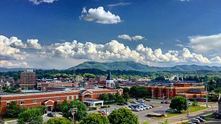
The Johnson City Metropolitan Statistical Area, as defined by the United States Census Bureau, is an area consisting of three counties in East Tennessee, anchored by the city of Johnson City. As of the 2020 census, the MSA had a population of 207,285.
The Hagerstown–Martinsburg metropolitan area, officially designated by the United States Office of Management and Budget (OMB) as Hagerstown–Martinsburg, Maryland–West Virginia Metropolitan Statistical Area (MSA), constitutes the primary cities of Hagerstown, Maryland; Martinsburg, West Virginia; and surrounding areas in three counties: Washington County, Maryland; Berkeley County, West Virginia; and Morgan County, West Virginia. The metro area lies mainly within the rich, fertile Cumberland and Shenandoah valleys, and is approximately a 60–90 minute drive from Washington, D.C.; Baltimore, Maryland; and Harrisburg, Pennsylvania; Hagerstown is approximately 75 miles (121 km) driving distance from all three cities. The population of the metropolitan area as of 2008 is 263,753.

The Birmingham metropolitan area, sometimes known as Greater Birmingham, is a metropolitan area in north central Alabama centered on Birmingham, Alabama, United States.


