Bedford County, Tennessee

Last updated

Bedford County
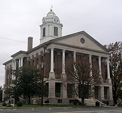
Bedford County Tennessee Courthouse.jpg
Bedford County Courthouse in Shelbyville
Bedford-co-tn.png
Map of Tennessee highlighting Bedford County.svg
Location within the U.S. state of Tennessee
Tennessee in United States.svg
Tennessee's location within the U.S.
Coordinates: 35°31′N86°28′W / 35.51°N 86.46°W / 35.51; -86.46
CountryFlag of the United States.svg United States
StateFlag of Tennessee.svg  Tennessee
FoundedDecember 7, 1807 [1]
Named for Thomas Bedford [2]
Seat Shelbyville
Largest cityShelbyville
Area
  Total
475 sq mi (1,230 km2)
  Land474 sq mi (1,230 km2)
  Water1.2 sq mi (3 km2)  0.2%
Population
 (2020)
  Total
50,237 Increase2.svg
  Density105.99/sq mi (40.92/km2)
Time zone UTC−6 (Central)
  Summer (DST) UTC−5 (CDT)
Congressional district 4th
Website www.bedfordcountytn.org

Bedford County is a county located in the U.S. state of Tennessee. As of the 2020 census, the population was 50,237. [3] Its county seat is Shelbyville. [4] Bedford County comprises the Shelbyville, TN Micropolitan Statistical Area, which is also included in the Nashville-Davidson-Murfreesboro, TN Combined Statistical Area.

Contents

History

The county was created in 1807 when the citizens of Rutherford County living south of the Duck River and the Stones River successfully petitioned the governor to split Rutherford County in two. The new county was named after American Revolutionary War officer and large landowner in the area, Thomas Bedford.

Once the state's largest and most populous county, Bedford County's size (in terms of area) has been steadily reduced since 1809 to form Coffee County, Moore County, Lincoln County, and Marshall County. [5]

The county was pro-Confederate during the Civil War, but Shelbyville was mostly loyal to the Union.

Texas pioneer William Whitaker Reed was born in Bedford County in 1816. [6]

Geography

According to the U.S. Census Bureau, the county has a total area of 475 square miles (1,230 km2), of which 474 square miles (1,230 km2) is land and 1.2 square miles (3.1 km2) (0.2%) is water. [7]

Adjacent counties

State protected areas

Demographics

Historical population
CensusPop.Note
1810 8,242
1820 16,01294.3%
1830 30,39689.8%
1840 20,546−32.4%
1850 21,5114.7%
1860 21,5840.3%
1870 24,33312.7%
1880 26,0257.0%
1890 24,739−4.9%
1900 23,845−3.6%
1910 22,667−4.9%
1920 21,737−4.1%
1930 21,077−3.0%
1940 23,1519.8%
1950 23,6272.1%
1960 23,150−2.0%
1970 25,0398.2%
1980 27,91611.5%
1990 30,4118.9%
2000 37,58623.6%
2010 45,05819.9%
2020 50,23711.5%
U.S. Decennial Census [8]
1790-1960 [9] 1900-1990 [10]
1990-2000 [11] 2010-2014 [3]
Age pyramid, Bedford County USA Bedford County, Tennessee.csv age pyramid.svg
Age pyramid, Bedford County

2020 census

Bedford County racial composition [13]
RaceNumberPercentage
White (non-Hispanic)36,49972.65%
Black or African American (non-Hispanic)3,5637.09%
Native American 1270.25%
Asian 3370.67%
Pacific Islander 130.03%
Other/Mixed 2,0334.05%
Hispanic or Latino 7,66515.26%

As of the 2020 United States census, there were 50,237 people, 17,029 households, and 12,704 families residing in the county.

2000 census

As of the census of 2000, there were 37,586 people, 13,905 households, and 10,345 families residing in the county. The population density was 79 people per square mile (31 people/km2). There were 14,990 housing units at an average density of 32 per square mile (12/km2). The racial makeup of the county was 86.84% White, 11.48% Black or African American, 0.28% Native American, 0.45% Asian, 0.05% Pacific Islander, 2.73% from other races, and 1.16% from two or more races. 7.48% of the population were Hispanic or Latino of any race.

There were 13,905 households, out of which 34.00% had children under the age of 18 living with them, 57.30% were married couples living together, 11.90% had a female householder with no husband present, and 25.60% were non-families. 21.50% of all households were made up of individuals, and 9.20% had someone living alone who was 65 years of age or older. The average household size was 2.67 and the average family size was 3.06.

In the county, the population was spread out, with 25.80% under the age of 18, 9.90% from 18 to 24, 29.70% from 25 to 44, 22.00% from 45 to 64, and 12.70% who were 65 years of age or older. The median age was 35 years. For every 100 females there were 98.40 males. For every 100 females age 18 and over, there were 97.00 males.

The median income for a household in the county was $36,729, and the median income for a family was $33,691. Males had a median income of $25,485 versus $15,673 for females. The per capita income for the county was $13,698. About 12.70% of families and 25.10% of the population were below the poverty line, including 15.90% of those under age 18 and 17.80% of those age 65 or over.
Communities

City

Towns

Census-designated place

Unincorporated communities

Major highways

Politics

United States presidential election results for Bedford County, Tennessee [14]
Year Republican Democratic Third party(ies)
No.%No.%No.%
2024 15,77278.51%4,12220.52%1960.98%
2020 14,35475.20%4,45323.33%2811.47%
2016 11,48674.80%3,39522.11%4743.09%
2012 10,03469.46%4,21129.15%2001.38%
2008 10,21765.89%5,02732.42%2631.70%
2004 8,35160.93%5,26838.44%870.63%
2000 5,91148.42%6,13650.27%1601.31%
1996 4,63441.07%5,73550.82%9158.11%
1992 3,83633.59%5,97852.34%1,60714.07%
1988 4,85654.32%4,04645.26%370.41%
1984 4,69950.55%4,49948.40%981.05%
1980 3,37735.24%5,98762.48%2192.29%
1976 3,02329.19%7,22869.79%1061.02%
1972 4,26259.73%2,56535.95%3084.32%
1968 1,87022.30%2,41628.81%4,09948.88%
1964 2,27228.83%5,61071.17%00.00%
1960 2,63336.81%4,45762.32%620.87%
1956 2,25833.08%4,51766.18%500.73%
1952 2,61137.44%4,36262.56%00.00%
1948 77117.93%2,39355.64%1,13726.44%
1944 73321.51%2,65177.81%230.68%
1940 55518.05%2,49981.29%200.65%
1936 51417.36%2,42882.00%190.64%
1932 63021.74%2,26478.12%40.14%
1928 1,40547.84%1,53252.16%00.00%
1924 92533.23%1,79964.62%602.16%
1920 2,05648.51%2,18251.49%00.00%
1916 1,32433.92%2,57866.05%10.03%
1912 1,47437.98%2,30559.39%1022.63%

Education

Bedford County School District operates nine elementary schools, four middle schools, and three high schools, in Shelbyville (Shelbyville Central High School), Bell Buckle (Cascade High School), and Unionville (Community High School). [15]

See also

Related Research Articles

<span class="mw-page-title-main">Marshall County, Alabama</span> County in Alabama, United States

Marshall County is a county of the state of Alabama, United States. As of the 2020 census the population was 97,612. Its county seat is Guntersville. A second courthouse is in Albertville. Its name is in honor of John Marshall, famous Chief Justice of the United States. Marshall County is a dry county, with the exception of the five cities of Albertville, Arab, Grant, Guntersville, and Boaz. Marshall County comprises the Albertville, AL Micropolitan Statistical Area, which is also included in the Huntsville-Decatur-Albertville, AL Combined Statistical Area.

<span class="mw-page-title-main">Robertson County, Tennessee</span> County in Tennessee, United States

Robertson County is a county located on the central northern border of Tennessee in the United States. As of the 2020 United States Census, the population was 72,803. Its seat of government is Springfield. The county was named for James Robertson, an explorer, founder of Nashville, and a state senator, who was often called the "Father of Middle Tennessee." Robertson County is a component of the Nashville-Davidson–Murfreesboro–Franklin, TN Metropolitan Statistical Area.

<span class="mw-page-title-main">Moore County, Tennessee</span> County in Tennessee, United States

Moore County is a county located in the south central part of the U.S. state of Tennessee. As of the 2020 census, the population was 6,461, making it the third-least populous county in Tennessee. It forms a consolidated city-county government with its county seat of Lynchburg. At 130 square miles (340 km2), it is the second-smallest county in Tennessee, behind only Trousdale. The county was created in 1871, during the Reconstruction era. Moore County is part of the Tullahoma-Manchester, TN Micropolitan Statistical Area.

<span class="mw-page-title-main">Marshall County, Tennessee</span> County in Tennessee, United States

Marshall County is a county located in the U.S. state of Tennessee. As of the 2020 census, the population was 34,318. Its county seat is Lewisburg. Marshall County comprises the Lewisburg Micropolitan Statistical Area, which is also included in the Nashville-Davidson–Murfreesboro–Franklin, TN Metropolitan Statistical Area. It is in Middle Tennessee, one of the three Grand Divisions of the state.

<span class="mw-page-title-main">Lincoln County, Tennessee</span> County in Tennessee, United States

Lincoln County is a county located in the south central part of the U.S. state of Tennessee. As of the 2020 census, the population was 35,319. Its county seat and largest city is Fayetteville. The county is named for Major General Benjamin Lincoln, an officer in the American Revolutionary War.

<span class="mw-page-title-main">Coffee County, Tennessee</span> County in Tennessee, United States

Coffee County is a county located in the central part of the state of Tennessee, in the United States. As of the 2020 census, the county's population was 57,889. Its county seat is Manchester. Coffee County is part of the Tullahoma-Manchester, TN Micropolitan Statistical Area. It is also part of Middle Tennessee, one of the three Grand Divisions of the state.

<span class="mw-page-title-main">Cannon County, Tennessee</span> County in Tennessee, United States

Cannon County is a county located in the U.S. state of Tennessee. As of the 2020 census, the population was 14,506. Its county seat is Woodbury. Cannon County is part of the Nashville–Davidson–Murfreesboro–Franklin, TN Metropolitan Statistical Area.

<span class="mw-page-title-main">Shelby County, Missouri</span> County in Missouri, United States

Shelby County is a county located in the northeastern portion of the U.S. state of Missouri. As of the 2020 census, the population was 6,103. Its county seat is Shelbyville. The county was established on January 2, 1835, and named for Governor Isaac Shelby of Kentucky.

<span class="mw-page-title-main">Shelby County, Indiana</span> County in Indiana, United States

Shelby County is a county in the U.S. state of Indiana. As of the 2020 United States Census, the population was 45,055. The county seat is Shelbyville.

<span class="mw-page-title-main">Unionville, Orange County, New York</span> Village in New York, United States

Unionville is a village in Orange County, New York, United States. The population was 592 at the 2020 census, making it by far the smallest village in Orange County and one of the smallest in New York State.

<span class="mw-page-title-main">Birmingham Township, Chester County, Pennsylvania</span> Township in Pennsylvania, United States

Birmingham Township is a township in Chester County, Pennsylvania, United States. The population was 4,081 at the 2020 census.

<span class="mw-page-title-main">Bell Buckle, Tennessee</span> Town in Tennessee, United States

Bell Buckle is a town in Bedford County, Tennessee, United States. The population was 410 at the 2020 census. The downtown area is listed on the National Register of Historic Places as the Bell Buckle Historic District.

<span class="mw-page-title-main">Shelbyville, Tennessee</span> City in Tennessee, United States

Shelbyville is a city in and the county seat of Bedford County, Tennessee. The town was laid out in 1810 and incorporated in 1819. Shelbyville had a population of 20,335 residents at the 2010 census. The town is a hub of the Tennessee Walking Horse industry and has been nicknamed "The Walking Horse Capital of the World".

<span class="mw-page-title-main">Wartrace, Tennessee</span> Town in Tennessee, United States

Wartrace is a town in Bedford County, Tennessee. The population was 653 at the 2020 census. It is located northeast of Shelbyville. The downtown area is listed on the National Register of Historic Places as the Wartrace Historic District.

<span class="mw-page-title-main">Chapel Hill, Tennessee</span> Town in Tennessee, United States

Chapel Hill is a town in northeastern Marshall County, Tennessee, United States. The town was named after Chapel Hill, North Carolina, by settlers from that area. The population was 1,717 as of the 2020 census.

<span class="mw-page-title-main">Cornersville, Tennessee</span> Town in Tennessee, United States

Cornersville is a town in Marshall County, Tennessee, United States. The population was 1,228 at the 2020 census. The town is home to Cornersville high school.

<span class="mw-page-title-main">La Vergne, Tennessee</span> City in Tennessee, United States

La Vergne is a city in Rutherford County, Tennessee, United States. The population was 38,719 at the 2020 census. La Vergne lies within the Nashville Metropolitan Statistical Area.

<span class="mw-page-title-main">Ardmore, Tennessee</span> City in Tennessee, United States

Ardmore is a city in Giles and Lincoln counties, Tennessee, United States. The population was 1,217 at the 2020 census. Ardmore is the site of a Tennessee Department of Tourist Development Welcome Center. It borders its sister city, Ardmore, Alabama.

<span class="mw-page-title-main">Petersburg, Tennessee</span> Town in Tennessee, United States

Petersburg is a town in Lincoln and Marshall counties in the U.S. state of Tennessee. The population was 580 at the 2000 census and 544 at the 2010 census. It used to be the location of Morgan school before consolidation

<span class="mw-page-title-main">Lynchburg, Tennessee</span> Consolidated city-county in Tennessee, United States

Lynchburg is a city in the south-central region of the U.S. state of Tennessee. It is governed by a consolidated city-county government unit whose boundaries coincide with those of Moore County. Lynchburg is best known as the location of Jack Daniel's distillery, whose famous Tennessee whiskey is marketed worldwide as the product of a city with only one traffic light. Despite the operational distillery, which is a major tourist attraction, Lynchburg's home county of Moore is a dry county. Sampling whiskey is permitted in the distillery, however. The population was 6,461 at the 2020 census.

References

  1. Timothy Marsh and Helen C. March, "Bedford County," Tennessee Encyclopedia of History and Culture. Retrieved: March 31, 2013.
  2. "Origins of Tennessee County Names" (PDF). Tennessee Secretary of State. Retrieved April 5, 2021.
  3. 1 2 "Bedford County, Tennessee". quickfacts.census.gov. United States Census Bureau. Retrieved August 29, 2021.
  4. "Find a County". National Association of Counties. Archived from the original on July 12, 2012. Retrieved June 7, 2011.
  5. "Bedford County History". www.bedfordcountytn.org. Retrieved March 24, 2019.
  6. Brochure "William Whitaker Reed House", 1850, Visitor Center, Salado, Texas
  7. "2010 Census Gazetteer Files". United States Census Bureau. August 22, 2012. Retrieved April 1, 2015.
  8. "U.S. Decennial Census". United States Census Bureau. Archived from the original on April 26, 2015. Retrieved April 1, 2015.
  9. "Historical Census Browser". University of Virginia Library. Retrieved April 1, 2015.
  10. Forstall, Richard L., ed. (March 27, 1995). "Population of Counties by Decennial Census: 1900 to 1990". United States Census Bureau. Retrieved April 1, 2015.
  11. "Census 2000 PHC-T-4. Ranking Tables for Counties: 1990 and 2000" (PDF). United States Census Bureau. April 2, 2001. Archived (PDF) from the original on October 9, 2022. Retrieved April 1, 2015.
  12. Based on 2000 census data
  13. "Explore Census Data". data.census.gov. Retrieved December 24, 2021.
  14. Leip, David. "Dave Leip's Atlas of U.S. Presidential Elections". uselectionatlas.org. Retrieved March 9, 2018.
  15. "Schools". Bedford County School District. Retrieved April 7, 2019.

35°31′N86°28′W / 35.51°N 86.46°W / 35.51; -86.46