Wheel | |
|---|---|
 Sign along SR 64 | |
 Wheel  Wheel | |
| Coordinates: 35°29′19″N86°37′47″W / 35.48861°N 86.62972°W | |
| Country | United States |
| State | Tennessee |
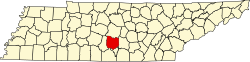
| County | Bedford |
| Elevation | 781 ft (238 m) |
| Time zone | UTC-6 (Central (CST)) |
| • Summer (DST) | UTC-5 (CDT) |
| ZIP code | 37160, 37091 |
| Area code | 931 |
| GNIS feature ID | 1274280 [1] |
Wheel is an unincorporated community in Bedford County, Tennessee. [1] It lies along State Route 64 west of Shelbyville.