Holston Mountain | |
---|---|
![]() Holston High Point as seen from Holston High Knob. | |
Highest point | |
Elevation | 4,280+ feet (1,305+ m)("Holston High Point" summit) |
Prominence | 1,600 ft (490 m) |
Coordinates | 36°26′N82°8′W / 36.433°N 82.133°W |
Geography | |
![]() | |
Location | Tennessee and Virginia, U.S. |
Parent range | Appalachian Mountains, Blue Ridge Mountains |
Topo map | USGS Keenburg |
Holston Mountain is a mountain ridge in Upper East Tennessee and southwest Virginia, in the United States. It is in the Blue Ridge Mountains part of the Appalachian Mountains. Holston Mountain is a very prominent ridge-type mountain in Tennessee's Ridge and Valley Region, about 28 miles (45 km) long, running from southwest to northeast, covering about 268 square miles (690 km2). Its highest summit is Holston High Point, on which a Federal Aviation Administration (FAA) aircraft navigational beacon is located, at an elevation of 4,280 feet (1,300 m) above mean sea level. The second and third highest points are Rye Patch Knob, at 4,260 feet (1,300 m) above mean sea level and Rich Knob, at 4,240 (1,292.3 m) above mean sea level respectively. The fourth highest point is Holston High Knob where an old dismantled Cherokee National Forest fire tower (now a Communications Tower) marks the elevation at 4,136 feet (1,261 m) above mean sea level.
Holston Mountain is located in the Cherokee National Forest. It is bounded on the northwest by South Holston Lake; on the southeast by Stoney Creek Valley, Shady Valley, and the Iron Mountains; on the northeast by the town of Damascus, Virginia; and on the southwest near the community of Biltmore, Tennessee.
The southern portion of Holston Mountain marks the boundary between Sullivan County and Carter County; the northern portion is between Sullivan and Johnson County. The small northernmost portion extends into Washington County, Virginia.
Panhandle Road is located off State Highway 91 in Carter County and ascends Holston Mountain for three miles (4.8 km) from the eastern side and ends four miles (6.4 km) along the ridge southwest of Holston High Point. During periods of heavy snow and ice, hunting season, or nesting season, the Tennessee Wildlife Resources Agency closes off Panhandle Road with an iron gate. Located near the Cherokee National Forest boundary and to the left of Panhandle Road is a parking area and foot trail that leads down the slope to the Blue Hole Falls (approximately 45 feet (14 m) high). The iron gate referred to above is there, owned and maintained by the Cherokee National Forest, Watauga Ranger District. No matter, though.. the last three miles (4.8 km) of Panhandle Road along the top of the ridge are filled with washouts, steep drop-offs, and no turnarounds. Vehicle travel on those last three miles (4.8 km) is at the driver's risk.
U.S. Route 421 crosses Holston Mountain at Low Gap, connecting the community of Shady Valley, Tennessee, with the city of Bristol, Tennessee.
Holston Mountain is named after the Holston River, which is named for Stephen Holston, a descendant of a Swede of New Sweden. Stephen Holston moved west and in 1746 built a cabin near the headwaters of a little creek. When surveyors were working in the area the next year they gave the creek the name "Holston's Creek", because Stephen Holston lived on it. Later pioneers followed the creek downstream where, after receiving many tributaries, it was wide enough to become a river and so it became known as the Holston River. George R. Stewart, describing this placename history, notes, "Thus one of the largest streams of that region came to bear the name of a common settler". Stewart goes on to note that the nearby Clinch River is likewise named for a "common settler". Unlike Holston, the identity of Clinch is unknown, except that Dr. Walker wrote of a stream called "Clinch's River from one Clinch, a hunter". [1]
October 4, 1976 Kingsport, Tennessee Daily News staff writer, Mark Aldeen, in an article entitled "Investigation Into Cause Of Plane Crash Continues", reported the crash landing of a USAF reconnaissance plane on Holston Mountain, 13.2 miles from the Tri-cites airport. The RF-4C "Phantom" carried two Airmen, neither of whom survived. [2]
September 1, 2007 The FAA says five Jehovah's Witnesses ministers from East Tennessee were killed when their small plane crashed in the Cherokee National Forest on Holston Mountain shortly after takeoff. A passing airplane spotted the smoldering wreckage around 7:00 p.m. Saturday about a mile and a half down the southern side of the mountain, from the Holston High Point broadcasting antenna farm.
The Appalachian Trail crosses over from Iron Mountain from the southeast side, then runs along the upper northeast end of Holston Mountain. The trail descends on the northeast end, sloping down the mountain into Virginia, the town of Damascus, and continues to Mount Rogers, the highest point in Virginia.
Early broadcasters in the 1950s and 1960s quickly realized Holston Mountain as a prime radio-television transmission location because it is the highest visible point that faces most of the major cities in Upper East Tennessee and Southwest Virginia in the surrounding valley between Knoxville, Tennessee, to southwest of Roanoke, Virginia. As a result, the Holston Mountain ridge is the transmitting site for five television stations in the Tri-Cities, Tennessee Television Designated Market Area (DMA). The digital broadcasting antenna for WCYB, digital Channel 5, Bristol, Virginia is on Rye Patch Knob, with the top of the antenna 341 feet (104 m) above ground, 2,431 feet (741 m) above the surrounding valley floor, and 4,533 feet (1,382 m) above mean sea level. The single tower that antenna sits on, is the highest and tallest man-made structure on the mountain, allowing the Virginia station to transmit from the highest broadcasting point in Tennessee, Virginia and Kentucky. The television towers for WJHL, digital Channel 11, Johnson City, Tennessee, and WKPT, digital Channel 19, Kingsport, Tennessee, are standing side by side in a common broadcasting antenna farm on the southwest slope of Holston High Point, one mile (1.6 km) southwest of Rye Patch Knob. The antenna for WJHL stands 200 feet (61 m) above ground, 2,319 feet (707 m) above the surrounding valley floor, and 4,370 feet (1,330 m) above mean sea level. The antenna for WKPT next door stands 193 feet (59 m) above ground, also 2,319 feet (707 m) above the valley floor, and 4,366 feet (1,331 m) above mean sea level.
The transmitter for WEMT, digital Channel 39, licensed to Greeneville, Tennessee was relocated from Camp Creek Bald (Viking Mountain) south of Greeneville to the WCYB digital tower on Rye Patch Knob, when ownership of WEMT was acquired by the Sinclair Broadcast Group, owners of WCYB.
Holston Mountain is also the transmitting site for three FM Class C radio stations: WTFM-FM 98.5, Kingsport, Tennessee; WXBQ-FM 96.9, Bristol, Virginia and WETS-FM 89.5, Johnson City, Tennessee. All three antennas and the backup antennas are located at the antenna farm on the southwest slope of Holston High Point. Also located on the ridge are the antenna for one FM Class C1 radio station, WHCB-FM 91.5, Bristol, Tennessee, located at Rye Patch Knob; one FM Class C2 antenna for radio station WCQR-FM 88.3, Kingsport, Tennessee, and one FM Class D antenna for radio station W214AP-FM 90.7, Johnson City, Tennessee, both transmitting from the antenna farm on the southwest slope of Holston High Point. Located further down the southwestern slope, off of Holston Mountain Road, is the transmitting site of FM Class C3 WEXX 99.3, Elizabethton, Tennessee. Various U.S. federal, Tennessee state, Sullivan, Washington and Carter County governmental agencies, along with utility microwave relay stations, also transmit base-to-mobile communications from the Holston High Point antenna farm and Rye Patch Knob.
Holston Mountain is also home to several amateur radios transmitter sites. wm4t repeater site sits on the highest peak of the mountain for two-way radio service. This site covers seven states in communications. The tower (shown below) is 120 feet self-supporting. It tops out with an antenna on top of 18 more feet.
The Holston Mountain collection of broadcast towers, commonly referred to as an "antenna farm" is a good example of radio and TV station owners, co-locating their broadcast towers near each other on the highest point near their FCC city of license. This marketing practice was borne during the 1950s, before cable and during a time when all homes had outside antennae to receive broadcast signals. When the viewer wanted to receive a clear picture or FM stereo from their favorite station, they would point their antennae toward that radio or TV station's broadcasting tower (usually on the highest mountain peak nearby). Other station owners realized the benefit of locating their transmitting towers near that one, to allow viewers to get clear signals from their stations, too. The nearest antenna farm to Holston Mountain is southwest to Sharp's Ridge, on which most of the FM and TV stations in the Knoxville, Tennessee Designated Market Area (DMA) have their antennas and towers. The next nearest from Holston Mountain is on Poor Mountain in Central Virginia, home to most of the FM and TV stations in the Roanoke, Virginia Radio and Television DMA. Although most radio and TV stations are in fierce competition with each other in their broadcast markets, they will often locate their broadcasting antennas very near each other, and in some cases, will even share land or towers with each other, in the interests of space, land availability, and the cost of putting a transmission building on top of a mountain.
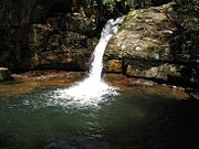
Elizabethton is a city in, and the county seat of Carter County, Tennessee, United States. Elizabethton is the historical site of the first independent American government located west of both the Eastern Continental Divide and the original Thirteen Colonies.
Sweat Mountain is a mountain in far northeastern Cobb County, Georgia, in the suburbs north of Atlanta. The exact GNIS location of its summit is 34°4′1″N84°27′20″W, and it has an official (USGS) elevation of 1,688 ft (515 m) above mean sea level. It is the second-highest point in the county behind Kennesaw Mountain, and second in the core metro Atlanta area, behind Kennesaw Mountain, which is also in Cobb County. It is fifth if the exurban counties further north are considered.
High Knob is the peak of Stone Mountain, that forms part of the border between Scott County and Wise County, Virginia, near the city of Norton that rises to 4,223 feet above mean sea level.
Mount Pisgah is a mountain in the Appalachian mountain range and part of the Blue Ridge Mountains of North Carolina, United States. The mountain's height is 5,721 feet above sea level, and it sits approximately 15 miles southwest of Asheville, near the crossing of the boundaries of Buncombe, Haywood, Henderson and Transylvania counties. It is located on the border of Buncombe and Haywood counties, close to the point where Henderson and Transylvania meet them, but not actually within the latter two counties. The mountain is easily accessible via a hiking trail from the Blue Ridge Parkway, near the Pisgah Inn.
WCYB-TV is a television station licensed to Bristol, Virginia, United States, serving the Tri-Cities area as an affiliate of NBC and The CW. It is one of two commercial television stations in the market that are licensed in Virginia. WCYB-TV is owned by the Sinclair Broadcast Group, which also provides certain services to Greeneville, Tennessee–licensed Fox affiliate WEMT under a local marketing agreement (LMA) with Cunningham Broadcasting. However, Sinclair effectively owns WEMT as the majority of Cunningham's stock is owned by the family of deceased group founder Julian Smith. The two stations share studios on Lee Street on the Virginia side of Bristol ; WCYB-TV's transmitter is located at Rye Patch Knob on Holston Mountain in the Cherokee National Forest.
WJHL-TV is a television station licensed to Johnson City, Tennessee, United States, serving the Tri-Cities area as an affiliate of CBS and ABC. The station is owned by Nexstar Media Group, and maintains studios on East Main Street in downtown Johnson City; its transmitter is located on Holston Mountain in the Cherokee National Forest.
WKPT-TV is a television station licensed to Kingsport, Tennessee, United States, serving the Tri-Cities area as an affiliate of Cozi TV. It is owned by Glenwood Communications Corporation alongside low-power Class A MeTV affiliate WAPK-CD and several radio stations, including WKPT. All of the outlets share studios on Commerce Street in downtown Kingsport; WKPT-TV's transmitter is located on Holston Mountain in the Cherokee National Forest.
WEMT is a television station licensed to Greeneville, Tennessee, United States, serving as the Fox affiliate for the Tri-Cities area. It is owned by Cunningham Broadcasting, which maintains a local marketing agreement (LMA) with Sinclair Broadcast Group, owner of Bristol, Virginia–licensed dual NBC/CW affiliate WCYB-TV, for the provision of certain services. However, Sinclair effectively owns WEMT; the majority of Cunningham's stock is owned by the family of deceased group founder Julian Smith. The two stations share studios on Lee Street on the Virginia side of Bristol ; WEMT's transmitter is located at Rye Patch Knob on Holston Mountain in the Cherokee National Forest.
Poor Mountain is a ridge of high peaks located in Roanoke County, Virginia and Montgomery County, Virginia. At 3,928 feet, Poor Mountain is the tallest mountain in the immediate area.
North Mountain is a mountain ridge within the Ridge-and-valley Appalachians in the U.S. states of Virginia and West Virginia.
Clinch Mountain is a mountain ridge in the U.S. states of Tennessee and Virginia, lying in the ridge-and-valley section of the Appalachian Mountains. From its southern terminus at Kitts Point, which lies at the intersection of Knox, Union and Grainger counties near Blaine, Tennessee, it runs in a generally east-northeasterly direction to Garden Mountain near Burke's Garden, Virginia. It separates the Clinch River basin to the north and the Holston River basin to the south.
Bays Mountain is a ridge of the Ridge-and-Valley Appalachians, located in East Tennessee. It runs southwest to northeast, from just south of Knoxville to Kingsport.
The Appalachian National Scenic Trail spans 14 U.S. states over its roughly 2,200 miles (3,500 km): Georgia, North Carolina, Tennessee, Virginia, West Virginia, Maryland, Pennsylvania, New Jersey, New York, Connecticut, Massachusetts, Vermont, New Hampshire, and Maine. The southern end is at Springer Mountain, Georgia, and it follows the ridgeline of the Appalachian Mountains, crossing many of its highest peaks and running almost continuously through wilderness before reaching the northern end at Mount Katahdin, Maine.
House Mountain is a mountain located in Corryton, Tennessee, United States, about 8 miles (13 km) northeast of Knoxville. Rising to an elevation of 2,064 feet (629 m) above sea level, House Mountain is the highest point in Knox County.
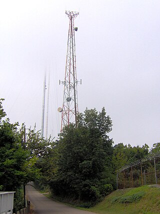
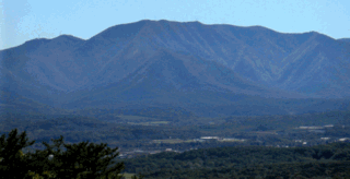
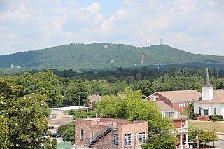
Sharp's Ridge is a steep ridge in Knoxville, Tennessee, north of the city's downtown. A 111-acre (45 ha) area of the 7-mile (11 km) ridge is maintained as Sharp's Ridge Memorial Park, a city park dedicated to the honor of the area's war veterans. The ridge also is the site of a transmitting antenna farm that serves most of Knoxville's broadcasters. The highest ground point on the ridge is an abandoned fire tower located at 1,391 feet (424 m) above mean sea level. The ridge itself averages 200 to 300 feet above the surrounding valley floor, allowing panoramic views of the Great Smoky Mountains and adjacent ranges to the east and the Cumberland Plateau and Cumberland Mountains to the west.
An antenna farm, satellite dish farm or dish farm is an area dedicated to television or radio telecommunications transmitting or receiving antenna equipment, such as C, Ku or Ka band satellite dish antennas, UHF/VHF/AM/FM transmitter towers or mobile cell towers. The history of the term "antenna farm" is uncertain, but it dates to at least the 1950s.
Shinall Mountain is a peak in Pulaski County, Arkansas, located in the foothills of the Ouachita Mountains on the western edge of Little Rock, the capital and most populous city of Arkansas. At an elevation of 1,056 feet (322 m) above mean sea level, it is the highest natural point in Pulaski County. Shinall Mountain is made of Carboniferous rocks, and plant fossils can sometimes be found in the blue-hued black shales comprising the sides of its bluff.
Sawnee Mountain is a low mountain between the piedmont and Appalachian foothills of the U.S. state of Georgia, north of Atlanta. Average rainfall/46.26in/yr/ average snowfall/5.7in/yr/. The name Sawnee Mountain actually refers to the entire ridge of approximately five miles (8 km) in length. At its summit, the elevation is 1,946 feet (593 m) above mean sea level, and is roughly 750 feet (230 m) above the surrounding terrain. The Sawnee Mountain range runs southwest to northeast, and consists of five knolls and three gaps. Located only a few miles north of Cumming, Georgia, the mountain is the highest point in Forsyth county at 1,946 ft above sea level. One of the highest peaks of metro Atlanta, it is taller than its more well-known neighbors Stone Mountain and Kennesaw Mountain by 260 ft and 138 ft respectively. Compared to other mountains in the area, however, Sawnee Mountain sits behind Bear Mountain and Pine Log Mountain, both in neighboring Cherokee County to the west.
Joppa is an unincorporated community in rural central-western Grainger County, Tennessee, United States. It rests below Joppa Mountain, a subrange located near the southern terminus of the 150 mile (240 km) long Clinch Mountain ridge complex, offering views of five U.S. States and the Great Smoky Mountains. Joppa is part of the Morristown, Tennessee Metropolitan Statistical Area, and also a component of the Knoxville-Morristown-Sevierville Combined Statistical Area.
The Path Grant Deed is a document regarded as a first step toward the American westward migration across the Appalachian Mountains, resulting from negotiations at Sycamore Shoals in March 1775. The land acquired within the boundaries of the Path Grant allowed Daniel Boone to develop the Wilderness Road free from attack or claims by the Cherokee. The Path Grant was recorded on November 15, 1794, by the Hawkins County, Tennessee registrar in Deed Book #1, pages 147-151