
Grayson County is a county located in the southwestern part of the Commonwealth of Virginia. As of the 2020 census, the population was 15,333. Its county seat is Independence. Mount Rogers, the state's highest peak at 5,729 feet (1,746 m), is in Grayson County.

Mount Mansfield is the highest mountain in Vermont, reaching an elevation of 4,393 feet (1,339 m) above sea level. Located in the northwest of the state, it is also the highest peak in the Green Mountains. Its summit is located within the town of Underhill in Chittenden County; the ridgeline, including some secondary peaks, extends into the town of Stowe in Lamoille County, and the mountain's flanks also reach into the town of Cambridge.

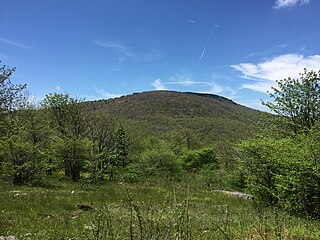
Mount Rogers is the highest natural point in Virginia, United States, with a summit elevation of 5,729 feet (1,746 m) above mean sea level. The summit straddles the border of Grayson and Smyth Counties, Virginia, about 6.45 miles (10.38 km) WSW of Troutdale, Virginia. Most of the mountain is contained within the Lewis Fork Wilderness, while the entire area is part of the Mount Rogers National Recreation Area, which itself is a part of the Jefferson National Forest.

The Taconic Mountains are a 150-mile-long sub-range of the Appalachian Mountains lying on the eastern border of New York State and adjacent New England. The range, which played a role in the history of geological science, is separated from the Berkshires and Green Mountains to the east by a series of valleys, principally those of the Housatonic River, Battenkill River and Otter Creek. The Taconics' highest point is Mount Equinox in Vermont at 3,840 feet (1,170 m); among many other summits are Dorset Mountain, Mount Greylock and Mount Everett.

The George Washington and Jefferson National Forests is an administrative entity combining two U.S. National Forests into one of the largest areas of public land in the Eastern United States. The forests cover 1.8 million acres (2,800 sq mi) of land in the Appalachian Mountains of Virginia, West Virginia, and Kentucky. Approximately 1 million acres (1,600 sq mi) of the forest are remote and undeveloped and 139,461 acres (218 sq mi) have been designated as wilderness areas, which prohibits future development.

High Knob is the peak of Stone Mountain, that forms part of the border between Scott County and Wise County, Virginia, near the city of Norton that rises to 4,223 feet above mean sea level.

Mount Rogers National Recreation Area is a United States national recreation area (NRA) in southwestern Virginia near the border with Tennessee and North Carolina. It centerpiece is the Lewis Fork Wilderness containing Mount Rogers, the highest point in the state of Virginia with a summit elevation of 5,729 feet. The recreation area is under the jurisdiction of the George Washington and Jefferson National Forests. The recreation area was established by an act of the United States Congress on May 31, 1966.

Mount Democrat is a high mountain summit in the Mosquito Range of the Rocky Mountains of North America. The 14,155-foot (4,314 m) fourteener is located 5.4 miles (8.7 km) northwest of the Town of Alma, Colorado, United States, near the Continental Divide separating San Isabel National Forest and Lake County from Pike National Forest and Park County.

Mount Jefferson is the highest mountain in both the Toquima Range and Nye County in Nevada, United States. It is the sixth highest mountain in the state. As the high point of a range which is well separated from other ranges by low basins, Mount Jefferson has a high topographic prominence of 5,861 feet (1,786 m). This makes it the most prominent peak in Nye County and the third most prominent peak in Nevada. For similar reasons, it is also the highest mountain for over 90 miles in all directions. It is located about 50 miles (80 km) northeast of the county seat of Tonopah within the Alta Toquima Wilderness of the Humboldt-Toiyabe National Forest, near the smaller towns of Carvers and Round Mountain. Three distinct summits are located on a broad area of subalpine tundra: North Summit rises to 11,820 feet (3,603 m), Middle Summit to 11,692 feet (3,564 m), and South Summit to 11,949 feet (3,642 m). During the Pleistocene, alpine glaciers eroded several cirques east of the summit plateau.

Mount Baldy is an extinct stratovolcano in eastern Arizona in the United States. With a summit elevation of 11,409 feet (3,477 m), the peak of Mount Baldy rises above the tree line and is left largely bare of vegetation, lending the mountain its current name. The Mount Baldy Wilderness occupies the eastern slope of the mountain and is managed by the Apache-Sitgreaves National Forest.

Mount Rose is the highest mountain in Washoe County, within the Carson Range of Nevada, United States. It ranks thirty-seventh among the most topographically prominent peaks in the state. It is also both the highest and most topographically prominent peak of the greater Sierra Nevada range within the state of Nevada, and the third most topographically prominent peak in the Sierra Nevada overall. It is located in the Mount Rose Wilderness of the Humboldt-Toiyabe National Forest. An extinct volcano, the mountain is in between Lake Tahoe and Reno. State Route 431 traverses Mount Rose Summit southeast of Mount Rose. Due to the high elevation, most of the precipitation that falls on the mountain is snow. The view from Mount Rose facing east is the Truckee Meadows, the second largest population center in Nevada.
Whitetop is an unincorporated community in Grayson County, Virginia, United States. It is the southern terminus of the Virginia Creeper Trail. Whitetop is named for nearby Whitetop Mountain, the second-tallest independent mountain in the State of Virginia, behind Mount Rogers. The town is about four miles northeast of the North Carolina–Tennessee–Virginia Corners.

The Lewis Fork Wilderness is an area in the Mount Rogers National Recreation Area protected by the Eastern Wilderness Act of Congress to maintain its present, natural condition. As part of the wilderness system, it is intended to preserve a variety of natural life forms and contribute to a diversity of plant and animal gene pools. Over half of the ecosystems in the United States exist within designated wilderness.
Shaw Gap is a wildland in the George Washington and Jefferson National Forests of western Virginia that has been recognized by the Wilderness Society as a special place worthy of protection from logging and road construction. The Wilderness Society has designated the area as a "Mountain Treasure".
Feathercamp is a wildland in the George Washington and Jefferson National Forests of western Virginia that has been recognized by the Wilderness Society as a special place worthy of protection from logging and road construction. The Wilderness Society has designated the area as a "Mountain Treasure".

Mount Rogers Crest Zone is a wildland in the George Washington and Jefferson National Forests of western Virginia that has been recognized by the Wilderness Society as a special place worthy of protection from logging and road construction. The Wilderness Society has designated the area as a "Mountain Treasure".
Whitetop Mountain (conservation area) is a wildland in the George Washington and Jefferson National Forests of western Virginia that has been recognized by the Wilderness Society as a special place worthy of protection from logging and road construction. The Wilderness Society has designated the area as a "Mountain Treasure".

Whitetop Laurel is a wildland in the George Washington and Jefferson National Forests of western Virginia that has been recognized by the Wilderness Society as a special place worthy of protection from logging and road construction. The Wilderness Society has designated the area as a "Mountain Treasure".

The Mount Rogers Cluster is a region recognized by The Wilderness Society for its unique high elevation mountains, vistas, trout streams and wildlife habitat. The heart of the region is Mount Rogers, the highest mountain in Virginia. The area extends over the Mount Rogers National Recreation Area and into part of the Cherokee National Forest.

Pine Mountain is a mountain in the Blue Ridge Mountains. It is located in the Mount Rogers National Recreation Area of the Jefferson National Forest, within Grayson County, Virginia, United States. The peak is immediately east of the highest mountain of Virginia, Mount Rogers, and Pine Mountain's sparsely vegetated summit has excellent views of both Mount Rogers and the surrounding region. The Appalachian Trail passes within feet of the summit. Pine Mountain is the second highest named summit in Virginia, though because its topographic prominence is well under 300 feet, it is considered a subsidiary peak of Mount Rogers.
