
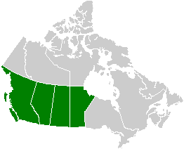
The Anahim Volcanic Belt (AVB) is a west–east trending chain of volcanoes and related magmatic features in British Columbia, Canada. It extends from Athlone Island on the Central Coast, running eastward through the strongly uplifted and deeply dissected Coast Mountains to near the community of Nazko on the Interior Plateau. The AVB is delineated as three west-to-east segments that differ in age and structure. A wide variety of igneous rocks with differing compositions occur throughout these segments, comprising landforms such as volcanic cones, volcanic plugs, lava domes, shield volcanoes and intrusions.

The Chilcotin Group, also called the Chilcotin Plateau Basalts, is a large area of basaltic lava that forms a volcanic plateau running parallel with the Garibaldi Volcanic Belt in south-central British Columbia, Canada.
The Rainbow Range, formerly gazetted as the Rainbow Mountains, is a mountain range in British Columbia, Canada, located 40 kilometres (25 mi) northwest of Anahim Lake. Located on the western edge of the Chilcotin Plateau, the range adjoins the Coast Mountains Pacific Ranges to the south, and the Kitimat Ranges to the north. In some classification systems it is considered part of the Coast Mountains. It lies north of the Bella Coola and Atnarko Rivers and south and west of the Dean River, which curves around its north flank, and is relatively drier in climate and easier of terrain than more mountainous areas immediately west.
Satah Mountain is a twin-peaked mountain in the West-Central Interior of British Columbia, Canada. It is southeast of Punkutlaenkut Lake and east of the community of Anahim Lake in Range 3 Coast Land District.

The Milbanke Sound Group, also called the Milbanke Sound Cones, is an enigmatic group of five small basaltic volcanoes in the Kitimat Ranges of the Coast Mountains in British Columbia, Canada. Named for Milbanke Sound, this volcanic group straddles on at least four small islands, including Swindle, Price, Lady Douglas and Lake Island. Not much is known about this group of volcanoes and they remain undated. However, they all likely formed in the past 10,000 years after the last glacial period as evidenced by a small amount of erosion. The age of the most recent volcanic activity is also unknown. Most of the Milbanke Sound Cones are covered by mature forest. Kitasu Hill and Helmet Peak are the only two cones that are officially named.
Tsitsutl Peak is the highest volcanic peak of the Rainbow Range in British Columbia, Canada, located within Tweedsmuir South Provincial Park, 43 km (27 mi) northwest of Anahim Lake and 44 km (27 mi) northeast of Thunder Mountain.
Black Dome Mountain is the northernmost summit of the Camelsfoot Range, which lies along the west side of the Fraser River, north of Lillooet, British Columbia, Canada. It is an ancient butte-like volcano located in the formation known as the Chilcotin Group, which lie between the Pacific Ranges of the Coast Mountains and the mid-Fraser River in British Columbia, Canada.

The Itcha Range, also known as the Itchas, is a small isolated mountain range in the West-Central Interior of British Columbia, Canada. It is located 40 km (25 mi) northeast of the community of Anahim Lake. With a maximum elevation of 2,375 m (7,792 ft), it is the lowest of three mountain ranges on the Chilcotin Plateau extending east from the Coast Mountains. Two mountains are named in the Itcha Range; Mount Downton and Itcha Mountain. A large provincial park surrounds the Itcha Range and other features in its vicinity. More than 15 animal species are known to exist in the Itcha Range area, as well as a grassland community that is limited only to this location of British Columbia. The Itcha Range is within territory which has been occupied by aboriginal peoples for millennia. This area has a relatively dry environment compared to the Coast Mountains in the west.

The Ilgachuz Range is a name given to an extinct shield volcano in British Columbia, Canada. It is not a mountain range in the normal sense, because it was formed as a single volcano that has been eroded for the past 5 million years. It lies on the Chilcotin Plateau, located some 350 kilometres (220 mi) north-northwest of Vancouver and 30 km north of Anahim Lake. The highest peak of the range is Far Mountain. The range supports a unique grassland ecosystem. This type of grassland has not been seen anywhere else in central and southern British Columbia. The climate is cool and dry; typical of higher elevations of the Interior Plateau.
Itcha Mountain is one of the two named volcanic peaks of the Itcha Range, which is located in the Chilcotin District of the Central Interior of British Columbia, Canada. It is in the Anahim Volcanic Belt, which formed when the North American Plate moved over a hotspot, similar to the one feeding the Hawaiian Islands. The Anahim Volcanic Belt includes other immediately nearby ranges, the Rainbow and Ilgachuz Ranges. Itcha Mountain is located 42 km (26 mi) northeast of Anahim Lake and 2 km (1 mi) northeast of Mount Downton, another peak of the Itcha Range. Both of these peaks are located within Itcha Ilgachuz Provincial Park, as is Far Mountain, the park's highest peak.
The Anahim hotspot is a hypothesized hotspot in the Central Interior of British Columbia, Canada. It has been proposed as the candidate source for volcanism in the Anahim Volcanic Belt, a 300 kilometres long chain of volcanoes and other magmatic features that have undergone erosion. This chain extends from the community of Bella Bella in the west to near the small city of Quesnel in the east. While most volcanoes are created by geological activity at tectonic plate boundaries, the Anahim hotspot is located hundreds of kilometres away from the nearest plate boundary.
Far Mountain is the highest of over 13 peaks in the Ilgachuz Range in the Anahim Volcanic Belt in British Columbia, Canada. The Ilgachuz Range is one of the three major shield volcanoes that formed the Anahim Volcanic Belt when the North American Plate moved over a hotspot. This is similar to the one which feeds the Hawaiian Islands. The mountain is located in the western part of Itcha Ilgachuz Provincial Park.

Anahim Peak, also spelled Anaham, ʔAnaghim, or Anaheim, is a volcanic cone in the Anahim Volcanic Belt in British Columbia, Canada, located 39 km (24 mi) northwest of Anahim Lake and 11 km (7 mi) east of Tsitsutl Peak. It was formed when the North American Plate moved over a hotspot, similar to the one feeding the Hawaiian Islands, called the Anahim hotspot. It is one of the several volcanoes in the Anahim Volcanic Belt that stands out all by itself, rising from the Chilcotin Plateau, between the Rainbow Range and the Ilgachuz Range and near the headwaters of the Dean River.
Mount Downton is the highest summit of the 10 km (6 mi) diameter Itcha Range, located 40 km (25 mi) northeast of Anahim Lake and 33 km (21 mi) east of Far Mountain in the Chilcotin District of the Central Interior of British Columbia, Canada. It lies within Itcha Ilgachuz Provincial Park.
Basalt Falls is a waterfall on the Dean River in the Chilcotin District of the Central Interior of British Columbia, located north of the community of Anahim Lake. It is approximately 12 feet (3.7 m) in height and is composed of columnar basalt of the Chilcotin Group.

Lava Canyon is a canyon on the Chilko River in the Chilcotin District of the Interior of British Columbia, Canada, located about 35 kilometres below the Chilko's outflow from the foot of Chilko Lake.
Volcanism of Western Canada has produced lava flows, lava plateaus, lava domes, cinder cones, stratovolcanoes, shield volcanoes, greenstone belts, submarine volcanoes, calderas, diatremes and maars, along with examples of more less common volcanic forms such as tuyas and subglacial mounds.
The Satah Mountain volcanic field (SMVF) is an extensive north-south trending volcanic chain in the Central Interior of British Columbia that stretches south of the Itcha Range shield volcano to northeast of Nimpo Lake. The chain is located on the Chilcotin Plateau, a major subdivision of the Interior Plateau that includes other nearby volcanic features. It forms a segment of the east-west trending Anahim Volcanic Belt, whose volcanic activity ranges in age from Miocene-to-Holocene.
Baldface Mountain is a conical butte-like summit in the West-Central Interior of British Columbia, Canada. It is east of Itcha Lake and northeast of the community of Anahim Lake in Range 3 Coast Land District.
The Baldface Mountain volcanic field is a volcanic field in the Central Interior of British Columbia, Canada. It is located about 25 km (16 mi) east of the Itcha Range on the Chilcotin Plateau. The volcanic field contains at least eight volcanic cones and is one of two volcanic fields in the Anahim Volcanic Belt, the other being the Satah Mountain volcanic field which extends south from the Itcha Range.

