
Rhyolite is the most silica-rich of volcanic rocks. It is generally glassy or fine-grained (aphanitic) in texture, but may be porphyritic, containing larger mineral crystals (phenocrysts) in an otherwise fine-grained groundmass. The mineral assemblage is predominantly quartz, sanidine, and plagioclase. It is the extrusive equivalent of granite.
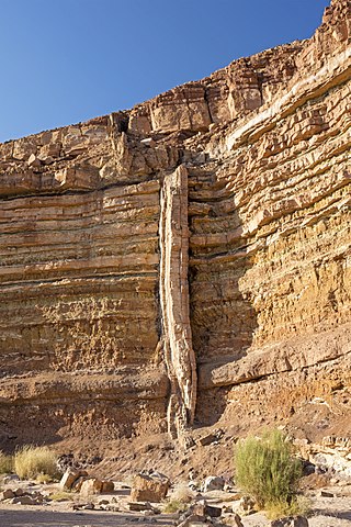
In geology, a dike or dyke is a sheet of rock that is formed in a fracture of a pre-existing rock body. Dikes can be either magmatic or sedimentary in origin. Magmatic dikes form when magma flows into a crack then solidifies as a sheet intrusion, either cutting across layers of rock or through a contiguous mass of rock. Clastic dikes are formed when sediment fills a pre-existing crack.

The Anahim Volcanic Belt (AVB) is a west–east trending chain of volcanoes and related magmatic features in British Columbia, Canada. It extends from Athlone Island on the Central Coast, running eastward through the strongly uplifted and deeply dissected Coast Mountains to near the community of Nazko on the Interior Plateau. The AVB is delineated as three west-to-east segments that differ in age and structure. A wide variety of igneous rocks with differing compositions occur throughout these segments, comprising landforms such as volcanic cones, volcanic plugs, lava domes, shield volcanoes and intrusions.
The Rainbow Range, formerly gazetted as the Rainbow Mountains, is a mountain range in British Columbia, Canada, located 40 kilometres (25 mi) northwest of Anahim Lake. Located on the western edge of the Chilcotin Plateau, the range adjoins the Coast Mountains Pacific Ranges to the south, and the Kitimat Ranges to the north. In some classification systems it is considered part of the Coast Mountains. It lies north of the Bella Coola and Atnarko Rivers and south and west of the Dean River, which curves around its north flank, and is relatively drier in climate and easier of terrain than more mountainous areas immediately west.

The Northern Cordilleran Volcanic Province (NCVP), formerly known as the Stikine Volcanic Belt, is a geologic province defined by the occurrence of Miocene to Holocene volcanoes in the Pacific Northwest of North America. This belt of volcanoes extends roughly north-northwest from northwestern British Columbia and the Alaska Panhandle through Yukon to the Southeast Fairbanks Census Area of far eastern Alaska, in a corridor hundreds of kilometres wide. It is the most recently defined volcanic province in the Western Cordillera. It has formed due to extensional cracking of the North American continent—similar to other on-land extensional volcanic zones, including the Basin and Range Province and the East African Rift. Although taking its name from the Western Cordillera, this term is a geologic grouping rather than a geographic one. The southmost part of the NCVP has more, and larger, volcanoes than does the rest of the NCVP; further north it is less clearly delineated, describing a large arch that sways westward through central Yukon.

Nazko Cone is a small potentially active basaltic cinder cone in central British Columbia, Canada, located 75 km west of Quesnel and 150 kilometers southwest of Prince George. It is considered the easternmost volcano in the Anahim Volcanic Belt. The small tree-covered cone rises 120 m above the Chilcotin-Nechako Plateau and rests on glacial till. It was formed in three episodes of activity, the first of which took place during the Pleistocene interglacial stage about 340,000 years ago. The second stage produced a large hyaloclastite scoria mound erupted beneath the Cordilleran Ice Sheet during the Pleistocene. Its last eruption produced two small lava flows that traveled 1 km to the west, along with a blanket of volcanic ash that extends several km to the north and east of the cone.

The Milbanke Sound Group, also called the Milbanke Sound Cones, is an enigmatic group of five small basaltic volcanoes in the Kitimat Ranges of the Coast Mountains in British Columbia, Canada. Named for Milbanke Sound, this volcanic group straddles on at least four small islands, including Swindle, Price, Lady Douglas and Lake Island. Not much is known about this group of volcanoes and they remain undated. However, they all likely formed in the past 10,000 years after the last glacial period as evidenced by a small amount of erosion. The age of the most recent volcanic activity is also unknown. Most of the Milbanke Sound Cones are covered by mature forest. Kitasu Hill and Helmet Peak are the only two cones that are officially named.

The Itcha Range, also known as the Itchas, is a small isolated mountain range in the West-Central Interior of British Columbia, Canada. It is located 40 km (25 mi) northeast of the community of Anahim Lake. With a maximum elevation of 2,375 m (7,792 ft), it is the lowest of three mountain ranges on the Chilcotin Plateau extending east from the Coast Mountains. Two mountains are named in the Itcha Range; Mount Downton and Itcha Mountain. A large provincial park surrounds the Itcha Range and other features in its vicinity. More than 15 animal species are known to exist in the Itcha Range area, as well as a grassland community that is limited only to this location of British Columbia. The Itcha Range is within territory which has been occupied by aboriginal peoples for millennia. This area has a relatively dry environment compared to the Coast Mountains in the west.
Volcanic activity is a major part of the geology of Canada and is characterized by many types of volcanic landform, including lava flows, volcanic plateaus, lava domes, cinder cones, stratovolcanoes, shield volcanoes, submarine volcanoes, calderas, diatremes, and maars, along with less common volcanic forms such as tuyas and subglacial mounds.

A volcanic belt is a large volcanically active region. Other terms are used for smaller areas of activity, such as volcanic fields or volcanic systems. Volcanic belts are found above zones of unusually high temperature where magma is created by partial melting of solid material in the Earth's crust and upper mantle. These areas usually form along tectonic plate boundaries at depths of 10 to 50 kilometres. For example, volcanoes in Mexico and western North America are mostly in volcanic belts, such as the Trans-Mexican Volcanic Belt that extends 900 kilometres (560 mi) from west to east across central-southern Mexico and the Northern Cordilleran Volcanic Province in western Canada. In the case of Iceland, the geologist G.G. Bárdarson in 1929 identified clusters of volcanic belts while studying the Reykjanes Peninsula.

The Ilgachuz Range is a name given to an extinct shield volcano in British Columbia, Canada. It is not a mountain range in the normal sense, because it was formed as a single volcano that has been eroded for the past 5 million years. It lies on the Chilcotin Plateau, located some 350 kilometres (220 mi) north-northwest of Vancouver and 30 km north of Anahim Lake. The highest peak of the range is Far Mountain. The range supports a unique grassland ecosystem. This type of grassland has not been seen anywhere else in central and southern British Columbia. The climate is cool and dry; typical of higher elevations of the Interior Plateau.
The Anahim hotspot is a hypothesized hotspot in the Central Interior of British Columbia, Canada. It has been proposed as the candidate source for volcanism in the Anahim Volcanic Belt, a 300 kilometres long chain of volcanoes and other magmatic features that have undergone erosion. This chain extends from the community of Bella Bella in the west to near the small city of Quesnel in the east. While most volcanoes are created by geological activity at tectonic plate boundaries, the Anahim hotspot is located hundreds of kilometres away from the nearest plate boundary.

A dike swarm or dyke swarm is a large geological structure consisting of a major group of parallel, linear, or radially oriented magmatic dikes intruded within continental crust or central volcanoes in rift zones. Examples exist in Iceland and near other large volcanoes, around the world. They consist of several to hundreds of dikes emplaced more or less contemporaneously during a single intrusive event, are magmatic and stratigraphic, and may form a large igneous province.

The Silverthrone Caldera is a potentially active caldera complex in southwestern British Columbia, Canada, located over 350 kilometres (220 mi) northwest of the city of Vancouver and about 50 kilometres (31 mi) west of Mount Waddington in the Pacific Ranges of the Coast Mountains. The caldera is one of the largest of the few calderas in western Canada, measuring about 30 kilometres (19 mi) long (north-south) and 20 kilometres (12 mi) wide (east-west). Mount Silverthrone, an eroded lava dome on the caldera's northern flank that is 2,864 metres (9,396 ft) high, may be the highest volcano in Canada.

The Wells Gray-Clearwater volcanic field, also called the Clearwater Cone Group, is a potentially active monogenetic volcanic field in east-central British Columbia, Canada, located approximately 130 km (81 mi) north of Kamloops. It is situated in the Cariboo Mountains of the Columbia Mountains and on the Quesnel and Shuswap Highlands. As a monogenetic volcanic field, it is a place with numerous small basaltic volcanoes and extensive lava flows.

The Coast Range Arc was a large volcanic arc system, extending from northern Washington through British Columbia and the Alaska Panhandle to southwestern Yukon. The Coast Range Arc lies along the western margin of the North American Plate in the Pacific Northwest of western North America. Although taking its name from the Coast Mountains, this term is a geologic grouping rather than a geographic one, and the Coast Range Arc extended south into the High Cascades of the Cascade Range, past the Fraser River which is the northward limit of the Cascade Range proper.
A series of small volcanic earthquakes measuring less than 4.0 on the Richter magnitude scale took place in the sparsely populated Nazko area of the Central Interior of British Columbia, Canada, from October 9, 2007, to June 12, 2008. They occurred just west of Nazko Cone, a small tree-covered cinder cone that last erupted about 7,200 years ago.
Jack Gordon Souther was an American-born Canadian geologist, volcanologist, professor and engineer. He contributed significantly to the early understanding of recent volcanic activity in the Canadian Cordillera. Many of his publications continue to be regarded as classics in their field, even now several decades after they were written.

The King Island Pluton is a mid-to-late Miocene intrusion of syenite and alkali granite on the Central Coast of British Columbia, Canada. It is over 20 km (12 mi) long and 2.5 km (1.6 mi) wide, extending from King Island in the west to the mainland in the east. The pluton is exposed in 1,000 m (3,300 ft) cliffs along the Dean and Burke channels west of Bella Coola.

Phonotephrite or phono-tephrite is a strongly alkaline volcanic rock with a composition between phonolite and tephrite. This unusual igneous rock contains 7 to 12% alkali content and 45 to 53% silica content. It can be described as a mafic phonolite or a potassic tephrite. Phonotephrite lava flows and volcanic cones have been identified in Antarctica, Europe, North America and Africa.
