
The Anahim Volcanic Belt (AVB) is a west–east trending chain of volcanoes and related magmatic features in British Columbia, Canada. It extends from Athlone Island on the Central Coast, running eastward through the strongly uplifted and deeply dissected Coast Mountains to near the community of Nazko on the Interior Plateau. The AVB is delineated as three west-to-east segments that differ in age and structure. A wide variety of igneous rocks with differing compositions occur throughout these segments, comprising landforms such as volcanic cones, volcanic plugs, lava domes, shield volcanoes and intrusions.

The Chilcotin Group, also called the Chilcotin Plateau Basalts, is a large area of basaltic lava that forms a volcanic plateau running parallel with the Garibaldi Volcanic Belt in south-central British Columbia, Canada.
The Rainbow Range, formerly gazetted as the Rainbow Mountains, is a mountain range in British Columbia, Canada, located 40 kilometres (25 mi) northwest of Anahim Lake. Located on the western edge of the Chilcotin Plateau, the range adjoins the Coast Mountains Pacific Ranges to the south, and the Kitimat Ranges to the north. In some classification systems it is considered part of the Coast Mountains. It lies north of the Bella Coola and Atnarko Rivers and south and west of the Dean River, which curves around its north flank, and is relatively drier in climate and easier of terrain than more mountainous areas immediately west.
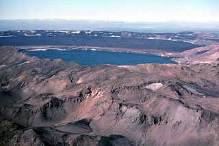
Itcha Ilgachuz Provincial Park is a provincial park in the Chilcotin Country of British Columbia, Canada. The park is 111,977 hectares in size and contains Far Mountain and Mount Downton, its two most prominent peaks.
Satah Mountain is a twin-peaked mountain in the West-Central Interior of British Columbia, Canada. It is southeast of Punkutlaenkut Lake and east of the community of Anahim Lake in Range 3 Coast Land District.

Nazko Cone is a small potentially active basaltic cinder cone in central British Columbia, Canada, located 75 km west of Quesnel and 150 kilometers southwest of Prince George. It is considered the easternmost volcano in the Anahim Volcanic Belt. The small tree-covered cone rises 120 m above the Chilcotin-Nechako Plateau and rests on glacial till. It was formed in three episodes of activity, the first of which took place during the Pleistocene interglacial stage about 340,000 years ago. The second stage produced a large hyaloclastite scoria mound erupted beneath the Cordilleran Ice Sheet during the Pleistocene. Its last eruption produced two small lava flows that traveled 1 km to the west, along with a blanket of volcanic ash that extends several km to the north and east of the cone.
Tsitsutl Peak is the highest volcanic peak of the Rainbow Range in British Columbia, Canada, located within Tweedsmuir South Provincial Park, 43 km (27 mi) northwest of Anahim Lake and 44 km (27 mi) northeast of Thunder Mountain.

The Itcha Range, also known as the Itchas, is a small isolated mountain range in the West-Central Interior of British Columbia, Canada. It is located 40 km (25 mi) northeast of the community of Anahim Lake. With a maximum elevation of 2,375 m (7,792 ft), it is the lowest of three mountain ranges on the Chilcotin Plateau extending east from the Coast Mountains. Two mountains are named in the Itcha Range; Mount Downton and Itcha Mountain. A large provincial park surrounds the Itcha Range and other features in its vicinity. More than 15 animal species are known to exist in the Itcha Range area, as well as a grassland community that is limited only to this location of British Columbia. The Itcha Range is within territory which has been occupied by aboriginal peoples for millennia. This area has a relatively dry environment compared to the Coast Mountains in the west.

The Ilgachuz Range is a name given to an extinct shield volcano in British Columbia, Canada. It is not a mountain range in the normal sense, because it was formed as a single volcano that has been eroded for the past 5 million years. It lies on the Chilcotin Plateau, located some 350 kilometres (220 mi) north-northwest of Vancouver and 30 km north of Anahim Lake. The highest peak of the range is Far Mountain. The range supports a unique grassland ecosystem. This type of grassland has not been seen anywhere else in central and southern British Columbia. The climate is cool and dry; typical of higher elevations of the Interior Plateau.
The Anahim hotspot is a hypothesized hotspot in the Central Interior of British Columbia, Canada. It has been proposed as the candidate source for volcanism in the Anahim Volcanic Belt, a 300 kilometres long chain of volcanoes and other magmatic features that have undergone erosion. This chain extends from the community of Bella Bella in the west to near the small city of Quesnel in the east. While most volcanoes are created by geological activity at tectonic plate boundaries, the Anahim hotspot is located hundreds of kilometres away from the nearest plate boundary.
Far Mountain is the highest of over 13 peaks in the Ilgachuz Range in the Anahim Volcanic Belt in British Columbia, Canada. The Ilgachuz Range is one of the three major shield volcanoes that formed the Anahim Volcanic Belt when the North American Plate moved over a hotspot. This is similar to the one which feeds the Hawaiian Islands. The mountain is located in the western part of Itcha Ilgachuz Provincial Park.

Anahim Peak, also spelled Anaham, ʔAnaghim, or Anaheim, is a volcanic cone in the Anahim Volcanic Belt in British Columbia, Canada, located 39 km (24 mi) northwest of Anahim Lake and 11 km (7 mi) east of Tsitsutl Peak. It was formed when the North American Plate moved over a hotspot, similar to the one feeding the Hawaiian Islands, called the Anahim hotspot. It is one of the several volcanoes in the Anahim Volcanic Belt that stands out all by itself, rising from the Chilcotin Plateau, between the Rainbow Range and the Ilgachuz Range and near the headwaters of the Dean River.

The geology of the Pacific Northwest includes the composition, structure, physical properties and the processes that shape the Pacific Northwest region of North America. The region is part of the Ring of Fire: the subduction of the Pacific and Farallon Plates under the North American Plate is responsible for many of the area's scenic features as well as some of its hazards, such as volcanoes, earthquakes, and landslides.
Mount Downton is the highest summit of the 10 km (6 mi) diameter Itcha Range, located 40 km (25 mi) northeast of Anahim Lake and 33 km (21 mi) east of Far Mountain in the Chilcotin District of the Central Interior of British Columbia, Canada. It lies within Itcha Ilgachuz Provincial Park.
Mount MacKenzie is a volcanic peak, located 40 km (25 mi) northeast of Hagensborg, British Columbia, Canada. It is one of the volcanic peaks of the Rainbow Range, which is one of the three major shield volcanoes that form the Anahim Volcanic Belt. Mount MacKenzie was formed when the North American Plate moved over a hotspot, similar to the one feeding the Hawaiian Islands, known as the Anahim hotspot.
A series of small volcanic earthquakes measuring less than 4.0 on the Richter magnitude scale took place in the sparsely populated Nazko area of the Central Interior of British Columbia, Canada, from October 9, 2007, to June 12, 2008. They occurred just west of Nazko Cone, a small tree-covered cinder cone that last erupted about 7,200 years ago.
The Satah Mountain volcanic field (SMVF) is an extensive north-south trending volcanic chain in the Central Interior of British Columbia that stretches south of the Itcha Range shield volcano to northeast of Nimpo Lake. The chain is located on the Chilcotin Plateau, a major subdivision of the Interior Plateau that includes other nearby volcanic features. It forms a segment of the east-west trending Anahim Volcanic Belt, whose volcanic activity ranges in age from Miocene-to-Holocene.
Baldface Mountain is a conical butte-like summit in the West-Central Interior of British Columbia, Canada. It is east of Itcha Lake and northeast of the community of Anahim Lake in Range 3 Coast Land District.
The Baldface Mountain volcanic field is a volcanic field in the Central Interior of British Columbia, Canada. It is located about 25 km (16 mi) east of the Itcha Range on the Chilcotin Plateau. The volcanic field contains at least eight volcanic cones and is one of two volcanic fields in the Anahim Volcanic Belt, the other being the Satah Mountain volcanic field which extends south from the Itcha Range.
A central volcano is a type of volcano formed by basalts and silica-rich volcanic rocks. They contain very few or no volcanic rocks of intermediate composition, such that they are chemically bimodal. Large silicic eruptions at central volcanoes often result in the formation of one or more calderas. Central volcanoes can be stratovolcanoes or shield volcanoes.
