The Dakelh or Carrier are the indigenous people of a large portion of the Central Interior of British Columbia, Canada. Another name the Dakelh/Carrier call themselves is Yinka Dene, the Babine-Witsuwitʼen-speaking bands prefer the equivalent Yinka Whut'en.

The Anahim Volcanic Belt (AVB) is a west–east trending chain of volcanoes and related magmatic features in British Columbia, Canada. It extends from Athlone Island on the Central Coast, running eastward through the strongly uplifted and deeply dissected Coast Mountains to near the community of Nazko on the Interior Plateau. The AVB is delineated as three west-to-east segments that differ in age and structure. A wide variety of igneous rocks with differing compositions occur throughout these segments, comprising landforms such as volcanic cones, volcanic plugs, lava domes, shield volcanoes and intrusions.

The Chilcotin Group, also called the Chilcotin Plateau Basalts, is a large area of basaltic lava that forms a volcanic plateau running parallel with the Garibaldi Volcanic Belt in south-central British Columbia, Canada.
The Tsilhqotʼin or Chilcotin are a North American tribal government of the Athabaskan-speaking ethnolinguistic group that live in what is now known as British Columbia, Canada. They are the most southern of the Athabaskan-speaking Indigenous peoples in British Columbia.

Bella Coola is an unincorporated community in the Bella Coola Valley of British Columbia, Canada. Bella Coola usually refers to the entire valley, encompassing the settlements of Bella Coola proper, Lower Bella Coola, Hagensborg, Salloompt, Nusatsum, Firvale, and Stuie. It is also the location of the head offices of the Central Coast Regional District.
The Rainbow Range, formerly gazetted as the Rainbow Mountains, is a mountain range in British Columbia, Canada, located 40 kilometres (25 mi) northwest of Anahim Lake. Located on the western edge of the Chilcotin Plateau, the range adjoins the Coast Mountains Pacific Ranges to the south, and the Kitimat Ranges to the north. In some classification systems it is considered part of the Coast Mountains. It lies north of the Bella Coola and Atnarko Rivers and south and west of the Dean River, which curves around its north flank, and is relatively drier in climate and easier of terrain than more mountainous areas immediately west.
The Bella Coola River is a major river on the Pacific slope of the Coast Mountains in southern British Columbia. The town of Bella Coola is at its mouth on North Bentinck Arm. Bella Coola Indian Reserve No. 1 is the location of the main community today of the surviving population of the Nuxalk who gathered there after depredations by smallpox and colonialization.
Tweedsmuir South Provincial Park is a provincial park covering parts of the eastern Kitimat Ranges, northern Pacific Ranges, and the Rainbow Range in British Columbia, Canada. It was established on May 21, 1938 in the western interior of the province, to protect its important natural features. The park hosts a variety of recreation activities for visitors. This park encompasses a range of diverse species in this park including bears, moose, and various fish. There are also a few at risk species in this park.
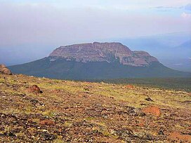
Satah Mountain is a twin-peaked mountain in the West-Central Interior of British Columbia, Canada. It is southeast of Punkutlaenkut Lake and east of the community of Anahim Lake in Range 3 Coast Land District.

The Milbanke Sound Group, also called the Milbanke Sound Cones, is an enigmatic group of five small basaltic volcanoes in the Kitimat Ranges of the Coast Mountains in British Columbia, Canada. Named for Milbanke Sound, this volcanic group straddles on at least four small islands, including Swindle, Price, Lady Douglas and Lake Island. Not much is known about this group of volcanoes and they remain undated. However, they all likely formed in the past 10,000 years after the last glacial period as evidenced by a small amount of erosion. The age of the most recent volcanic activity is also unknown. Most of the Milbanke Sound Cones are covered by mature forest. Kitasu Hill and Helmet Peak are the only two cones that are officially named.
Tsitsutl Peak is the highest volcanic peak of the Rainbow Range in British Columbia, Canada, located within Tweedsmuir South Provincial Park, 43 km (27 mi) northwest of Anahim Lake and 44 km (27 mi) northeast of Thunder Mountain.

The Itcha Range, also known as the Itchas, is a small isolated mountain range in the West-Central Interior of British Columbia, Canada. It is located 40 km (25 mi) northeast of the community of Anahim Lake. With a maximum elevation of 2,375 m (7,792 ft), it is the lowest of three mountain ranges on the Chilcotin Plateau extending east from the Coast Mountains. Two mountains are named in the Itcha Range; Mount Downton and Itcha Mountain. A large provincial park surrounds the Itcha Range and other features in its vicinity. More than 15 animal species are known to exist in the Itcha Range area, as well as a grassland community that is limited only to this location of British Columbia. The Itcha Range is within territory which has been occupied by aboriginal peoples for millennia. This area has a relatively dry environment compared to the Coast Mountains in the west.

The Ilgachuz Range is a name given to an extinct shield volcano in British Columbia, Canada. It is not a mountain range in the normal sense, because it was formed as a single volcano that has been eroded for the past 5 million years. It lies on the Chilcotin Plateau, located some 350 kilometres (220 mi) north-northwest of Vancouver and 30 km north of Anahim Lake. The highest peak of the range is Far Mountain. The range supports a unique grassland ecosystem. This type of grassland has not been seen anywhere else in central and southern British Columbia. The climate is cool and dry; typical of higher elevations of the Interior Plateau.
Itcha Mountain is one of the two named volcanic peaks of the Itcha Range, which is located in the Chilcotin District of the Central Interior of British Columbia, Canada. It is in the Anahim Volcanic Belt, which formed when the North American Plate moved over a hotspot, similar to the one feeding the Hawaiian Islands. The Anahim Volcanic Belt includes other immediately nearby ranges, the Rainbow and Ilgachuz Ranges. Itcha Mountain is located 42 km (26 mi) northeast of Anahim Lake and 2 km (1 mi) northeast of Mount Downton, another peak of the Itcha Range. Both of these peaks are located within Itcha Ilgachuz Provincial Park, as is Far Mountain, the park's highest peak.
The Anahim hotspot is a hypothesized hotspot in the Central Interior of British Columbia, Canada. It has been proposed as the candidate source for volcanism in the Anahim Volcanic Belt, a 300 kilometres long chain of volcanoes and other magmatic features that have undergone erosion. This chain extends from the community of Bella Bella in the west to near the small city of Quesnel in the east. While most volcanoes are created by geological activity at tectonic plate boundaries, the Anahim hotspot is located hundreds of kilometres away from the nearest plate boundary.
Far Mountain is the highest of over 13 peaks in the Ilgachuz Range in the Anahim Volcanic Belt in British Columbia, Canada. The Ilgachuz Range is one of the three major shield volcanoes that formed the Anahim Volcanic Belt when the North American Plate moved over a hotspot. This is similar to the one which feeds the Hawaiian Islands. The mountain is located in the western part of Itcha Ilgachuz Provincial Park.
Mount Downton is the highest summit of the 10 km (6 mi) diameter Itcha Range, located 40 km (25 mi) northeast of Anahim Lake and 33 km (21 mi) east of Far Mountain in the Chilcotin District of the Central Interior of British Columbia, Canada. It lies within Itcha Ilgachuz Provincial Park.

Anahim Lake is a small community in British Columbia. The village and surrounding areas have a population of approximately 1500. The Ulkatcho First Nation has 729 people living on nearby reserves. Every July, the Anahim Lake Stampede showcases local talent and is the area's major social event. Anahim Lake supports three general stores, one motel, a restaurant, and an RCMP detachment. It is situated on Highway 20, 320 km west of Williams Lake, 140 km east of Bella Coola.
Mount MacKenzie is a volcanic peak, located 40 km (25 mi) northeast of Hagensborg, British Columbia, Canada. It is one of the volcanic peaks of the Rainbow Range, which is one of the three major shield volcanoes that form the Anahim Volcanic Belt. Mount MacKenzie was formed when the North American Plate moved over a hotspot, similar to the one feeding the Hawaiian Islands, known as the Anahim hotspot.
Anahim is a name used for several features in British Columbia, Canada, derived from the name of Chief Anahim, a leader of the Tsilhqot'in people in the mid-19th Century: