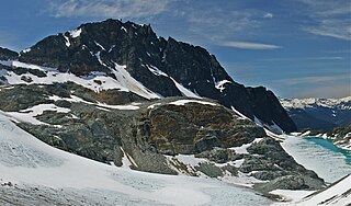
The Spearhead is a 2,457 m (8,061 ft) peak in the Garibaldi Ranges of British Columbia, Canada, and is one of the main summits of the Blackcomb Mountain portion of the Whistler Blackcomb ski resort, located at the apex of the Blackcomb and Spearhead Glaciers, which is named for it. It also is the namesake of the Spearhead Range, which is the short range flanking the north side of Fitzsimmons Creek and ending on its northwest end at Blackcomb Mountain. The mountain's name was officially adopted on August 27, 1965, by the Geographical Names Board of Canada.

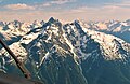
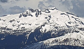
Mount Tantalus is a 2,608-metre (8,556-foot) mountain in southwestern British Columbia, Canada, located 24 km (15 mi) southeast of Falk Lake and 134 km (83 mi) south of Monmouth Mountain. It is the highest mountain in the Tantalus Range of the Pacific Ranges and is famous for its snow-covered face.

Rainbow Mountain is a broad glaciated mountain forming the northeastern wall of the Callaghan Valley in the Pacific Ranges of British Columbia, Canada. Located in the middle of the Sea to Sky Country, the mountain is just 9 km (5.6 mi) northwest of the resort town of Whistler, and is a popular destination for hiking, snowshoeing and ski touring.
Tricouni Peak is a mountain located south of Cypress Peak on the Squamish-Cheakamus divide within the Pacific Ranges of the Coast Mountains in southwestern British Columbia, Canada. It was named in 1931 by Tom Fyles et al., the first ascent party. According to Tom Fyles himself, "Tricouni Mountain was the name suggested for the peak, as from a distance it had the appearance of three cones". A misinterpreted "resemblance to a 3-pointed tricouni boot nail" was mentioned only much later, and not by Fyles. The name "Tricouni Peak" was adopted on 22 June 1967.
Mamquam Mountain is a mountain in the Pacific Ranges of the Coast Mountains in southwestern British Columbia, Canada, located 6 km (3.7 mi) southeast of Eanastick Meadows and 22 km (14 mi) east of Brackendale. It represents the highest summit of the Mamquam Icefield and lies at the southern end of Garibaldi Provincial Park. Mamquam Mountain was named on September 2, 1930, in association with the Mamquam River.
Fissile Peak, formerly known as Red Mountain, is a mountain peak located on the eastern side of Cheakamus Lake southeast of Whistler in Garibaldi Provincial Park of British Columbia, Canada. The mountain is composed of red slate which is easily divided into thin sheets of uniform thickness; in geological terms this feature is known as fissility.

Defiance Mountain is a 2,659-metre-elevation (8,724-foot) summit in the northernmost Pacific Ranges of the Coast Mountains of British Columbia, Canada. It is located to the south of the Bella Coola River between the communities of Firvale and Hagensborg. Nusatsum Mountain is to its northwest and Stupendous Mountain to the northeast. The peak can be seen from Highway 20. The landform's toponym was officially adopted March 13, 1947, by the Geographical Names Board of Canada.
Alpha Mountain is a 2,302-metre (7,552-foot) summit located in the Tantalus Range, in Tantalus Provincial Park, in southwestern British Columbia, Canada. It is situated 14 km (8.7 mi) northwest of Squamish, and 4.6 km (2.9 mi) southeast of Mount Tantalus, which is the highest peak in the Tantalus Range. Its nearest higher peak is Serratus Mountain, 1.9 km (1.2 mi) to the west. The Serratus Glacier lies to the west of Alpha, unnamed glaciers lie on the northern and eastern slopes, and Lake Lovely Water lies below the south slope. Precipitation runoff from the peak drains into tributaries of the Squamish River.
Cayoosh Mountain is a 2,561-metre (8,402-foot) mountain summit located in the Cayoosh Range in southwestern British Columbia, Canada. It is situated 22 km (14 mi) east-northeast of Pemberton, 12 km (7 mi) north-northeast of Lillooet Lake, and immediately north of Cayoosh Pass. Its nearest higher peak is Mount Marriott, 5.43 km (3 mi) to the north-northeast. Precipitation runoff from the peak drains into Cayoosh Creek and other tributaries of the Fraser River. The mountain's name was submitted by Karl Ricker, a mountaineer, and was officially adopted on January 23, 1979, by the Geographical Names Board of Canada.

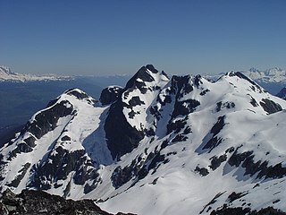
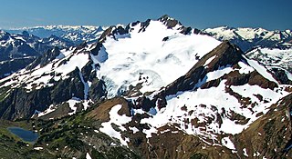
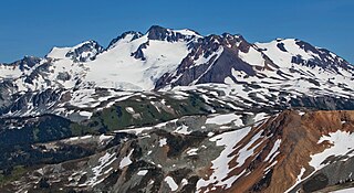
Mount Weart is a 2,835-metre (9,301-foot) triple-summit mountain located in the Garibaldi Ranges of the Coast Mountains, in northwestern Garibaldi Provincial Park of southwestern British Columbia, Canada. It is situated 14 km (9 mi) northeast of Whistler, and its nearest higher peak is Wedge Mountain, 3.7 km (2 mi) to the south, which is the only peak within the park higher than Weart. The Armchair Glacier rests below the west aspect of the summit, and the massive Weart Glacier spans the northern and eastern aspects of the mountain. Precipitation runoff from the peak and meltwater from the glaciers drains into Wedgemount Lake and tributaries of the Lillooet River.
Rethel Mountain is a 2,408-metre (7,900-foot) mountain summit located in the Garibaldi Ranges of the Coast Mountains, in northwestern Garibaldi Provincial Park of southwestern British Columbia, Canada. It is situated 11 km (7 mi) northeast of Whistler, on the south side of Wedgemount Lake and west side of Wedgemount Glacier. Its nearest higher peak is Parkhurst Mountain, 1.3 km (1 mi) to the southeast. Rethel is set 3.2 km (2 mi) northwest of Wedge Mountain, the highest peak in Garibaldi Park, and 2.9 km (2 mi) southwest of Mount Weart, the second-highest in the park. Precipitation runoff from the peak drains into Wedgemount Creek and Rethel Creek, both tributaries of the Green River, which in turn is a tributary of the Lillooet River. It was named in association from Rethel station on the Pacific Great Eastern Railway route. The mountain's name was officially adopted on February 27, 1978, by the Geographical Names Board of Canada.
Overlord Mountain is a 2,625-metre (8,612-foot) glacier-clad peak located in the Garibaldi Ranges of the Coast Mountains, in Garibaldi Provincial Park of southwestern British Columbia, Canada. It is the highest point of the Fitzsimmons Range, which is a subset of the Garibaldi Ranges, and can be readily seen from the Whistler Blackcomb ski area. It is situated 15 km (9 mi) southeast of Whistler, and its nearest higher peak is Mount Macbeth, 3 km (2 mi) to the north-northeast. The Benvolio Glacier rests below the south aspect of the summit, the Fitzsimmons Glacier on the east aspect, and the expansive Overlord Glacier spans the northern and western aspects of the mountain. Precipitation runoff from the peak and meltwater from its glaciers drains into tributaries of the Cheakamus River. The first ascent of the mountain was made in 1923 by Phyllis Munday and Don Munday via the Benvolio Glacier. The mountain's descriptive name was recommended by the Garibaldi Park Board and officially adopted on September 2, 1930, by the Geographical Names Board of Canada.
Mount Taylor is a 2,318-metre (7,605-foot) mountain summit located in the Coast Mountains, in Joffre Lakes Provincial Park, in southwestern British Columbia, Canada. It is part of the Joffre Group, which is a subset of the Lillooet Ranges. It is situated 21 km (13 mi) east of Pemberton, and 7 km (4 mi) northeast of Lillooet Lake. Its nearest higher peak is Slalok Mountain, 1.9 km (1 mi) to the east. Precipitation runoff from the peak drains into Joffre Creek, a tributary of the Lillooet River. The mountain's name was submitted by Karl Ricker of the Alpine Club of Canada to honor Ada C. Taylor, a Pemberton pioneer and the first nurse in that community. The toponym was officially adopted January 23, 1979, by the Geographical Names Board of Canada.

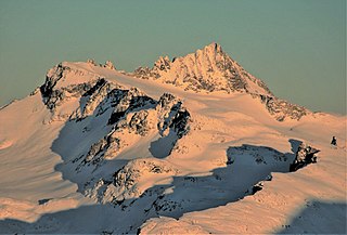
Tremor Mountain is a prominent 2,691-metre (8,829-foot) summit located in the Garibaldi Ranges of the Coast Mountains, in Garibaldi Provincial Park of southwestern British Columbia, Canada. It is the highest point of the Spearhead Range, which is a subset of the Garibaldi Ranges. It is situated 13 km (8 mi) southeast of Whistler, and 8.7 km (5 mi) south of Wedge Mountain, its nearest higher peak. Precipitation runoff from the south side of the peak as well as meltwater from the Platform Glacier drains into Fitzsimmons Creek which is a tributary of the Green River. Meltwater from the Tremor Glacier on the northwestern slope drains to Wedge Creek, and meltwater from the Shudder Glacier on the northeast slope drains into Billygoat Creek, a tributary of the Lillooet River. Tremor Mountain is often climbed as part of the Spearhead Traverse. The first ascent of the mountain was made in 1928 by A.J. Campbell Garibaldi survey party. The mountain's name origin refers to unexplained earth tremors when the first ascent party was on the summit. The mountain's toponym was officially adopted on September 6, 1951, by the Geographical Names Board of Canada.

Otter Mountain is a prominent 2,693-metre (8,835-foot) glaciated summit located in the Coast Mountains of British Columbia, Canada. It is situated 16 kilometers northeast of Stewart, British Columbia, and the nearest higher peak is Mount Pattullo, 25.4 km (15.8 mi) to the north. Otter ranks as the 23rd most topographically prominent summit of Canada. Topographic relief is significant as the summit rises 2,380 meters above Bitter Creek Valley in 5 kilometers. This mountain's toponym was adopted as "Mount Otter" on 24 July 1945, and officially renamed Otter Mountain on 5 November 1953 by the Geographical Names Board of Canada. Precipitation runoff from the mountain drains west into Bitter Creek which is a tributary of the Bear River, or east to Nelson Creek which is part of the Nass River drainage basin, and all ultimately finds its way to the Inside Passage.

Cathedral Mountain is a mountain summit located in British Columbia, Canada.

Mount Hanover is a mountain summit located in British Columbia, Canada.
Mount James Turner is a 2,703-metre (8,868-foot) mountain summit located in British Columbia, Canada.
Big Snow Mountain is a 2,357-metre (7,733-foot) mountain summit located in British Columbia, Canada.

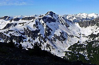
Stupendous Mountain is a 2,682-metre (8,799-foot) mountain summit located in British Columbia, Canada.