Pine Mountain (Grayson County, Virginia)

Last updated
Pine Mountain
2017-05-16 09 41 51 View south along the Appalachian Trail near the north end of the Wilburn Ridge Trail, looking towards Pine Mountain at the north end of Wilburn Ridge within the Mount Rogers National Recreation Area in Grayson County, Virginia.jpg
The mostly treeless summit of Pine Mountain
Highest point
Elevation 5,526 ft (1,684 m) [1]
Prominence 126 ft (38 m) [1]
Coordinates 36°39′26″N81°31′17″W / 36.657142°N 81.521274°W / 36.657142; -81.521274 [1]
Geography
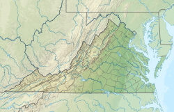
USA Virginia relief location map.svg
Red triangle with thick white border.svg
Pine Mountain
Virginia, U.S.
Location Mount Rogers National Recreation Area, Grayson County, Virginia, U.S.
Parent range Blue Ridge Mountains
Topo map White Top

Pine Mountain is a mountain in the Blue Ridge Mountains. It is located in the Mount Rogers National Recreation Area of the Jefferson National Forest, within Grayson County, Virginia, United States. [1] The peak is immediately east of the highest mountain of Virginia, Mount Rogers, and Pine Mountain's sparsely vegetated summit has excellent views of both Mount Rogers and the surrounding region. The Appalachian Trail passes within feet of the summit. [2] Pine Mountain is the second highest named summit in Virginia, though because its topographic prominence is well under 300 feet, it is considered a subsidiary peak of Mount Rogers.
Summit panorama

2017-05-16 09 55 12 Full 360-degree panorama from the summit of Pine Mountain within the Mount Rogers National Recreation Area in Grayson County, Virginia.jpg
360-degree panorama from the summit of Pine Mountain

Related Research Articles

<span class="mw-page-title-main">Appalachian Trail</span> Hiking trail going through fourteen US states

The Appalachian Trail, also called the A.T., is a hiking trail in the Eastern United States, extending almost 2,200 miles (3,540 km) between Springer Mountain in Georgia and Mount Katahdin in Maine, and passing through 14 states. The Appalachian Trail Conservancy claims the Appalachian Trail to be the world's longest hiking-only trail. More than three million people hike segments of it each year.

<span class="mw-page-title-main">Mount Umunhum</span> Mountain in California, United States

Mount Umunhum is a peak in the Santa Cruz Mountains, located in Santa Clara County, California. It is the fourth-highest peak in the Santa Cruz Mountains, after Loma Prieta, Crystal Peak, and Mt. Chual. Most of the mountain is located within the Sierra Azul Open Space Preserve.

<span class="mw-page-title-main">Mount Rogers</span> Highest point in Virginia, United States

Mount Rogers is the highest natural point in Virginia, United States, with a summit elevation of 5,729 feet (1,746 m) above mean sea level. The summit straddles the border of Grayson and Smyth Counties, Virginia, about 6.45 miles (10.38 km) WSW of Troutdale, Virginia. Most of the mountain is contained within the Lewis Fork Wilderness, while the entire area is part of the Mount Rogers National Recreation Area, which itself is a part of the Jefferson National Forest.

<span class="mw-page-title-main">Whitetop Mountain</span> Mountain in Virginia, United States

Whitetop Mountain is the second highest independent mountain in the U.S. state of Virginia, after nearby Mount Rogers. It is also the third highest named peak in Virginia, after Mount Rogers and its subsidiary peak, Pine Mountain. It is located at the juncture of Grayson, Smyth, and Washington Counties, and is also within the Mount Rogers National Recreation Area of the Jefferson National Forest. Whitetop was the location of the White Top Folk Festival from 1932 to 1939, with the exception of 1937. Like nearby Mount Rogers, it represents an ecological "island" of flora and fauna commonly found much farther north than Virginia, such as old growth red spruce and other northern softwoods.

<span class="mw-page-title-main">High Knob</span> Mountain in Virginia, United States of America

High Knob is the peak of Stone Mountain, that forms part of the border between Scott County and Wise County, Virginia, near the city of Norton that rises to 4,223 feet above mean sea level.

<span class="mw-page-title-main">Mount Lafayette</span> Mountain in New Hampshire, United States

Mount Lafayette is a 5,249-foot (1,600 m) mountain at the northern end of the Franconia Range in the White Mountains of New Hampshire, United States. It lies in the town of Franconia in Grafton County, and appears on the New England Fifty Finest list of the most topographically prominent peaks in New England. The mountain's upper reaches are located in the alpine zone, an area where only dwarf vegetation exists due to the harsh climate.

<span class="mw-page-title-main">Telescope Peak</span> Mountain in California, United States

Telescope Peak is the highest point within Death Valley National Park, in the U.S. state of California. It is also the highest point of the Panamint Range, and lies in Inyo County. From atop this desert mountain one can see for over one hundred miles in many directions, including west to Mount Whitney, and east to Charleston Peak. The mountain was named for the great distance visible from the summit.

<span class="mw-page-title-main">Black Mountains (North Carolina)</span> Mountain range in western North Carolina, US

The Black Mountains are a mountain range in western North Carolina, in the southeastern United States. They are part of the Blue Ridge Province of the Southern Appalachian Mountains. The Black Mountains are the highest mountains in the Eastern United States. The range takes its name from the dark appearance of the red spruce and Fraser fir trees that form a spruce-fir forest on the upper slopes which contrasts with the brown or lighter green appearance of the deciduous trees at lower elevations. The Eastern Continental Divide, which runs along the eastern Blue Ridge crest, intersects the southern tip of the Black Mountain range.

<span class="mw-page-title-main">Mount Kaweah</span> Highest mountain on the Kaweah Ridge

Mount Kaweah is a mountain in California's Sequoia National Park and forms part of the Kaweah Peaks Ridge, a spur of the Great Western Divide which extends south from Triple Divide Peak. It has a summit elevation of 13,807 ft (4,208 m), the highest along the Kaweah Peaks Ridge.

<span class="mw-page-title-main">Mount Rogers National Recreation Area</span>

Mount Rogers National Recreation Area is a United States national recreation area (NRA) in southwestern Virginia near the border with Tennessee and North Carolina. It centerpiece is the Lewis Fork Wilderness containing Mount Rogers, the highest point in the state of Virginia with a summit elevation of 5,729 feet. The recreation area is under the jurisdiction of the George Washington and Jefferson National Forests. The recreation area was established by an act of the United States Congress on May 31, 1966.

<span class="mw-page-title-main">South Mountain (Maryland and Pennsylvania)</span> Mountain in Maryland and Pennsylvania, United States

South Mountain is the northern extension of the Blue Ridge Mountain range into Maryland and Pennsylvania. From the Potomac River near Knoxville, Maryland in the south to Dillsburg, Pennsylvania in York County, Pennsylvania in the north, the 70-mile-long (110 km) range separates the Hagerstown and Cumberland valleys from the Piedmont regions of the two states.

The Appalachian National Scenic Trail spans 14 U.S. states over its roughly 2,200 miles (3,500 km): Georgia, North Carolina, Tennessee, Virginia, West Virginia, Maryland, Pennsylvania, New Jersey, New York, Connecticut, Massachusetts, Vermont, New Hampshire, and Maine. The southern end is at Springer Mountain, Georgia, and it follows the ridgeline of the Appalachian Mountains, crossing many of its highest peaks and running almost continuously through wilderness before reaching the northern end at Mount Katahdin, Maine.

<span class="mw-page-title-main">Cuyamaca Peak</span> Mountain in California, United States

Cuyamaca Peak is a mountain peak of the Cuyamaca Mountains range, in San Diego County, Southern California.

<span class="mw-page-title-main">Spruce Mountain (West Virginia)</span> Highest point in the state of West Virginia

Spruce Mountain, located in eastern West Virginia, is the highest ridge of the Allegheny Mountains. The whale-backed ridge extends for only 16 miles (26 km) from northeast to southwest, but several of its peaks exceed 4,500 feet (1,400 m) in elevation. The summit, Spruce Knob, is the highest Allegheny Mountain point both in the state and the entire range, which spans four states.

The Little Wilson Creek Wilderness is an area in the Mount Rogers National Recreation Area protected by the Eastern Wilderness Act of Congress to maintain its present, natural condition. As part of the wilderness system, it is intended to preserve a variety of natural life forms and contribute to a diversity of plant and animal gene pools. Over half of the ecosystems in the United States exist within designated wildernesses.

<span class="mw-page-title-main">Lewis Fork Wilderness</span>

The Lewis Fork Wilderness is an area in the Mount Rogers National Recreation Area protected by the Eastern Wilderness Act of Congress to maintain its present, natural condition. As part of the wilderness system, it is intended to preserve a variety of natural life forms and contribute to a diversity of plant and animal gene pools. Over half of the ecosystems in the United States exist within designated wilderness.

<span class="mw-page-title-main">Mountain peaks of Virginia</span>

This article comprises three sortable tables of the major mountain peaks of Virginia. This article defines a significant summit as a summit with at least 100 meters of topographic prominence, and a major summit as a summit with at least 500 meters of topographic prominence. All summits in this article have at least 500 meters of topographic prominence. An ultra-prominent summit is a summit with at least 1500 meters of topographic prominence.

References

  1. 1 2 3 4 "Pine Mountain, Virginia". Peakbagger.com. Retrieved 2017-09-26.
  2. "Pine Mountain/Wilburn Ridge". SummitPost.org. Retrieved 2017-09-26.