
The Appalachian Mountains, often called the Appalachians, are a system of mountains in eastern North America. The Appalachians first formed roughly 480 million years ago during the Ordovician Period. They once reached elevations similar to those of the Alps and the Rocky Mountains before experiencing natural erosion. The Appalachian chain is a barrier to east–west travel, as it forms a series of alternating ridgelines and valleys oriented in opposition to most highways and railroads running east–west.

Rockingham County is a county located in the U.S. state of Virginia. As of the 2010 census, the population was 76,314. Its county seat is the independent city of Harrisonburg.

The 252-mile (406 km) Tuscarora Trail is a long distance trail in the Ridge and Valley Appalachians that passes through the US states of Virginia, West Virginia, Maryland, and Pennsylvania. In the south, the Tuscarora begins at a junction with the Appalachian Trail (AT) near Mathews Arm Campground, 0.4-mile (0.64 km) south of the AT's crossing of Skyline Drive at MP 21.1 in Shenandoah National Park in Virginia. In the north, it rejoins the Appalachian Trail at the top of Blue Mountain just west of the Susquehanna River and Harrisburg, Pennsylvania, creating a 435 mi (700.1 km) circuit known as the Tuscalachian Loop. The Tuscarora Trail was built as an alternative parallel route for the Appalachian Trail. It was built farther west, in a more wild corridor, because it was feared that development would force closure of the AT, before passage of the National Scenic Trails Act of 1968.

The Hogarth Press was a British publishing house founded in 1917 by Leonard Woolf and Virginia Woolf. It was named after their house in Richmond, in which they began hand-printing books.

The Blue Ridge Mountains are a physiographic province of the larger Appalachian Mountains range. The mountain range is located in the eastern United States, and extends 550 miles southwest from southern Pennsylvania through Maryland, West Virginia, Virginia, North Carolina, South Carolina, Tennessee and Georgia. This province consists of northern and southern physiographic regions, which divide near the Roanoke River gap. To the west of the Blue Ridge, between it and the bulk of the Appalachians, lies the Great Appalachian Valley, bordered on the west by the Ridge and Valley province of the Appalachian range.
Springer Mountain is a mountain located in the Chattahoochee National Forest on the border of Fannin and Gilmer counties. Located in the Blue Ridge Mountains in northern Georgia, the mountain has an elevation of about 3,782 feet (1,153 m). Springer Mountain serves as the southern terminus for the Appalachian and Benton MacKaye trails.

Massanutten Mountain is a synclinal ridge in the Ridge-and-Valley Appalachians, located in the U.S. state of Virginia. It is near the West Virginia state line.

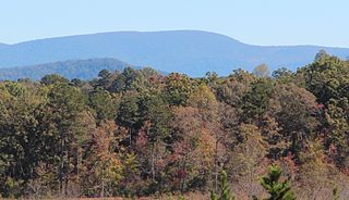
Mount Oglethorpe is a mountain located in Pickens County, Georgia, USA. The southernmost peak in the Blue Ridge Mountains, the mountain has an elevation of 3,288 feet (1,002 m), making it the highest point in Pickens County.

Wills Mountain is a quartzite-capped ridge in the Ridge and Valley physiographic province of the Appalachian Mountains in Pennsylvania and Maryland, United States, extending from near Bedford, Pennsylvania, to near Cumberland, Maryland. It is the northernmost of several mountain ridges included within the Wills Mountain Anticline.

Lake Winfield Scott is an 18-acre (7.3 ha) mountain lake located 10 miles (16 km) south of Blairsville, Georgia in Union County. The lake, which is owned and managed by the U.S. Forest Service, is the source of Cooper Creek. It is the centerpiece of the Forest Service's Lake Winfield Scott Recreation Area, a park which features hiking, fishing, boating and other outdoor activities. At 2,854 feet (870 m) elevation it is one of Georgia's highest altitude lakes. The various habitats surrounding the lake support a wide assortment of plants and animals.

Mountain Lake Wilderness is a U.S. Wilderness Area in the George Washington and Jefferson National Forests. The wilderness area is located next to privately owned Mountain Lake, and consists of 8,314 acres (3,365 ha) in Virginia and 2,721 acres (1,101 ha) in West Virginia.

Sherburne Pass, is a mountain pass in the Green Mountains of Vermont, between 3,957-foot (1,206 m) Pico Peak to the south and 2,782-foot (848 m) Deer Leap Mountain to the north. The height of land of the pass is located in the town of Killington, while its western ascent begins in the town of Mendon.
Chester Gap, sometimes referred to as Happy Creek Gap for the creek that runs down its western slope, is a wind gap in the Blue Ridge Mountains on the border of Rappahannock County, Fauquier County and Warren County in Virginia. The gap is traversed by U.S. Route 522. The Appalachian trail also passes across the gap, with a trailhead at the gap.
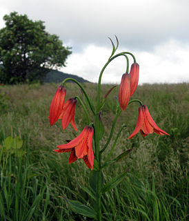
Lilium grayi is a perennial plant that is endemic to the eastern US states of North Carolina, Virginia, and Tennessee, growing in moist, acid soil in the Appalachian mountains on higher elevation meadows, bogs, and seeps. The plant was introduced to Royal Botanic Gardens, Kew in 1890 and was featured in the Kew Bulletin in 1892.
Bill Arp is an unincorporated community in Douglas County, Georgia, United States. The nearby communities are Winston and Douglasville.
The James River Gorge is a water gap created by the James River in Central Virginia. The Gorge is 2,433 feet (742 m) deep as measured from Highcock Knob 3,073 feet (937 m) to the James River 640 feet (200 m) and is approximately 9.3 miles (15.0 km) long. The James River forms in western Virginia near the border of West Virginia and initially flows south through the ridge and valley province of the Allegheny Mountains, turning northeast when it comes to the western edge of the Blue Ridge Mountains near Buchanan, Virginia. From Buchanan the river flows along the base of the Blue Ridge Mountains until it joins the Maury River near the town of Glasgow and then it turns southeast and begins its descent over the Balcony Falls rapids and through the James River Gorge. The rocks of the gorge are metamorphic in nature with the oldest exposed outcrops being from the Proterozoic Era. To the south of the river the peaks of the James River Face Wilderness dominate and to the north the peaks of Big Rocky Row and Little Rocky Row Mountains form a dramatic backdrop to the river far below. Multiple trails, including the Appalachian Trail go through the gorge and provide spectacular vistas of the scenery both at river level and from the peaks to the north and the south.
Stony Man Mountain, also known as Stony Man, is a mountain in Shenandoah National Park, Virginia and is the most northerly 4,000 foot peak in the Blue Ridge Mountains. Its maximum elevation is 4,011 feet or 1,223 meters above sea level with a clean prominence of 651 feet. The mountain is co-located in Madison and Page counties and is easily accessed from Skyline Drive by hiking trails. Along with Hawksbill Mountain, it is only one of two peaks in the park higher than 4,000 feet. The shortest route to the summit is from the Skyland Resort and gains less than 400 vertical feet in about 1 kilometer. A longer, more challenging, route is from the Skyline Drive trail head at about milepost 39 of the Skyline Drive and gains almost 800 feet. The peak sits just southeast of the Appalachian Trail (AT) but the summit is accessible from the AT by previously mentioned spur trails. On the upper slopes of Stony Man one can see a few red spruce and balsam fir trees which typically grow in more northerly latitudes. The mountain is composed of ancient basalt which was metamorphosed into Greenstone through heat and pressure.

Big Run is a river of 13 miles in length, located one-and-a-half miles west of Spruce Knob in Monongahela National Forest, in Pendleton County, West Virginia. It is a tributary of the North Fork South Branch Potomac River.
Chester Dziengielewski was the first person to successfully thru hike the Appalachian Trail from Maine to Georgia in 1951. Dziengielewski had attempted a southbound thru hike the previous year, but gave up the attempt at the Delaware Water Gap. He completed his hike on October 10, 1951, thereby becoming the third person to thru hike the Trail in any direction, after Earl Shaffer (1948) and Gene Espy (1951), who both hiked from Georgia to Maine.


