
Cumberland Gap is a town in Claiborne County, Tennessee, United States. Its population was 313 at the 2020 census, and estimated to be 315 in 2023. The town is located below the Cumberland Gap, a historic mountain pass for which is the town's namesake, and inside of the boundaries of Cumberland Gap National Historical Park.
Springer Mountain is a mountain located in the Chattahoochee National Forest on the border of Fannin and Gilmer counties. Located in the Blue Ridge Mountains in northern Georgia, the mountain has an elevation of about 3,770 feet (1,149 m). Springer Mountain serves as the southern terminus for the Appalachian and Benton MacKaye trails.

The Cumberland Mountains are a mountain range in the southeastern section of the Appalachian Mountains. They are located in western Virginia, southwestern West Virginia, the eastern edges of Kentucky, and eastern middle Tennessee, including the Crab Orchard Mountains. Their highest peak, with an elevation of 4,223 feet (1,287 m) above mean sea level, is High Knob, which is located near Norton, Virginia.

The Cumberland Gap National Historical Park is a United States National Historical Park located at the border between Kentucky, Tennessee, and Virginia, centered on the Cumberland Gap, a natural break in the Appalachian Mountains.

The Wilderness Road was one of two principal routes used by colonial and early national era settlers to reach Kentucky from the East. Although this road goes through the Cumberland Gap into southern Kentucky and northern Tennessee, the other is sometimes called the "Cumberland Road" because it started in Fort Cumberland in Maryland. Despite Kentucky Senator Henry Clay's advocacy of this route, early in the 19th century, the northern route was selected for the National Road, connecting near Washington, Pennsylvania into the Ohio Valley of northern Kentucky and Ohio.
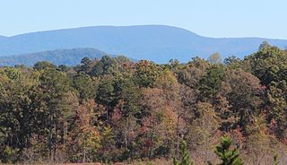
The Cumberland Gap is a pass in the eastern United States through the long ridge of the Cumberland Mountains, within the Appalachian Mountains and near the tripoint of Kentucky, Virginia, and Tennessee. At an elevation of 1,631 feet (497 m) above sea level, it is famous in American colonial history for its role as a key passageway through the lower central Appalachians.
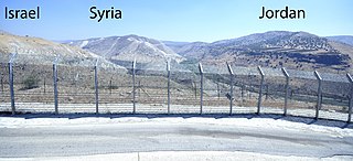
A triple border, tripoint, trijunction, triple point, or tri-border area is a geographical point at which the boundaries of three countries or subnational entities meet. There are 175 international tripoints as of 2020. Nearly half are situated in rivers, lakes or seas. On dry land, the exact tripoints may be indicated by markers or pillars, and occasionally by larger monuments.

Frozen Head State Park and Natural Area is a state park in Morgan County, Tennessee, in the southeastern United States. The park, situated in the Crab Orchard Mountains between the city of Wartburg and the community of Petros, contains some of the highest mountains in Tennessee west of the Blue Ridge Mountains.

Blood Mountain is the highest peak on the Georgia section of the Appalachian Trail and the sixth-tallest mountain in Georgia, with an elevation of 4,458 feet (1,359 m). It is located on the border of Lumpkin County with Union County and is within the boundaries of the Chattahoochee National Forest and the Blood Mountain Wilderness. There are several waterfalls, hiking trails and other recreational areas in the vicinity. This mountain marks the southernmost range limit for many Northern and Appalachian species, especially for plant species.

Hightower Bald, with an elevation of 4,568 feet (1,392 m) is the fourth-highest peak in the US state of Georgia. It is located in Towns County, Georgia at the North Carolina state line and is within the boundaries of the Southern Nantahala Wilderness of the Chattahoochee National Forest.

Black Mountain is located in Georgia USA on the boundary between Dawson and Gilmer counties. The summit is the highest point in Dawson County. It is in the Chattahoochee National Forest and is part of the Blue Ridge Wildlife Management Area.

Cove Lake State Park is a state park in Campbell County, Tennessee, in the southeastern United States. The park consists of 673 acres (2.72 km2) situated around Cove Lake, an impoundment of Cove Creek created by the completion of Caryville Dam in 1936. The park's location is in the town of Caryville and west of Jacksboro.

Brace Mountain is the peak of a ridge in the southern Taconic Mountains, near the tripoint of the U.S. states of New York, Connecticut and Massachusetts. Its 2,311-foot (704 m) main summit is located in New York; it is the highest point in that state's Dutchess County.

The Royal Colonial Boundary of 1665 marked the border between the Colony of Virginia and the Province of Carolina from the Atlantic Ocean westward across North America. The line follows the parallel 36°30′ north latitude that later became a boundary for several U.S. states as far west as the Oklahoma Panhandle, and also came to be associated with the Missouri Compromise of 1820.
The U.S. state of Tennessee is geographically diverse, with varying terrains and several distinct physiographic regions. Its landforms range from the Blue Ridge Mountains in the eastern part of the state to flat and fertile plains along the Mississippi River. The state is geographically, legally, culturally, and economically divided into three Grand Divisions: East Tennessee, Middle Tennessee, and West Tennessee.

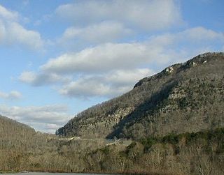
Pigeon Mountain is a summit in Walker County, Georgia. At its highest point, the mountain has an elevation of around 2,330 feet (710 m). Ellison's Cave and Petty John's Cave are both located on the mountain. Most of the mountain is located inside the Crockford-Pigeon Mountain Wildlife Management Area.

The North Carolina–Tennessee–Virginia Corners is a tripoint at which North Carolina, Tennessee and Virginia meet. The landmark is located in the Iron Mountains, and is roughly 16 miles (26 km) north of Snake Mountain, and 8 miles (13 km) southwest of Mount Rogers.

The Tri-States Monument is a granite monument that marks the tripoint of the state boundaries of New Jersey, New York, and Pennsylvania. It is at the northwestern end of the boundary between New Jersey and New York, the northern end of the boundary between New Jersey and Pennsylvania, and the eastern end of the boundary between New York and Pennsylvania. The monument is located at the confluence of the Delaware and Neversink rivers. This location is also known as Carpenter's Point.
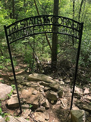
Tri-State Corner is the local name for the tripoint between the U.S. states of Tennessee, Georgia, and Alabama. The tripoint is located at the base of a mountain about 200 yards (180 m) south of Nickajack Lake, an impoundment of the Tennessee River. It is accessible from a nearby cemetery via a short trail.


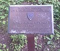 Royal Colonial Boundary of 1665 plaque
 Marker for Tennessee at Tri-State Peak
 Marker for the KY-TN-VA tripoint


