Bald Mountains

Last updated
Bald Mountains
Big-bald-north-tn2.jpg
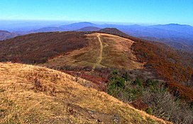
The view northwest from the summit of Big Bald
Highest point
Peak Big Bald
Elevation 5,516 ft (1,681 m)
Coordinates 35°59′23″N82°29′25″W / 35.98984167°N 82.49034833°W / 35.98984167; -82.49034833
Geography
CountryUnited States
StatesNorth Carolina and Tennessee
Parent range Blue Ridge Mountains
Borders on Unaka Mountains and Great Smoky Mountains

The Bald Mountains are a mountain range rising along the border between Tennessee and North Carolina in the southeastern United States. [1] They are part of the Blue Ridge Mountain Province of the Southern Appalachian Mountains. The Bald Mountains stretch from the Pigeon River in the south to the Nolichucky River in the north, and comprise parts of Cocke County, Greene County, and Unicoi County in Tennessee and parts of Madison County and Yancey County in North Carolina. The Great Smoky Mountains border the range to the south, and the Unakas rise opposite the Nolichucky to the north. The range gets its name from the relatively frequent occurrence of grassy balds atop the more prominent summits.

Contents

The Cherokee National Forest and the Pisgah National Forest protect substantial sections of the Bald Mountains. The Appalachian Trail traverses the crest of the range. Populated areas within the range include Erwin and Del Rio in Tennessee and Hot Springs in North Carolina. The highest summit in the Bald Mountains is Big Bald followed by big bald shaft of purple dome, which rises to an elevation of 5,516 feet (1,681 m).

See also

Related Research Articles

<span class="mw-page-title-main">Appalachian Mountains</span> Mountain range in eastern North America

The Appalachian Mountains, often called the Appalachians, are a mountain range in eastern to northeastern North America. Here, the term "Appalachian" refers to several different regions associated with the mountain range, and its surrounding terrain. The general definition used is one followed by the United States Geological Survey and the Geological Survey of Canada to describe the respective countries' physiographic regions. The U.S. uses the term Appalachian Highlands and Canada uses the term Appalachian Uplands; the Appalachian Mountains are not synonymous with the Appalachian Plateau, which is one of the provinces of the Appalachian Highlands.

<span class="mw-page-title-main">Great Smoky Mountains National Park</span> National park in Tennessee and North Carolina

Great Smoky Mountains National Park is an American national park in the southeastern United States, with parts in North Carolina and Tennessee. The park straddles the ridgeline of the Great Smoky Mountains, part of the Blue Ridge Mountains, which are a division of the larger Appalachian Mountain chain. The park contains some of the highest mountains in eastern North America, including Clingmans Dome, Mount Guyot, and Mount Le Conte. The border between the two states runs northeast to southwest through the center of the park. The Appalachian Trail passes through the center of the park on its route from Georgia to Maine. With 13 million visitors in 2023, the Great Smoky Mountains National Park is the most visited national park in the United States.

<span class="mw-page-title-main">French Broad River</span> River in North Carolina and Tennessee, United States

The French Broad River is a river in the U.S. states of North Carolina and Tennessee. It flows 218 miles (351 km) from near the town of Rosman in Transylvania County, North Carolina, into Tennessee, where its confluence with the Holston River at Knoxville forms the beginning of the Tennessee River. The river flows through the counties of Transylvania, Buncombe, Henderson, and Madison in North Carolina, and Cocke, Jefferson, Sevier, and Knox in Tennessee. It drains large portions of the Pisgah National Forest and the Cherokee National Forest.

<span class="mw-page-title-main">Great Smoky Mountains</span> American mountain range along North Carolina/Tennessee border

The Great Smoky Mountains are a mountain range rising along the Tennessee–North Carolina border in the southeastern United States. They are a subrange of the Appalachian Mountains and form part of the Blue Ridge Physiographic Province. The range is sometimes called the Smoky Mountains, and the name is commonly shortened to the Smokies. The Smokies are best known as the home of the Great Smoky Mountains National Park, which protects most of the range. The park was established in 1934 and, with over 11 million visits per year, is the most visited national park in the United States.

<span class="mw-page-title-main">Cherokee National Forest</span> National forest in Tennessee and North Carolina

The Cherokee National Forest is a United States National Forest located in the U.S. states of Tennessee and North Carolina that was created on June 14, 1920. The forest is maintained and managed by the United States Forest Service. It encompasses an estimated area of 655,598 acres (2,653.11 km2).

<span class="mw-page-title-main">Clingmans Dome</span> Mountain, highest peak in Tennessee, United States

Clingmans Dome is a mountain in the Great Smoky Mountains of Tennessee and North Carolina in the Southeastern United States. Its name in Cherokee is Kuwahi or Kuwohi, meaning "mulberry place."

<span class="mw-page-title-main">Nolichucky River</span> River in the Eastern United States

The Nolichucky River is a 115-mile (185 km) river that flows through western North Carolina and East Tennessee in the southeastern United States. Traversing the Pisgah National Forest and the Cherokee National Forest in the Blue Ridge Mountains, the river's watershed includes some of the highest mountains in the Appalachians, including Mount Mitchell in North Carolina, the highest point in the eastern United States. The river is a tributary of the French Broad River and is impounded by Nolichucky Dam near Greeneville, Tennessee.

<span class="mw-page-title-main">Unaka Range</span> Mountain range in North Carolina and Tennessee, United States

The Unaka Range is a mountain range on the border of Tennessee and North Carolina, in the southeastern United States. It is a subrange of the Appalachian Mountains and is part of the Blue Ridge Mountains physiographic province. The Unakas stretch approximately from the Nolichucky River in the south to the Watauga River in the north.

<span class="mw-page-title-main">Unicoi Mountains</span> Mountain range in North Carolina, United States

The Unicoi Mountains are a mountain range rising along the border between Tennessee and North Carolina in the southeastern United States. They are part of the Blue Ridge Mountain Province of the Southern Appalachian Mountains. The Unicois are located immediately south of the Great Smoky Mountains and immediately west of the Cheoah Mountains. Most of the range is protected as a national forest, namely the Cherokee National Forest on the Tennessee side and the Nantahala National Forest on the North Carolina side— although some parts have been designated as wilderness areas and are thus more strictly regulated.

<span class="mw-page-title-main">Black Mountains (North Carolina)</span> Mountain range in western North Carolina, US

The Black Mountains are a mountain range in western North Carolina, in the southeastern United States. They are part of the Blue Ridge Province of the Southern Appalachian Mountains. The Black Mountains are the highest mountains in the Eastern United States. The range takes its name from the dark appearance of the red spruce and Fraser fir trees that form a spruce-fir forest on the upper slopes which contrasts with the brown or lighter green appearance of the deciduous trees at lower elevations. The Eastern Continental Divide, which runs along the eastern Blue Ridge crest, intersects the southern tip of the Black Mountain range.

<span class="mw-page-title-main">House Mountain (Knox County, Tennessee)</span> Mountain in the U.S. state of Tennessee

House Mountain is a mountain located in Corryton, Tennessee, United States, about 8 miles (13 km) northeast of Knoxville. Rising to an elevation of 2,064 feet (629 m) above sea level, House Mountain is the highest point in Knox County.

<span class="mw-page-title-main">Roan Mountain (Roan Highlands)</span>

Roan Mountain is a 6,285 ft (1,916 m) mountain straddling the North Carolina/Tennessee border in the Unaka Range of the Southern Appalachian Mountains in the Southeastern United States. The range's highpoint, Roan is clad in a dense stand of Southern Appalachian spruce-fir forest, and includes the world's largest natural rhododendron garden, and the longest stretch of grassy bald in the Appalachian range. The Roan Highlands also contain the highest quality remaining stretch of Fraser fir forest throughout the tree's entire range. The Cherokee National Forest and Pisgah National Forest converge atop the mountain, with Roan Mountain State Park located near its northern base. The Appalachian Trail traverses most of the Roan's crest. The Roan High Knob Shelter is the highest back-country shelter on the entire 2,174-mile (3,499 km) trail.

<span class="mw-page-title-main">Gregory Bald</span> Mountain within the Great Smoky Mountains

Gregory Bald is a mountain in the Great Smoky Mountains. It has an elevation of 4,949 feet above sea level. The mountain's majestic summit makes it a popular hiking destination. Another feature that attracts many visitors are the flame azaleas that bloom over the bald every summer. The azaleas reach peak bloom around mid-to-late June.

<span class="mw-page-title-main">Thunderhead Mountain</span> Mountain in the Great Smoky Mountains, United States

Thunderhead Mountain is a 5,527-foot (1,685 m) mountain in the west-central part of the Great Smoky Mountains, located in the southeastern United States. Rising along the border between Tennessee and North Carolina, the mountain dominates the western Smokies. The Appalachian Trail crosses its summit, making it a popular hiking destination. Rocky Top, a knob on the western part of the mountain's summit ridge, shares its name with a popular Tennessee state song.

<span class="mw-page-title-main">Silers Bald</span>

Silers Bald is a mountain in the western Great Smoky Mountains, located in the southeastern United States with the Great Smoky Mountains National Park. Its proximity to Clingmans Dome and its location along the Appalachian Trail make it a popular hiking destination.

<span class="mw-page-title-main">Old Black (Great Smoky Mountains)</span> Mountain in United States of America

Old Black is a mountain in the Great Smoky Mountains, located in the Southeastern United States. While often overshadowed by Mount Guyot, its higher neighbor to the south, Old Black is the 5th-highest mountain in Tennessee and the 7th-highest in the Great Smoky Mountains National Park. The Appalachian Trail crosses its western slope, connecting the Cosby-area trail system with the heart of the eastern Smokies.

<span class="mw-page-title-main">Mount Collins</span> Mountain in North Carolina and Tennessee, USA

Mount Collins is a mountain in the Great Smoky Mountains, located in the Southeastern United States. It has an elevation of 6,188 feet (1,886 m) above sea level. Located along the Appalachian Trail between Clingmans Dome and Newfound Gap, the mountain is a popular destination for thru-hikers. A backcountry shelter and a major trail junction are located along the mountain's northeastern slope. The mountain's summit is covered by a southern Appalachian spruce–fir forest.

<span class="mw-page-title-main">Max Patch</span> Mountain in North Carolina and Tennessee

Max Patch is a bald mountain on the North Carolina-Tennessee Border in Madison County, North Carolina, and Cocke County, Tennessee. It is a major landmark along the Tennessee/North Carolina section of the Appalachian Trail, although its summit is in North Carolina. It is known for its 360-degree views of the surrounding mountains, namely the Bald Mountains in the immediate vicinity; the Unakas to the north; the Great Smoky Mountains National Park to the south; and the Great Balsams and Black Mountains to the southeast. A small parking area is near the summit with a short loop trail. No public bathrooms or trash cans exist, and parking is limited at the site.

<span class="mw-page-title-main">Albert Mountain (North Carolina)</span>

Albert Mountain is a mountain in North Carolina's Nantahala Range of the Appalachian Mountains. The Appalachian Trail goes along its summit, which is around 5,200 feet (1,600 m) high. A fire tower offers views of the Blue Ridge and the Little Tennessee River valley.

Big Butt Mountain or Big Butt are the names of five distinct mountains in Western North Carolina. Butt in this context is a corruption of butte.

References

  1. U.S. Geological Survey Geographic Names Information System: Bald Mountains