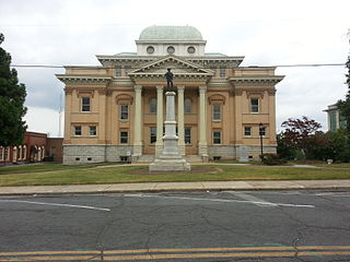
Randolph County is a county located in the U.S. state of North Carolina. As of the 2020 census, the population was 144,171. Its county seat is Asheboro.

Asheboro is a city in and the county seat of Randolph County, North Carolina, United States. The population was 27,156 at the 2020 census. It is part of the Greensboro-High Point Metropolitan Area of the Piedmont Triad and is home of the state-owned North Carolina Zoo.

Crowders Mountain State Park is a 5,217-acre (21.11 km2) North Carolina state park in Gaston County, North Carolina in the United States. It is near Kings Mountain, North Carolina and on the outskirts of Gastonia, North Carolina, it includes the peaks of Crowder's Mountain and The Pinnacle. Crowders Mountain is named for Crowders Creek which originates near its base. The cliffs are a popular destination for rock climbers.

The Uwharrie Mountains are a mountain range in North Carolina spanning the counties of Randolph, Montgomery, Stanly, and Davidson. The range's foothills stretch into Cabarrus, Anson, Union, and Richmond counties.

The Unicoi Mountains are a mountain range rising along the border between Tennessee and North Carolina in the southeastern United States. They are part of the Blue Ridge Mountain Province of the Southern Appalachian Mountains. The Unicois are located immediately south of the Great Smoky Mountains and immediately west of the Cheoah Mountains. Most of the range is protected as a national forest, namely the Cherokee National Forest on the Tennessee side and the Nantahala National Forest on the North Carolina side— although some parts have been designated as wilderness areas and are thus more strictly regulated.

The Foothills Parkway is a national parkway which traverses the foothills of the northern Great Smoky Mountains in East Tennessee, located in the southeastern United States. The 72.1-mile (114 km) parkway will connect U.S. Route 129 along the Little Tennessee River in the west with Interstate 40 (I-40) along the Pigeon River in the east.
The Old North State Council (ONSC) is a local council of the Boy Scouts of America that serves the eastern and southern portions of the Piedmont Triad region of North Carolina. The council is headquartered at the Royce Reynolds Family Scout Office in Greensboro, North Carolina and operates four camps; one of which is outside the council boundaries. The ONSC represents Boy Scouting in Davie, Davidson, Randolph, Guilford, Alamance, Rockingham, Caswell, and Person counties of North Carolina. The council's name is derived from the state's official song, The Old North State.
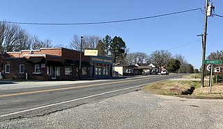
Bennett is a census-designated place in Chatham County, North Carolina, United States.
Cane Creek Mountains is a small mountain range that lies south of Burlington, North Carolina. The range covers an area including Alamance County, Guilford County, Randolph County, and Chatham County in North Carolina.
The South Mountains are an ancient and deeply eroded mountain range in western North Carolina. They are an isolated remnant of the much larger Appalachian Mountains to the west, and are separated from the Appalachians by the Catawba River valley. The range covers approximately 100,000 acres (400 km²) in Burke, Cleveland, McDowell and Rutherford counties. The South Mountains are the highest and most rugged chain of the isolated mountain ranges which dot North Carolina's Piedmont region. The highest point in the range is Icy knob which rises to 3,000 feet above sea level. The South Mountains are heavily forested with Southeastern mixed forests. Water erosion from numerous rivers and streams has given the mountains narrow ridges and valleys.

The Sinks of Gandy — also called the Sinks of Gandy Creek, or simply "The Sinks" — are a modestly celebrated cave and underground stream at Osceola in eastern Randolph County, West Virginia, United States. The Sinks are on private property within the Monongahela National Forest.
Greenwood Mountain is the name of several mountain summits in the United States.

U.S. Route 220 is a north–south U.S. highway which travels from Rockingham, North Carolina, to South Waverly, Pennsylvania. In the U.S. state of North Carolina, US 220 travels 123.4 miles (198.6 km) from an intersection with US 1 in Rockingham to the Virginia state line near Price, North Carolina. The highway is an important north–south route in Central North Carolina, connecting Rockingham, Asheboro, Greensboro, and Summerfield. US 220 runs concurrently with Interstate 73 from north of Rockingham to Greensboro, and from Summerfield to Stokesdale; while US 220 runs concurrently with I-74 from Rockingham to Randleman.
Mountain Lake Wilderness is a U.S. Wilderness Area in the George Washington and Jefferson National Forests. The wilderness area is located next to privately owned Mountain Lake, and consists of 8,314 acres (3,365 ha) in Virginia and 2,721 acres (1,101 ha) in West Virginia.
Ulah is an unincorporated community in Randolph County, North Carolina, United States. south of the neighboring county seat of Asheboro.
Black Ankle is an unincorporated community in the northeastern part of Montgomery County, North Carolina, United States.

The Maddron Bald Trail is an American hiking trail in the Great Smoky Mountains National Park of Cocke County, Tennessee. Rising from the outskirts of the Cosby community, the trail ascends Maddron Bald, a 5,212-foot (1,589 m) mountain crowned by one of the park's most substantial heath balds. The trail also provides access to Albright Grove, a patch of old growth hardwood forest that contains some of the oldest and tallest trees in the Smokies. The Maddron Bald Trail's terminus— at its junction with the Snake Den Ridge Trail— is just 0.7 miles (1.1 km) from the Appalachian Trail.

Marks Knob is a mountain in the central Great Smoky Mountains, in the southeastern United States. It has an elevation of 6,169 feet (1,880 m), with 249 feet (76 m) of clean prominence. Its summit is a popular bushwhacking destination and one of the most difficult-to-reach summits of the Southern Sixers.
Randolph Community College is a public community college in Asheboro, Randolph County, North Carolina. It is part of the North Carolina Community College System.
Taylors Creek is a 7.74 mi (12.46 km) long 3rd order tributary to Caraway Creek, in Randolph County, North Carolina.