Silers Bald

Last updated
Silers Bald
Silers-bald-from-narrows1.jpg
The summit of Silers Bald, looking west from the Narrows.
Highest point
Elevation 5,607 ft (1,709 m)
Prominence 337 ft (103 m)
Coordinates 35°33′57″N83°33′55″W / 35.56583°N 83.56528°W / 35.56583; -83.56528
Geography
Location Swain County, North Carolina / Sevier County, Tennessee, U.S.
Parent range Great Smoky Mountains
Topo map USGS Silers Bald
Climbing
Easiest route Appalachian Trail west from Clingmans Dome

Silers Bald is a mountain in the western Great Smoky Mountains, located in the southeastern United States with the Great Smoky Mountains National Park. Its proximity to Clingmans Dome and its location along the Appalachian Trail make it a popular hiking destination.

Contents

Description

Silers Bald is located on the crest of the Smokies with Thunderhead Mountain to the west and Clingmans Dome to the east. The Tennessee-North Carolina state line crosses the summit, with the mountain split evenly between Sevier County, Tennessee, to the north and Swain County, North Carolina, to the south. Silers Bald rises approximately 2,500 feet (760 m) above its northern base near Fish Camp Prong (of Little River), and approximately 3,000 feet (910 m) above its southern base near Forney Creek.

While Silers Bald was a grassy bald for most of the 19th and early 20th centuries, it was probably a wooded peak before the arrival of European settlers. For this reason, the National Park Service does not maintain the bald atop the mountain (the park currently maintains only two grassy balds Gregory Bald and Andrews Bald). [1] A narrow corridor for the Appalachian Trail, which crosses the summit, is kept clear for hikers. There is still a small bald area at the summit, approximately 30 feet (9.1 m) in diameter, where the Appalachian Trail makes a 90-degree turn. Several grassy meadows remain on the mountain's western slope.

Geology

Silers Bald consists of Thunderhead sandstone, a small pile of which crowns the summit. This sandstone, part of the Ocoee Supergroup, was formed from ocean sediments nearly a billion years ago. The mountain, like most of the Smokies, was formed some 200 million years ago when the North American and African plates collided during the Appalachian orogeny, pushing the rock upward. [2]

History

Clingman's Dome, looking east from the summit of Silers Bald Clingmans-dome-from-silers-bald.jpg
Clingman's Dome, looking east from the summit of Silers Bald

While Silers Bald is hardly mentioned in Cherokee lore, a petroglyph was discovered near the summit in 1917. [3] The mountain's elevation is probably recorded by Arnold Guyot during his 1859 survey of the Smokies crest but under a different name (possibly Guyot's "Big Stone Mountain," which Guyot listed with an elevation of 5,614 feet (1,711 m) and lying somewhere between Mt. Buckley and Thunderhead). [4]

What was once a massive grazing land has reverted to patches of meadow and young woodland on the western slope of Silers Bald Appalachian-trail-silers-bald-w1.jpg
What was once a massive grazing land has reverted to patches of meadow and young woodland on the western slope of Silers Bald

Silers Bald is named after Jesse Siler, a prominent North Carolinian who grazed sheep and cattle atop the mountain in the 19th century. Likewise, Siler Bald, in the Nantahala Mountains to the south, was named after Jesse's brother, William. Albert Mountain, also to the south, was named after Jesse's nephew, Albert Siler. [5]

By the late 19th century, Silers Bald was the far eastern end of a giant grassy pasture that stretched several miles across the Smokies' western ridge all the way to Russell Field, which overlooks Cades Cove. [6] The mountain is mentioned several times in Horace Kephart's Our Southern Highlanders as the last stop before one enters a heavily-wooded wilderness. [7] According to Kephart, beyond "Hall cabin" (a herder's shack near modern Big Chestnut Bald, six miles (10 km) east of Thunderhead):

...there is just one shack, at Siler's Meadow. It is down below the summit, hidden in timber, and you would never have seen it. Even if you had, you would have found it as bare as a last year's mouse nest, for nobody ever goes there except for a few bear-hunters. From there onward for forty miles is an uninhabited wilderness so rough that you could not make seven miles a day in it to save your life..." [8]

Laura Thornborough, a writer who visited Silers Bald in the 1930s, recalls it as a giant meadow:

Silers is one of the mysterious grassy balds, or mountain-top meadows, and an outstanding vantage point commanding spectacular views. [9]

Access

The summit of Silers Bald. The white arrows mark the direction of the Appalachian Trail Silers-bald-summit2.jpg
The summit of Silers Bald. The white arrows mark the direction of the Appalachian Trail

The easiest access to Silers Bald is to take the Clingmans Dome tower trail from the Forney Ridge parking lot to the tower. From there, following the Appalachian Trail west the summit of Silers Bald is just over four miles (6 km). This leg of the trail is riddled with elevation gain and loss, crossing Mt. Buckley (a knob of Clingmans Dome), Jenkins Knob, and a sparsely-wooded ridge known as "The Narrows".

At the summit of Silers Bald, an unmarked spur trail winds several yards to a cliff on the northwest slope of the mountain. This cliff offers a 180-degree view of the northern Smokies, with a clear view of Mount Le Conte to the east and Thunderhead Mountain to the west.

See also

Related Research Articles

<span class="mw-page-title-main">Clingmans Dome</span> Mountain, highest peak in Tennessee, United States

Clingmans Dome is a mountain in the Great Smoky Mountains of Tennessee and North Carolina in the Southeastern United States. Its name in Cherokee is Kuwahi or Kuwohi, meaning "mulberry place."

The Forney Ridge Trail is an American hiking trail, in the Great Smoky Mountains National Park of Swain County, North Carolina. The trail descends from just beneath the highest summit in the national park, Clingmans Dome, along Forney Ridge and passes through Andrews Bald before terminating at a junction with the Springhouse Branch Trail.

<span class="mw-page-title-main">Hiking in the Great Smoky Mountains National Park</span>

The Great Smoky Mountains National Park is a United States National Park located in a region of the Appalachian Mountains referred to as the Great Smoky Mountains, in a portion of east-central Tennessee and southwest North Carolina. With over 150 hiking trails extending for more than 850 miles (1,370 km), within its boundaries, including a seventy-mile segment of the Appalachian Trail, hiking is the most popular activity in the national park.

<span class="mw-page-title-main">Gregory Bald</span> Mountain within the Great Smoky Mountains

Gregory Bald is a mountain in the Great Smoky Mountains. It has an elevation of 4,949 feet above sea level. The mountain's majestic summit makes it a popular hiking destination. Another feature that attracts many visitors are the flame azaleas that bloom over the bald every summer. The azaleas reach peak bloom around mid-to-late June.

<span class="mw-page-title-main">Thunderhead Mountain</span> Mountain in the Great Smoky Mountains, United States

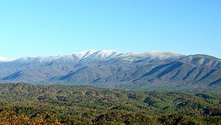
Thunderhead Mountain is a 5,527-foot (1,685 m) mountain in the west-central part of the Great Smoky Mountains, located in the southeastern United States. Rising along the border between Tennessee and North Carolina, the mountain dominates the western Smokies. The Appalachian Trail crosses its summit, making it a popular hiking destination. Rocky Top, a knob on the western part of the mountain's summit ridge, shares its name with a popular Tennessee state song.

<span class="mw-page-title-main">Mount Kephart</span> Mountain in United States of America

Mount Kephart is a mountain in the central Great Smoky Mountains, located in the Southeastern United States. The Appalachian Trail crosses the mountain's south slope, making it a destination for thru-hikers. The Jumpoff, a 1,000-foot (300 m) cliff on the northeast side of the mountain, has views of the central and eastern Smokies. A stand of Southern Appalachian spruce-fir forest coats the mountain's upper elevations.

<span class="mw-page-title-main">Old Black (Great Smoky Mountains)</span> Mountain in United States of America

Old Black is a mountain in the Great Smoky Mountains, located in the Southeastern United States. While often overshadowed by Mount Guyot, its higher neighbor to the south, Old Black is the 5th-highest mountain in Tennessee and the 7th-highest in the Great Smoky Mountains National Park. The Appalachian Trail crosses its western slope, connecting the Cosby-area trail system with the heart of the eastern Smokies.

<span class="mw-page-title-main">Mount Guyot (Great Smoky Mountains)</span>

Mount Guyot is a mountain in the Great Smoky Mountains, located in the southeastern United States. At 6,621 feet (2,018 m) in elevation, Guyot is the fourth-highest summit in the Eastern U.S., and the second-highest in the Great Smoky Mountains National Park. While the mountain is remote, the Appalachian Trail crosses its south slope, passing to within 1,000 feet (300 m) of the summit.

<span class="mw-page-title-main">Andrews Bald</span>

Andrews Bald is a mountain in the Great Smoky Mountains, located in the southeastern United States. It has an elevation of 5,920 feet (1,800 m) above sea level, making it the highest grassy bald in the Great Smoky Mountains National Park. The mountain is one of two grassy balds maintained in the range by the National Park Service. The other is Gregory Bald, in the western Smokies.

<span class="mw-page-title-main">Tricorner Knob</span>

Tricorner Knob is a mountain in the Great Smoky Mountains, located in the southeastern United States. It has an elevation of 6,120 feet, with 160 feet of clean prominence. The Appalachian and Balsam Mountain trails intersect near the mountain's summit, making Tricorner Knob the great crossroads of the eastern Smokies.

<span class="mw-page-title-main">Spence Field</span>

Spence Field is a mountain highland meadow in the Great Smoky Mountains, located in the Southeastern United States. It has an elevation of 4,920 feet above sea level. The Appalachian Trail traverses the field, and a backcountry shelter just off the trail provides an overnight stopover for through-hikers.

<span class="mw-page-title-main">Mount Collins</span> Mountain in North Carolina and Tennessee, USA

Mount Collins is a mountain in the Great Smoky Mountains, located in the Southeastern United States. It has an elevation of 6,188 feet (1,886 m) above sea level. Located along the Appalachian Trail between Clingmans Dome and Newfound Gap, the mountain is a popular destination for thru-hikers. A backcountry shelter and a major trail junction are located along the mountain's northeastern slope. The mountain's summit is covered by a southern Appalachian spruce–fir forest.

<span class="mw-page-title-main">Mount Chapman</span>

Mount Chapman is a mountain in the Great Smoky Mountains, located in the Southeastern United States. It has an elevation of 6,417 feet above sea level. While the mountain is located deep within the Smokies, the Appalachian Trail crosses its eastern slope, coming to within 200 feet (61 m) of the summit. Mount Chapman is among the 10 highest mountains in the Appalachian range, if subpeaks are not included.

<span class="mw-page-title-main">Charlies Bunion</span> Mountain in the eastern United States

Charlies Bunion is a mountain in the Great Smoky Mountains of the Southeastern United States, characterized by a large boulder-like protrusion just below the summit on its otherwise-sheer northern face. The mountain is a rare instance of a bare-rock summit in the Smokies.

<span class="mw-page-title-main">Hazel Creek (Great Smoky Mountains)</span> River in North Carolina, United States

Hazel Creek is a tributary stream of the Little Tennessee River in the southwestern Great Smoky Mountains of North Carolina. The creek's bottomlands were home to several pioneer Appalachian communities and logging towns before its incorporation into the Great Smoky Mountains National Park. Hazel Creek is now a back country campsite and historical area.

<span class="mw-page-title-main">Sugarland Mountain Trail</span>

The Sugarland Mountain Trail is an American hiking trail, in the Great Smoky Mountains National Park of Sevier County, Tennessee. The trail traverses Sugarland Mountain, a massive ridge running perpendicular to the main crest of the Smokies and effectively dividing the park's north-central section from its northwestern section. Sugarland Mountain is flanked by the deep upper valleys of two of the park's major watersheds— the West Fork of the Little Pigeon River and Little River. The trail passes through several forest types, including deciduous forest at lower elevations, heaths ("hells") along the mountain's backbone formations, and a stand of Southern Appalachian spruce-fir forest in the upper elevations. Occasional breaks in the foliage allow for views of Mount Le Conte and Sevier County to the east and Blanket Mountain and the ridges above Elkmont to the west.

<span class="mw-page-title-main">Snake Den Ridge Trail</span> Hiking trail in Tennessee, United States

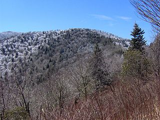
The Snake Den Ridge Trail is an American hiking trail in the Great Smoky Mountains National Park of Cocke County, Tennessee. Winding its way up the backbone-like crest of Snake Den Ridge, the trail connects the Cosby Campground to the Appalachian Trail and provides the quickest access to the high peaks of the Eastern Smokies. The trail passes through three forest types— a mixed deciduous forest at its lower elevations, a substantial stand of heath bald on the more narrow sections of the ridge crest, and an old growth northern-style coniferous forest at its higher elevations.

Our Southern Highlanders: A Narrative of Adventure in the Southern Appalachians and a Study of Life Among the Mountaineers is a book written by American author Horace Kephart (1862–1931), first published in 1913 and revised in 1922. Inspired by the years Kephart spent among the inhabitants of the remote Hazel Creek region of the Great Smoky Mountains, the book provides one of the earliest realistic portrayals of life in the rural Appalachian Mountains and one of the first serious analyses of Appalachian culture. While modern historians and writers have criticized Our Southern Highlanders for focusing too much on sensationalistic aspects of mountain culture, the book was an important departure from the previous century's local color writings and their negative distortions of mountain people.

References

  1. Daniel Pierce, The Great Smokies: From Natural Habitat to National Park (Knoxville: University of Tennessee Press, 2000), 178.
  2. Harry Moore, A Roadside Guide to the Geology of the Great Smoky Mountains National Park (Knoxville: University of Tennessee Press, 1988), 26-27.
  3. Robert Mason, The Lure of the Great Smokies (Boston and New York: Houghton-Mifflen, 1927), 44.
  4. Robert Mason, The Lure of the Great Smokies (Boston and New York: Houghton-Mifflen, 1927), 55-56.
  5. Larry Luxenberg, Walking the Appalachian Trail (Mechanicsburg, Penn: Stackpole Books, 1994), 25.
  6. Carson Brewer, Great Smoky Mountains National Park (Portland, Ore: Graphic Arts Center Publishing, 1993), 21.
  7. Horace Kephart, Our Southern Highlanders (Knoxville: University of Tennessee Press, 1976), 64, 214, e.g.
  8. Horace Kephart, Our Southern Highlanders (Knoxville: University of Tennessee Press, 1976), 64.
  9. Laura Thornborough, Great Smoky Mountains (Knoxville: University of Tennessee Press, 1942), 124.