
Gaston County is a county in the U.S. state of North Carolina. As of the 2020 census, the population was 227,943. The county seat is Gastonia. Dallas served as the original county seat from 1846 until 1911.
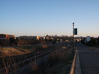
Kings Mountain is a small suburban city within the Charlotte metropolitan area in Cleveland and Gaston counties, North Carolina, United States. Most of the city is in Cleveland County, with a small eastern portion in Gaston County. The population was 10,296 at the 2010 census.

Mount Monadnock, or Grand Monadnock, is a mountain in the town of Jaffrey, New Hampshire. It is the most prominent mountain peak in southern New Hampshire and is the highest point in Cheshire County. It lies 38 miles (61 km) southwest of Concord and 62 miles (100 km) northwest of Boston. At 3,165 feet (965 m), Mount Monadnock is nearly 1,000 feet (305 m) higher than any other mountain peak within 30 miles (48 km) and rises 2,000 feet (610 m) above the surrounding landscape. Monadnock's bare, isolated, and rocky summit provides expansive views. It is known for being featured in the writings of Ralph Waldo Emerson and Henry David Thoreau.
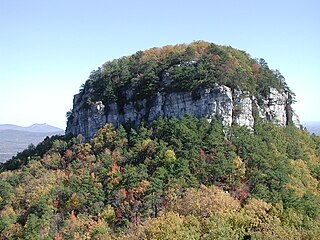
Pilot Mountain, a metamorphic quartzite monadnock rising to a peak 2,421 feet (738 m) above sea level, is one of the most distinctive natural features in the U.S. state of North Carolina. It is a remnant of the ancient chain of Sauratown Mountains. The Saura Native Americans, the region's earliest known inhabitants, called the mountain "Jomeokee", meaning "great guide".

The geography of North Carolina falls naturally into three divisions — the Appalachian Mountains in the west, the central Piedmont Plateau, and the eastern Atlantic Coastal Plain. North Carolina covers 53,819 square miles (139,391 km2) and is 503 miles (810 km) long by 150 miles (241 km) wide. The physical characteristics of the state vary from the summits of the Smoky Mountains, an altitude of near seven thousand feet (2,130 m) in the west, sloping eastward to sea level along the coast and beaches of the Atlantic Ocean.

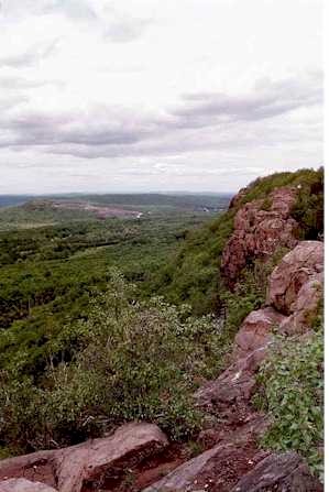
Crowders Mountain State Park is a 5,217-acre (21.11 km2) North Carolina state park in Gaston County, North Carolina in the United States. It is near Kings Mountain, North Carolina and on the outskirts of Gastonia, North Carolina, it includes the peaks of Crowder's Mountain and The Pinnacle. Crowders Mountain is named for Crowders Creek which originates near its base. The cliffs are a popular destination for rock climbers.

Hanging Rock State Park is a 9,011-acre (3,647 ha) North Carolina state park in Stokes County, North Carolina in the United States. The park is 30 miles (48 km) north of Winston-Salem and is located approximately 2 miles (3.2 km) from Danbury in Stokes County.

Pores Knob is a mountain peak located in Wilkes County, North Carolina, United States.
Crowders Mountain is one of two main peaks within Crowders Mountain State Park, the other peak being The Pinnacle. The park is located in the Western Piedmont of North Carolina between the cities of Kings Mountain and Gastonia or about 25 miles (40 km) west of Charlotte. Crowders Mountain abruptly rises nearly 800 feet (240 m) above the surrounding terrain, and has an elevation of 1,625 feet above sea level.

The Metacomet-Monadnock Trail is a 114-mile-long (183 km) hiking trail that traverses the Metacomet Ridge of the Pioneer Valley region of Massachusetts and the central uplands of Massachusetts and southern New Hampshire. Although less than 70 miles (110 km) from Boston and other large population centers, the trail is considered remarkably rural and scenic and includes many areas of unique ecologic, historic, and geologic interest. Notable features include waterfalls, dramatic cliff faces, exposed mountain summits, woodlands, swamps, lakes, river floodplain, farmland, significant historic sites, and the summits of Mount Monadnock, Mount Tom and Mount Holyoke. The Metacomet-Monadnock Trail is maintained largely through the efforts of the Western Massachusetts Chapter of the Appalachian Mountain Club (AMC). Much of the trail is a portion of the New England National Scenic Trail.

Mount Sunapee is a 5-mile-long (8.0 km) mountain ridge in the towns of Newbury and Goshen in western New Hampshire, United States. Its highest peak, at the north end of the mountain, is 2,726 feet (831 m) above sea level. The mountain has three secondary peaks, White Ledges at 2,716 ft (828 m); North Peak at 2,280 ft (695 m); and South Peak at 2,608 ft (795 m). The north end of the mountain, including the summit, is within Mount Sunapee State Park, which encompasses 3.85 square miles (10.0 km2) and is home to the popular Mount Sunapee Resort. The mountain extends south to Pillsbury State Park in the towns of Goshen and Washington.
Cane Creek Mountains is a small mountain range that lies south of Burlington, North Carolina. The range covers an area including Alamance County, Guilford County, Randolph County, and Chatham County in North Carolina.

The Monadnock-Sunapee Greenway (MSG) is a 50-mile (80 km) hiking trail that traverses the highlands of southern New Hampshire from Mount Monadnock in Jaffrey to Mount Sunapee in Newbury. Located approximately 27 miles (43 km) from the city of Concord, New Hampshire, the trail traverses a rural, heavily glaciated and metamorphic upland studded with lakes, heath barrens, the rocky summits of several monadnocks, and dense woodland of the northern hardwood forest type. The trail is maintained primarily through the efforts of the Monadnock-Sunapee Greenway Trail Club.
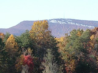
The Sauratown Mountains, which are sometimes called "the mountains away from the mountains", are an isolated mountain range located within Stokes and Surry counties in the U.S. state of North Carolina. The vast majority of the range is located in Stokes County. Although the range occupies only 5% of Stokes County's area, it dominates the county's scenery from almost every direction. The Sauras rise sharply 800 to 1,700 feet above the surrounding terrain.

Mount Norwottuck or Mount Norwottock, 1,106 feet (337 m) above sea level, is the highest peak of the Holyoke Range of traprock mountains located in the Connecticut River Valley of Massachusetts and part of the greater Metacomet Ridge which stretches from Long Island Sound to nearly the Vermont border. The peak rises steeply from the valley 1,000 feet (300 m) below and offers sweeping views of the surrounding countryside. It is located within the towns of Amherst and Granby, Massachusetts.

:Alternate spelling: should not be confused with Bear Mountain.

Pinnacle Rock, 600 feet (180 m), is a traprock mountain peak located 10 miles (16 km) southwest of Hartford, Connecticut, in the towns of Farmington and Plainville. It is part of the narrow, linear Metacomet Ridge that extends from Long Island Sound near New Haven, Connecticut, north through the Connecticut River Valley of Massachusetts to the Vermont border. Pinnacle Rock, popular as an outdoor recreation destination in the metropolitan Hartford area, is known for its clifftop scenic vistas, unique microclimate ecosystems, rare plant communities, and as a seasonal raptor migration path. Pinnacle Rock is traversed by the 51-mile (82 km) Metacomet Trail.
Higby Mountain or Mount Higby 892 feet (272 m), is a traprock mountain ridge located 3.75 miles (6.04 km) east of Meriden, Connecticut. It is part of the narrow, linear Metacomet Ridge that extends from Long Island Sound near New Haven, Connecticut, north through the Connecticut River Valley of Massachusetts to the Vermont border. Higby Mountain is known for its high cliff faces, unique microclimate ecosystems, and rare plant communities. It rises steeply 600 feet (180 m) above the Quinnipiac River valley and the city of Meriden to the west as a continuous 2-mile (3 km) long ledge. The mountain is traversed by the 50-mile (80 km) Mattabesett Trail.

Pack Monadnock or Pack Monadnock Mountain 2,290 feet (700 m), is the highest peak of the Wapack Range of mountains and the highest point in Hillsborough County, New Hampshire. The mountain, a monadnock, is located in south-central New Hampshire within the towns of Peterborough and Temple. The 22 mi (35 km) Wapack Trail and a number of shorter trails traverse the mountain. A firetower and ledges on the summit offer long views north to the White Mountains, west to Mount Monadnock, and south into Massachusetts. North Pack Monadnock Mountain is located directly to the north along the Wapack ridgeline; Temple Mountain to the south.
Long Mountain, 920 feet (280 m) feet above sea level, is a traprock mountain of the Holyoke Range, part of the greater Metacomet Ridge which stretches from Long Island Sound to nearly the Vermont border. The mountain rises steeply from the surrounding landscape 600 feet (180 m) below and consists of five distinct peaks, from east to west: 685 feet (209 m), 775 feet (236 m), 795 feet (242 m), 920 feet (280 m), the high point, and the eastern summit, 906 feet (276 m). It is located within the towns of Amherst and Granby, Massachusetts. The 110-mile (180 km) Metacomet-Monadnock Trail and the 47-mile (76 km) Robert Frost Trail traverse the mountain. The Holyoke Range continues to the west as Mount Norwottuck and to the east as Harris Mountain.

