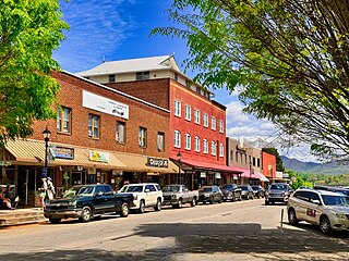
Franklin is a town in and the county seat of Macon County, North Carolina, United States. It is situated within the Nantahala National Forest. The population was reported to be 4,175 in the 2020 census, an increase from the total of 3,845 tabulated in 2010.

Brasstown Bald is the highest point in the U.S. state of Georgia. It is located in the northeastern part of the state in the Blue Ridge Mountains on the border between Towns and Union counties south of the city of Hiawassee. The mountain is known to the native Cherokee people as Enotah.

William Bartram was an American naturalist, writer and explorer. Bartram was the author of an acclaimed book, now known by the shortened title Bartram's Travels, which chronicled his explorations of the Southern Colonies of British North America from 1773 to 1777. Bartram has been described as "the first naturalist who penetrated the dense tropical forests of Florida".

Great Smoky Mountains National Park is a national park of the United States in the southeast, with parts in North Carolina and Tennessee. The park straddles the ridgeline of the Great Smoky Mountains, part of the Blue Ridge Mountains, which are a division of the larger Appalachian Mountain chain. The park contains some of the highest mountains in eastern North America, including Kuwohi, Mount Guyot, and Mount Le Conte. The border between the two states runs northeast to southwest through the center of the park. The Appalachian Trail passes through the center of the park on its route from Georgia to Maine. With 13 million visitors in 2023, the Great Smoky Mountains National Park is the most visited national park in the United States.

The Cherokee National Forest is a United States National Forest located in the U.S. states of Tennessee and North Carolina that was created on June 14, 1920. The forest is maintained and managed by the United States Forest Service. It encompasses an estimated area of 655,598 acres (2,653.11 km2).

Kuwohi is a mountain in the Great Smoky Mountains of Tennessee and North Carolina in the Southeastern United States.
The Unaka Range is a mountain range on the border of Tennessee and North Carolina, in the southeastern United States. It is a subrange of the Appalachian Mountains and is part of the Blue Ridge Mountains physiographic province. The Unakas stretch approximately from the Nolichucky River in the south to the Watauga River in the north.

The Unicoi Mountains are a mountain range rising along the border between Tennessee and North Carolina in the southeastern United States. They are part of the Blue Ridge Mountain Province of the Southern Appalachian Mountains. The Unicois are located immediately south of the Great Smoky Mountains and immediately west of the Cheoah Mountains. Most of the range is protected as a national forest, namely the Cherokee National Forest on the Tennessee side and the Nantahala National Forest on the North Carolina side— although some parts have been designated as wilderness areas and are thus more strictly regulated.

Mount Pisgah is a mountain in the Appalachian mountain range and part of the Blue Ridge Mountains of North Carolina, United States. The mountain's height is 5,721 feet above sea level, and it sits approximately 15 miles southwest of Asheville, near the crossing of the boundaries of Buncombe, Haywood, Henderson and Transylvania counties. It is located on the border of Buncombe and Haywood counties, close to the point where Henderson and Transylvania meet them, but not actually within the latter two counties. The mountain is easily accessible via a hiking trail from the Blue Ridge Parkway, near the Pisgah Inn.
The Bartram Trail follows the approximate route of 18th-century naturalist William Bartram’s southern journey from March 1773 to January 1777. Bartram explored much of the territory which is now the states of North and South Carolina, Georgia, Florida, Alabama, Mississippi, Louisiana and Tennessee.
The Nantahala National Forest is the largest of the four national forests in North Carolina, lying in the mountains and valleys of western North Carolina. The Nantahala is the second wettest region in the country, after the Pacific Northwest. Due to its environmental importance and historical ties with the Cherokee, the forest was officially established on January 29, 1920, by President Woodrow Wilson. The word "Nantahala" is a Cherokee derived word, meaning "Land of the Noonday Sun." In some spots, the sun reaches the floors of the deep gorges of the forest only when it is high overhead at midday. This was part of the homeland of the historic Cherokee and their indigenous ancestors, who have occupied the region for thousands of years. The Nantahala River runs through it.

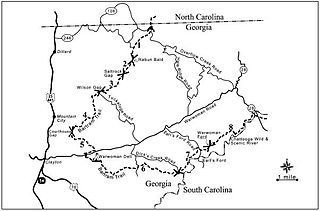
Rabun Bald, with an elevation of 4,696 feet (1,431 m), is the second-highest peak in the U.S. state of Georgia; only Brasstown Bald 4,784 feet (1,458 m) is higher. It is immediately southeast of Sky Valley, Georgia, and is the tallest mountain in the county. An observation tower on the summit provides hikers with views that, on clear days, extend for more than 100 miles (160 km). The hike to the top of Rabun Bald is 5.8 miles (9.3 km) round trip via the Rabun Bald Trail. The Rabun Bald Trail connects with the Bartram Trail system, which passes over the top as it winds through northeast Georgia for 37 miles (60 km).

Devil's Courthouse is a mountain in the Appalachian Mountains of western North Carolina in the United States of America. The mountain is located at the Western edge of the Pisgah National Forest about 10 miles northwest of Brevard and 28 miles southwest of Asheville. Located at milepost 422.4 of the Blue Ridge Parkway, the Devil's Courthouse has a moderate/strenuous trail climbing a half mile to its peak where panoramic views can be seen.

Roan Mountain is a 6,277 ft (1,913 m) mountain straddling the North Carolina/Tennessee border in the Unaka Range of the Southern Appalachian Mountains in the Southeastern United States. The range's highpoint, Roan is clad in a dense stand of Southern Appalachian spruce-fir forest, and includes the world's largest natural rhododendron garden, and the longest stretch of grassy bald in the Appalachian range. The Roan Highlands also contain the highest quality remaining stretch of Fraser fir forest throughout the tree's entire range. The Cherokee National Forest and Pisgah National Forest converge atop the mountain, with Roan Mountain State Park located near its northern base. The Appalachian Trail traverses most of the Roan's crest. The Roan High Knob Shelter is the highest back-country shelter on the entire 2,174-mile (3,499 km) trail.

Gregory Bald is a mountain in the Great Smoky Mountains. It has an elevation of 4,949 feet above sea level. The mountain's majestic summit makes it a popular hiking destination. Another feature that attracts many visitors are the flame azaleas that bloom over the bald every summer. The azaleas reach peak bloom around mid-to-late June.

Shuckstack is a mountain in the Great Smoky Mountains of Swain County, North Carolina, in the southeastern United States. It has an elevation of 4,020 feet (1,230 m) above sea level and rises approximately 2,300 feet (700 m) above Fontana Lake to the south.

Wesser Bald is a summit located in Macon County, North Carolina, near the community of Wesser. A wooden fire tower at the summit provides hikers with unimpeded views of the Great Smoky Mountains National Park and also the Nantahala Mountains. The Appalachian Trail traverses the summit from roughly north to south with the Nantahala Outdoor Center lying to the north within the Nantahala Gorge and Tellico gap just to the south. Tellico gap has unimproved road access. The climb from Tellico Gap takes an average of 20 minutes. Also, a third route, the blue trail, departs from the end of Wesser Creek Road and follows Wesser Creek up to a point just south of the summit to a fork with the Appalachian Trail. The summit is located at 4,627 ft (1,410 m). and is within Nantahala National Forest. A map detailing the highway routes to access Tellico Gap is available at the Nantahala Outdoor Center. Observable landforms include Wayah Bald, the Nantahala Gorge, and Kuwohi among others. The Wesser Fire Tower provides 360 degree views of the Smokies in a short 1.5 mile hike from Tellico Gap on the Appalachian Trail, with an elevation gain of about 767 feet. The Fire Tower was originally reported as destroyed during the forest fires which ravaged the Nantahala Forest in November, 2016 but it was later learned that it survived.

Max Patch is a bald mountain on the North Carolina-Tennessee Border in Madison County, North Carolina, and Cocke County, Tennessee. It is a major landmark along the Tennessee/North Carolina section of the Appalachian Trail, although its summit is in North Carolina. It is known for its 360-degree views of the surrounding mountains, namely the Bald Mountains in the immediate vicinity; the Unakas to the north; the Great Smoky Mountains National Park to the south; and the Great Balsams and Black Mountains to the southeast. A small parking area is near the summit with a short loop trail. No public bathrooms or trash cans exist, and parking is limited at the site.

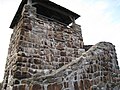
Albert Mountain is a mountain in North Carolina's Nantahala National Forest of the Appalachian Mountains. The Appalachian Trail goes along its summit, which is around 5,200 feet (1,600 m) high. A fire tower offers views of the Blue Ridge and the Little Tennessee River valley.

Nantahala Township is located in North Carolina, United States in the part of Macon County which is west of Wayah Gap. It has a population of 1,711.