Buncombe County

Big Butt Mountain or Big Butt are the names of five distinct mountains in Western North Carolina. Butt in this context is a corruption of butte. [1]

The Unaka Range is a mountain range on the border of Tennessee and North Carolina, in the southeastern United States. It is a subrange of the Appalachian Mountains and is part of the Blue Ridge Mountains physiographic province. The Unakas stretch approximately from the Nolichucky River in the south to the Watauga River in the north.
Powell Mountain is a mountain ridge of the Ridge-and-valley Appalachians of the Appalachian Mountains. It is a long and narrow ridge, running northeast to southwest, from about Norton, Virginia, to near Tazewell, Tennessee. It separates the Clinch River basin and the Powell River basin of Powell Valley. It was named for an 18th-century explorer.

Roan Mountain is a 6,277 ft (1,913 m) mountain straddling the North Carolina/Tennessee border in the Unaka Range of the Southern Appalachian Mountains in the Southeastern United States. The range's highpoint, Roan is clad in a dense stand of Southern Appalachian spruce-fir forest, and includes the world's largest natural rhododendron garden, and the longest stretch of grassy bald in the Appalachian range. The Roan Highlands also contain the highest quality remaining stretch of Fraser fir forest throughout the tree's entire range. The Cherokee National Forest and Pisgah National Forest converge atop the mountain, with Roan Mountain State Park located near its northern base. The Appalachian Trail traverses most of the Roan's crest. The Roan High Knob Shelter is the highest back-country shelter on the entire 2,174-mile (3,499 km) trail.

Waterrock Knob is a mountain peak in the U.S. state of North Carolina. It is the highest peak in the Plott Balsams and is the 16th-highest mountain in the Eastern United States.
Jupiter is an unincorporated community in northwestern Buncombe County, North Carolina, United States, located off U.S. Highway 25/70, and Interstate 26. It was disincorporated in 1970. It lies at an elevation of 2,175 feet (663 m).

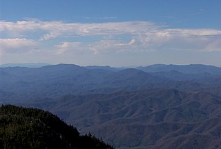
The Bald Mountains are a mountain range rising along the border between Tennessee and North Carolina in the southeastern United States. They are part of the Blue Ridge Mountain Province of the Southern Appalachian Mountains. The Bald Mountains stretch from the Pigeon River in the south to the Nolichucky River in the north, and comprise parts of Cocke County, Greene County, and Unicoi County in Tennessee and parts of Madison County and Yancey County in North Carolina. The Great Smoky Mountains border the range to the south, and the Unakas rise opposite the Nolichucky to the north. The range gets its name from the relatively frequent occurrence of grassy balds atop the more prominent summits.
Richland Balsam is a mountain in the Great Balsam Mountains in the U.S. state of North Carolina. Rising to an elevation of 6,410 feet (1,950 m), it is the highest mountain in the Great Balsam range, is among the 20 highest summits in the Appalachian range, and is the ninth highest peak in the Eastern United States. The Blue Ridge Parkway reaches an elevation of 6,053 feet (1,845 m)—the parkway's highest point—as it passes over Richland Balsam's southwestern slope. The Jackson County-Haywood County line crosses the mountain's summit.

Albert Mountain is a mountain in North Carolina's Nantahala National Forest of the Appalachian Mountains. The Appalachian Trail goes along its summit, which is around 5,200 feet (1,600 m) high. A fire tower offers views of the Blue Ridge and the Little Tennessee River valley.

The Temescal Mountains, also known as the Sierra Temescal, are one of the northernmost mountain ranges of the Peninsular Ranges in western Riverside County, in Southern California in the United States. They extend for approximately 25 mi (40 km) southeast of the Santa Ana River east of the Elsinore Fault Zone to the Temecula Basin and form the western edge of the Perris Block.
Forks of Ivy is an unincorporated community primarily located in Buncombe County, North Carolina, United States. A portion of Forks of Ivy extends into Madison County as it is situated on the county line on Ivy Creek. Forks of Ivy is named for the fact that it is near the junction of Ivy and Little Ivy Creeks.
Old Butt Knob is a summit in Haywood County, North Carolina, in the United States. It is located within Pisgah National Forest. With an elevation of 5,522 feet (1,683 m), Old Butt Knob is the 114th highest mountain in North Carolina.
Coon Butt is a summit in Blount County, Tennessee, in the United States. It is located within the Great Smoky Mountains National Park. With an elevation of 2,326 feet (709 m), Coon Butt is the 422nd highest mountain of Tennessee.
McAlpine Mountain is a summit in Henderson County, North Carolina, in the United States. With an elevation of 2,923 feet (891 m), McAlpine Mountain is the 1673th highest summit in the state of North Carolina.
Grindstone Butte is a summit in Haakon County, South Dakota, in the United States. With an elevation of 2,595 feet (791 m), Grindstone Butte is the 417th highest summit in the state of South Dakota.
Lanfair Buttes, also known as Eagle Mountain, Indian Hill, Eagle Hill, Graveyard Hills is a summit in the Mojave National Preserve in the Mojave Desert in San Bernardino County, California. The Lanfair Buttes lie 3 miles (4.8 km) east-southeast of the Grotto Hills and 8 miles (13 km) north-northeast of Hackberry Mountain in Lanfair Valley. The tallest and northernmost elevation in the Lanfair Buttes is Eagle Mountain at 1338 feet. The southernmost elevation is Indian Hill, at 35°08′36.71″N115°09′15.34″W at an elevation of 1281 feet. Indian Well, an old well is found west of the Buttes at 35°08′43″N115°09′32″W, and petroglyphs are found nearby on the slope of the Buttes to the east. Indian Well petroglyphs indicate it was a Native American water source and camping site in previous centuries. Indian Well was also located along the route of the Mohave Trail.
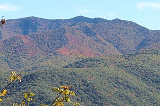
Big Bald is a mountain on the border of Yancey County, North Carolina and Unicoi County, Tennessee. located along the Appalachian Trail. at an elevation of 5,516 feet (1,681 m), it is the highest peak in the Bald Mountains, which are part of the larger Blue Ridge Mountains subrange of the Appalachian Mountains.