
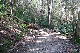
The Appalachian Trail, also called the A.T., is a hiking trail in the Eastern United States, extending almost 2,200 miles (3,540 km) between Springer Mountain in Georgia and Mount Katahdin in Maine, and passing through 14 states. The Appalachian Trail Conservancy claims the Appalachian Trail to be the world's longest hiking-only trail. More than three million people hike segments of it each year.

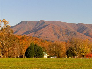
Great Smoky Mountains National Park is a national park of the United States in the southeast, with parts in North Carolina and Tennessee. The park straddles the ridgeline of the Great Smoky Mountains, part of the Blue Ridge Mountains, which are a division of the larger Appalachian Mountain chain. The park contains some of the highest mountains in eastern North America, including Clingmans Dome, Mount Guyot, and Mount Le Conte. The border between the two states runs northeast to southwest through the center of the park. The Appalachian Trail passes through the center of the park on its route from Georgia to Maine. With 13 million visitors in 2023, the Great Smoky Mountains National Park is the most visited national park in the United States.

The Unicoi Mountains are a mountain range rising along the border between Tennessee and North Carolina in the southeastern United States. They are part of the Blue Ridge Mountain Province of the Southern Appalachian Mountains. The Unicois are located immediately south of the Great Smoky Mountains and immediately west of the Cheoah Mountains. Most of the range is protected as a national forest, namely the Cherokee National Forest on the Tennessee side and the Nantahala National Forest on the North Carolina side— although some parts have been designated as wilderness areas and are thus more strictly regulated.

The Cherohala Skyway is a 43-mile (69 km) National Scenic Byway and National Forest Scenic Byway that connects Tellico Plains, Tennessee, to Robbinsville, North Carolina, in the southeastern United States. Its name is a portmanteau of Cherokee and Nantahala, the two national forests through which it passes. Along with multiple vistas and overlooks, the skyway provides easy vehicular access to various protected and recreational areas of the Unicoi Mountains, including the Citico Creek Wilderness, the Bald River Gorge Wilderness, and the remote interior of the Joyce Kilmer Memorial Forest.

Pisgah National Forest is a National Forest in the Appalachian Mountains of western North Carolina. It is administered by the United States Forest Service, part of the United States Department of Agriculture. The Pisgah National Forest is completely contained within the state of North Carolina. The forest is managed together with the other three North Carolina National Forests from common headquarters in Asheville, North Carolina. There are local ranger district offices located in Pisgah Forest, Mars Hill, and Nebo.
The Benton MacKaye Trail or BMT is a footpath nearly 300 miles (480 km) in length in the Appalachian Mountains in the southeastern United States and is blazed by a white diamond, 5″ across by 7″ tall. The hiking trail was created and is maintained by the Benton MacKaye Trail Association, and it is named for Benton MacKaye, the Massachusetts forester and regional planner who first had the idea for the Appalachian Trail in 1921.

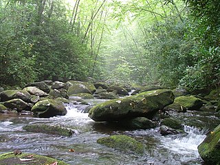
The Great Smoky Mountains National Park is a United States National Park located in a region of the Appalachian Mountains referred to as the Great Smoky Mountains, in a portion of east-central Tennessee and southwest North Carolina. With over 150 hiking trails extending for more than 850 miles (1,370 km), within its boundaries, including a seventy-mile segment of the Appalachian Trail, hiking is the most popular activity in the national park.
The Nantahala National Forest is the largest of the four national forests in North Carolina, lying in the mountains and valleys of western North Carolina. The Nantahala is the second wettest region in the country, after the Pacific Northwest. Due to its environmental importance and historical ties with the Cherokee, the forest was officially established on January 29, 1920, by President Woodrow Wilson. The word "Nantahala" is a Cherokee derived word, meaning "Land of the Noonday Sun." In some spots, the sun reaches the floors of the deep gorges of the forest only when it is high overhead at midday. This was part of the homeland of the historic Cherokee and their indigenous ancestors, who have occupied the region for thousands of years. The Nantahala River runs through it.
The Appalachian National Scenic Trail spans 14 U.S. states over its roughly 2,200 miles (3,500 km): Georgia, North Carolina, Tennessee, Virginia, West Virginia, Maryland, Pennsylvania, New Jersey, New York, Connecticut, Massachusetts, Vermont, New Hampshire, and Maine. The southern end is at Springer Mountain, Georgia, and it follows the ridgeline of the Appalachian Mountains, crossing many of its highest peaks and running almost continuously through wilderness before reaching the northern end at Mount Katahdin, Maine.

Gregory Bald is a mountain in the Great Smoky Mountains. It has an elevation of 4,949 feet above sea level. The mountain's majestic summit makes it a popular hiking destination. Another feature that attracts many visitors are the flame azaleas that bloom over the bald every summer. The azaleas reach peak bloom around mid-to-late June.
Mount Cammerer is a mountain on the northeastern fringe of the Great Smoky Mountains, in the southeastern United States. The mountain is situated on the state line between Cocke County, Tennessee, and Haywood County, North Carolina. The Appalachian Trail traverses Cammerer's south slope, and a restored fire lookout at the summit offers panoramic views of the eastern Smokies, Cocke County, and the Blue Ridge Mountains.

Silers Bald is a mountain in the western Great Smoky Mountains, located in the southeastern United States with the Great Smoky Mountains National Park. Its proximity to Clingmans Dome and its location along the Appalachian Trail make it a popular hiking destination.

Shuckstack is a mountain in the Great Smoky Mountains of Swain County, North Carolina, in the southeastern United States. It has an elevation of 4,020 feet (1,230 m) above sea level and rises approximately 2,300 feet (700 m) above Fontana Lake to the south.

The Sugarland Mountain Trail is an American hiking trail, in the Great Smoky Mountains National Park of Sevier County, Tennessee. The trail traverses Sugarland Mountain, a massive ridge running perpendicular to the main crest of the Smokies and effectively dividing the park's north-central section from its northwestern section. Sugarland Mountain is flanked by the deep upper valleys of two of the park's major watersheds— the West Fork of the Little Pigeon River and Little River. The trail passes through several forest types, including deciduous forest at lower elevations, heaths ("hells") along the mountain's backbone formations, and a stand of Southern Appalachian spruce-fir forest in the upper elevations. Occasional breaks in the foliage allow for views of Mount Le Conte and Sevier County to the east and Blanket Mountain and the ridges above Elkmont to the west.
Citico Creek Wilderness is a 16,226-acre (66 km2) wilderness area within the Cherokee National Forest in the U.S. state of Tennessee. The wilderness contains the entire upper drainage of Citico Creek, which consists of the north and south forks and at least eight tributaries. Three steep-sided ridges descend west from the crest of the Unicoi Mountains — Brush Mountain, Pine Ridge, and Sassafras Ridge.

The Snake Den Ridge Trail is an American hiking trail in the Great Smoky Mountains National Park of Cocke County, Tennessee. Winding its way up the backbone-like crest of Snake Den Ridge, the trail connects the Cosby Campground to the Appalachian Trail and provides the quickest access to the high peaks of the Eastern Smokies. The trail passes through three forest types— a mixed deciduous forest at its lower elevations, a substantial stand of heath bald on the more narrow sections of the ridge crest, and an old growth northern-style coniferous forest at its higher elevations.

The Maddron Bald Trail is an American hiking trail in the Great Smoky Mountains National Park of Cocke County, Tennessee. Rising from the outskirts of the Cosby community, the trail ascends Maddron Bald, a 5,212-foot (1,589 m) mountain crowned by one of the park's most substantial heath balds. The trail also provides access to Albright Grove, a patch of old growth hardwood forest that contains some of the oldest and tallest trees in the Smokies. The Maddron Bald Trail's terminus— at its junction with the Snake Den Ridge Trail— is just 0.7 miles (1.1 km) from the Appalachian Trail.

Mount Sterling is a mountain in the Great Smoky Mountains of Haywood County, North Carolina and Cocke County, Tennessee, located in the southeastern United States. It reaches an elevation of 5,842 feet (1,781 m) above sea level. The summit is topped by an abandoned fire tower that overlooks other nearby peaks.

Albert Mountain is a mountain in North Carolina's Nantahala Range of the Appalachian Mountains. The Appalachian Trail goes along its summit, which is around 5,200 feet (1,600 m) high. A fire tower offers views of the Blue Ridge and the Little Tennessee River valley.

Nantahala Township is located in North Carolina, United States in the part of Macon County which is west of Wayah Gap. It has a population of 1,711.
