Tomkins Knob

Last updated
Tomkins Mountain
USA North Carolina relief location map.jpg
Red triangle with thick white border.svg
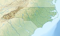
Tomkins Mountain
Location in North Carolina
Usa edcp relief location map.png
Red triangle with thick white border.svg
Tomkins Mountain
Tomkins Mountain (the US)
Highest point
Elevation 4,075 ft (1,242 m) [1]
Coordinates 36°14′26″N81°28′38″W / 36.24056°N 81.47722°W / 36.24056; -81.47722 Coordinates: 36°14′26″N81°28′38″W / 36.24056°N 81.47722°W / 36.24056; -81.47722 [1]
Geography
Location Ashe / Watauga / Wilkes counties, North Carolina, U.S.
Parent range Blue Ridge Mountains
Topo map USGS Maple Springs

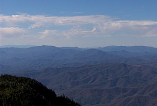
Tomkins Mountain (variant names: Thomkins Knob, Thompkins Knob and Tompkins Knob) is a mountain in the North Carolina High Country, near the community of Deep Gap. The majority of the mountain is within the Blue Ridge Parkway. Its elevation reaches 4,075 feet (1,242 m) and it also marks the corner between Ashe, Watauga, and Wilkes counties.

North Carolina State of the United States of America

North Carolina is a state in the southeastern region of the United States. It borders South Carolina and Georgia to the south, Tennessee to the west, Virginia to the north, and the Atlantic Ocean to the east. North Carolina is the 28th-most extensive and the 9th-most populous of the U.S. states. The state is divided into 100 counties. The capital is Raleigh, which along with Durham and Chapel Hill is home to the largest research park in the United States. The most populous municipality is Charlotte, which is the second-largest banking center in the United States after New York City.

Western North Carolina

Western North Carolina is the region of North Carolina which includes the Appalachian Mountains, thus it is often known geographically as the state's Mountain Region. It contains the highest mountains in the Eastern United States. Western North Carolina is sometimes included with upstate South Carolina as the "Western Carolinas", which is also counted as a single media market. The region covers an area of about 11,000 square miles (28,000 km2), and is roughly the size of the state of Massachusetts. The population of the region, as measured by the 2010 U.S. Census, is 1,473,241, which is approximately 15% of North Carolina's total population.

Deep Gap, North Carolina Unincorporated community in North Carolina, United States

Deep Gap is an unincorporated community located in Watauga County, North Carolina, United States. The community is named after the natural gap, called Deep Gap, at Fire Scale Mountain, where the Blue Ridge Parkway crosses over US 421. Influential guitar player Doc Watson was born in Deep Gap and lived there until his death May 29, 2012.

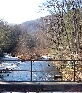
Split along the Eastern Continental Divide, it generates feeder streams to both the South Fork New River (via West Fork Pine Swamp Creek [2] ) and Yadkin River (via South Prong Lewis Fork [3] ). Laurel Spur Ridge [4] juts out south from the mountain; while Husons Ridge [5] goes northwest, marking the Ashe/Watauga county line.

Eastern Continental Divide Hydrological divide in eastern North America

The Eastern Continental Divide or Eastern Divide or Appalachian Divide is a hydrographic divide in eastern North America that separates the easterly Atlantic Seaboard watershed from the westerly Gulf of Mexico watershed. The divide nearly spans the United States from south of Lake Ontario through the Florida peninsula, and consists of raised terrain including the Appalachian Mountains to the north, the southern Piedmont Plateau and lowland ridges in the Atlantic Coastal Plain to the south. Water including rainfall and snowfall, lakes, streams and rivers on the eastern/southern side of the divide drains to the Atlantic Ocean; water on the western/northern side of the divide drains to the Gulf of Mexico. The ECD is one of six continental hydrographic divides of North America which define several drainage basins, each of which drains to a particular body of water.

South Fork New River river in the United States of America

The South Fork New River is a river in the U.S. state of North Carolina.

Yadkin River river in the United States of America

The Yadkin River is one of the longest rivers in North Carolina, flowing 215 miles (346 km). It rises in the northwestern portion of the state near the Blue Ridge Parkway's Thunder Hill Overlook. Several parts of the river are impounded by dams for water, power, and flood control. The river becomes the Pee Dee River at the confluence of the Uwharrie River south of the community of Badin, NC and east of the town of Albemarle, NC. The river flows into South Carolina near Cheraw, which is at the Fall Line. The entirety of the Yadkin River and the Great Pee Dee River is part of the Yadkin-Pee Dee River Basin.

Related Research Articles

Holston River river in the United States of America

The Holston River is a 136-mile (219 km) river that flows from Kingsport, Tennessee, to Knoxville, Tennessee. Along with its three major forks, it comprises a major river system that drains much of northeastern Tennessee, southwestern Virginia, and northwestern North Carolina. The Holston's confluence with the French Broad River at Knoxville marks the beginning of the Tennessee River.

Thurston Island Antarctic island

Thurston Island is an ice-covered, glacially dissected island, 215 km (134 mi) long, 90 km (56 mi) wide and 15,700 km2 (6,062 sq mi) in area, lying a short way off the northwest end of Ellsworth Land, Antarctica. It is the third largest island of Antarctica, after Alexander Island and Berkner Island.

Unaka Range mountain in United States of America

The Unaka Range is a mountain range on the border of Tennessee and North Carolina, in the southeastern United States. It is a subrange of the Appalachian Mountains and is part of the Blue Ridge Mountains physiographic province. The Unakas stretch approximately from the Nolichucky River to the south to the Watauga River to the north. The Unakas include the prominent Roan Highlands, where several summits rise above 6,000 feet. The Iron Mountains border the Unakas to the north, and the Bald Mountains border the Unakas opposite the Nolichucky to the south. The name unaka is rooted in the Cherokee term unega, meaning "white".

Patterson Creek Mountain mountain in United States of America

Patterson Creek Mountain is a mountain ridge that forms the border between Mineral and Hampshire counties and Grant and Hardy Counties in West Virginia's Eastern Panhandle. The mountain's namesake, Patterson Creek, parallels its western flank. The southern end of the Patterson Creek Mountain is near the confluence of Lunice Creek and the South Branch Potomac River and its northern end is located southwest of Springfield. The mountain reaches its highest elevation at Charles Knob.

Shavers Fork Mountain Complex

Shavers Fork Mountain Complex is the name given to the mountains on either side of Shavers Fork in the highlands portions of Randolph County, Pocahontas County, and Tucker County in West Virginia, USA. Much of the land surrounding the river and its adjacent mountains is protected by Monongahela National Forest including about 20,000 acres (81 km2) of designated wilderness.

Waterrock Knob mountain in United States of America

Waterrock Knob is a mountain peak in the U.S. state of North Carolina. It is the highest peak in the Plott Balsams and is the 16th-highest mountain in the Eastern United States.

Great Craggy Mountains

The Great Craggy Mountains, commonly called the Craggies, are a mountain range in western North Carolina, United States. They are a subrange of the Blue Ridge Mountains and encompass an area of approx. 194 sq mi (503 km²). They are situated in Buncombe County, North Carolina, 14 miles northeast of Asheville. The Black Mountains lie to the northeast, across the upper Cane River valley.

Glady Fork river in the United States of America

Glady Fork is a 31.9-mile-long (51.3 km) river in the Allegheny Mountains of eastern West Virginia, USA. It is considered one of the five principal headwaters tributaries of the Cheat River — known as the Forks of Cheat.

Foscoe, North Carolina Unincorporated community in North Carolina, United States

Foscoe is an unincorporated community and census-designated place in Watauga County, North Carolina, United States. The community is located on NC 105, southwest of Boone.

South Toe River river in the United States of America

The South Toe River is a river in Mitchell, Yancey and McDowell counties in Western North Carolina. The name Toe is taken from its original name Estatoe, pronounced 'S - ta - toe', a native American name associated with the Estatoe trade route leading down from the NC mountains through Brevard where there is a historical plaque with information that affirms the route, on into South Carolina where a village of the same name was located.

Aho, North Carolina Unincorporated community in North Carolina, United States

Aho is an unincorporated community located in Watauga County, North Carolina, United States. Possibly named after the Aho Branch that flows nearby, the community is located along the Blue Ridge Parkway at Bentley Knob, northeast of Blowing Rock.

Fire Scale Mountain mountain in United States of America

Fire Scale Mountain is a mountain in the North Carolina High Country, near the community of Deep Gap. The majority of the mountain is within the Blue Ridge Parkway. Its elevation reaches 3,845 feet (1,172 m).

Crossing Knob mountain in United States of America

Crossing Knob is a mountain in the North Carolina High Country, west from the community of Sugar Grove. The mountain is within the Pisgah National Forest and its elevation reaches 3,340 feet (1,018 m). The mountain is flanked by the Watauga River on three sides and US 321 along its south.

Snake Mountain (North Carolina – Tennessee) mountain in United States of America

Snake Mountain is a mountain located along the border between North Carolina and Tennessee, east of the community of Zionville, in the southeastern United States. It is part of the Blue Ridge Mountains, and includes parts of Watauga County, North Carolina, and Johnson County, Tennessee. It has two peaks, the highest of which reaches an elevation of 5,564 feet (1,696 m). The lower peak, at 5,518 feet (1,682 m), is Johnson County's high point.

Elk Knob (Watauga County, North Carolina) mountain in United States of America

Elk Knob is a mountain in the North Carolina High Country, north of the community of Meat Camp. Its elevation reaches 5,538 feet (1,688 m).

Howard Knob mountain in United States of America

Howard Knob is a mountain in the North Carolina High Country, located in the town of Boone. According to the US Geological Survey, the mountain's proper name is Howard Knob, but it is known to locals and tourists as Howard's Knob. Howard Knob and the surrounding area are part of the Appalachian Mountain Range. The mountain has an elevation of 4,396 feet (1,340 m) above sea level, and rises nearly 1,000 feet (300 m) above the town of Boone and the campus of Appalachian State University.

Rich Mountain Bald (Watauga County, North Carolina) mountain in United States of America

Rich Mountain Bald is a mountain in the North Carolina High Country, southeast of the community of Zionville. Its elevation reaches 5,361 feet (1,634 m).

Rich Mountain (Watauga County, North Carolina) mountain in United States of America

Rich Mountain is a mountain located in the North Carolina High Country, northwest of the town of Boone. Its elevation reaches 4,741 feet (1,445 m).

References