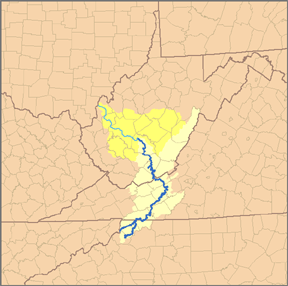
Watauga County is a county located in the U.S. state of North Carolina. As of the 2020 Census, the population was 54,086. Its county seat and largest town is Boone. The county is in an exceptionally mountainous region. It is the home of Appalachian State University, which has approximately 20,023 students as of August 20, 2020. Watauga County comprises the Boone, NC Micropolitan Statistical Area.
Ashe County is a county located in the U.S. state of North Carolina. As of the 2020 census, the population was 26,577. Its county seat is Jefferson.

Alleghany County is a county located in the U.S. state of North Carolina. As of the 2020 Census, the population was 10,888. Its county seat is Sparta.

The French Broad River is a river in the U.S. states of North Carolina and Tennessee. It flows 218 miles (351 km) from near the town of Rosman in Transylvania County, North Carolina, into Tennessee, where its confluence with the Holston River at Knoxville forms the beginning of the Tennessee River. The river flows through the counties of Transylvania, Buncombe, Henderson, and Madison in North Carolina, and Cocke, Jefferson, Sevier, and Knox in Tennessee. It drains large portions of the Pisgah National Forest and the Cherokee National Forest.

The Shenandoah River is the principal tributary of the Potomac River, 55.6 miles (89.5 km) long with two forks approximately 100 miles (160 km) long each, in the U.S. states of Virginia and West Virginia. The river and its tributaries drain the central and lower Shenandoah Valley and the Page Valley in the Appalachians on the west side of the Blue Ridge Mountains, in northwestern Virginia and the Eastern Panhandle of West Virginia. There is a hydroelectric plant along the Shenandoah river constructed in 2014 by Dominion.

The Feather River is the principal tributary of the Sacramento River, in the Sacramento Valley of Northern California. The river's main stem is about 73 miles (117 km) long. Its length to its most distant headwater tributary is just over 210 miles (340 km). The main stem Feather River begins in Lake Oroville, where its four long tributary forks join—the South Fork, Middle Fork, North Fork, and West Branch Feather Rivers. These and other tributaries drain part of the northern Sierra Nevada, and the extreme southern Cascades, as well as a small portion of the Sacramento Valley. The total drainage basin is about 6,200 square miles (16,000 km2), with approximately 3,604 square miles (9,330 km2) above Lake Oroville.

The Chattooga River is the main tributary of the Tugaloo River.

The South Branch Potomac River has its headwaters in northwestern Highland County, Virginia near Hightown along the eastern edge of the Allegheny Front. After a river distance of 139 miles (224 km), the mouth of the South Branch lies east of Green Spring in Hampshire County, West Virginia where it meets the North Branch Potomac River to form the Potomac.
Sleepy Creek is a 44.0-mile-long (70.8 km) tributary of the Potomac River in the United States, belonging to the Chesapeake Bay's watershed. The stream rises in Frederick County, Virginia, and flows through Morgan County, West Virginia before joining the Potomac near the community of Sleepy Creek.
The Pacolet River is a tributary of the Broad River, about 50 miles (80 km) long, in northwestern South Carolina in the United States. One of its principal headwaters tributaries also drains a small portion of western North Carolina. Via the Broad and Congaree rivers, it is part of the watershed of the Santee River, which flows to the Atlantic Ocean. The stream's name has also been spelled historically as "Pacolate River".
The Mitchell River is a tributary of the Yadkin River in northwestern North Carolina in the United States. Via the Yadkin it is part of the watershed of the Pee Dee River, which flows to the Atlantic Ocean. According to the Geographic Names Information System, it has also been known historically as "Mitchells River," "Mitchels River," and "Mountain Creek."

Western North Carolina is the region of North Carolina which includes the Appalachian Mountains; it is often known geographically as the state's Mountain Region. It contains the highest mountains in the Eastern United States, with 125 peaks rising to over 5,000 feet in elevation. Mount Mitchell at 6,684 feet, is the highest peak of the Appalachian Mountains and mainland eastern North America. Western North Carolina is sometimes included with upstate South Carolina as the "Western Carolinas", which is counted as a single media market. The population of the region, as measured by the 2010 U.S. Census, is 1,473,241, which is approximately 15% of North Carolina's total population.
The Soque River and its watershed are located entirely within the county boundaries of Habersham County in northeast Georgia. The Soque is a tributary of the Chattahoochee River. Portions of the river run along State Route 197.
The South Toe River is a river in Yancey County in Western North Carolina. The name Toe is taken from its original name Estatoe, pronounced 'S - ta - toe', a native American name associated with the Estatoe trade route leading down from the NC mountains through Brevard where there is a historical plaque with information that affirms the route, on into South Carolina where a village of the same name was located.
Tomkins Mountain is a mountain in the North Carolina High Country, near the community of Deep Gap. The majority of the mountain is within the Blue Ridge Parkway. Its elevation reaches 4,075 feet (1,242 m) and it also marks the corner between Ashe, Watauga, and Wilkes counties.

Snake Mountain is a mountain located along the border between North Carolina and Tennessee, east of the community of Zionville, in the southeastern United States. It is part of the Blue Ridge Mountains, and includes parts of Watauga County, North Carolina, and Johnson County, Tennessee. It has two peaks, the highest of which reaches an elevation of 5,564 feet (1,696 m). The lower peak, at 5,518 feet (1,682 m), is Johnson County's high point.
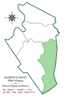
Washington District, formerly Washington Magisterial District, is one of five historic magisterial districts in Jackson County, West Virginia, United States. The district was originally established as one of five civil townships in Jackson County after West Virginia became a state in 1863; in 1872, all of West Virginia's townships were converted into magisterial districts. When Jackson County was redistricted in the 1990s, Washington District was combined with the eastern portion of Ripley District, including the city of Ripley, to form the new Eastern Magisterial District. However, the county's historic magisterial districts continue to exist in the form of tax districts, serving all of their former administrative functions except for the election of county officials.

The Eastern Magisterial District is one of three magisterial districts in Jackson County, West Virginia, United States. It was established during a process of redistricting undertaken in the 1990s. In 2010, 9,882 people lived in the district.