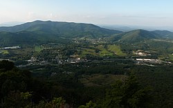
Jefferson, North Carolina | |
|---|---|
 Town hall | |
Logo | |
 Location within the U.S. state of North Carolina | |
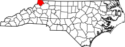
 Location within Ashe County | |
| Coordinates: 36°25′15″N81°28′06″W / 36.42083°N 81.46833°W | |
| Country | |
| State | |
| County | Ashe |
| Founded | as Jeffersonton (1799) as Jefferson (1799) |
| Named after | Thomas Jefferson |
| Government | |
| • Mayor | Peter Eller (I) |
| Area | |
• Total | 2.12 sq mi (5.48 km2) |
| • Land | 2.11 sq mi (5.47 km2) |
| • Water | 0.0039 sq mi (0.01 km2) |
| Elevation | 2,907 ft (886 m) |
| Population (2020) | |
• Total | 1,622 |
| • Density | 767.5/sq mi (296.33/km2) |
| Time zone | UTC−5 (Eastern) |
| • Summer (DST) | UTC−4 (EDT) |
| ZIP Code | 28640 |
| Area codes | 336, 743 |
| FIPS code | 37-34440 [3] |
| GNIS feature ID | 2405910 [2] |
| Website | www |
Jefferson is a town in and the county seat of Ashe County, North Carolina, United States. [4] At the 2020 census, the population was 1,622. [5]