Lansing, North Carolina | |
|---|---|
 Aerial Photo of Lansing | |
 Seal | |
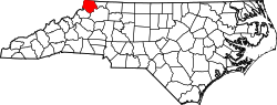
 Location of Lansing, North Carolina | |
| Coordinates: 36°29′57″N81°30′38″W / 36.49917°N 81.51056°W | |
| Country | |
| State | |
| County | Ashe |
| Area | |
• Total | 0.38 sq mi (0.98 km2) |
| • Land | 0.37 sq mi (0.96 km2) |
| • Water | 0.0077 sq mi (0.02 km2) |
| Elevation | 2,654 ft (809 m) |
| Population | |
• Total | 126 |
• Estimate (2023) | 222 |
| • Density | 340.9/sq mi (131.63/km2) |
| Time zone | UTC-5 (Eastern (EST)) |
| • Summer (DST) | UTC-4 (EDT) |
| ZIP code | 28643 |
| Area codes | 336, 743 |
| FIPS code | 37-36960 [4] |
| GNIS feature ID | 2405986 [2] |
| Website | www |
Lansing is a resort town in Ashe County, North Carolina, United States. The population was 126 at the 2020 census. [3]
Contents
Lansing is a popular destination among retirees and tourists from Florida, as well as those from the lower elevations of the Carolinas and Georgia.