Beaver Creek, Ashe County, North Carolina

Last updated

Beaver Creek
USA North Carolina location map.svg
Red pog.svg
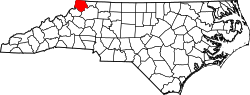
Location of Beaver Creek within North Carolina
Coordinates: 36°22′41″N81°29′53″W / 36.37806°N 81.49806°W / 36.37806; -81.49806
Country Flag of the United States.svg United States
State North Carolina
County Ashe
Elevation
[1]
3,041 ft (927 m)
Time zone UTC-5 (EST)
  Summer (DST) UTC-4 (EDT)
ZIP code
28694 [2]
Area code(s) 336, 743
FIPS code 37-37009
GNIS feature ID1019027 [1]

Beaver Creek is an unincorporated community in Ashe County, North Carolina, United States.

Contents

History

The Virginia–Carolina Railway once had service through this area. The Virginia–Carolina Railway was an interstate railroad in southwestern Virginia and northwestern North Carolina. It ran from Abingdon in Washington County, Virginia to Todd in Ashe County. The line charted a complicated course through the mountains of the area, crossing the Blue Ridge near Mount Rogers.

Geography

Beaver Creek is located in south-central Ashe County, south of West Jefferson. The elevation of Beaver Creek is 3,041 feet (927 m).

Transportation

US 221 and NC 194 are the primary routes within Beaver Creek.

References

  1. 1 2 U.S. Geological Survey Geographic Names Information System: Beaver Creek, North Carolina. Retrieved on 2008-04-16.
  2. "Beaver Creek North NC". ZIP Code Lookup. Archived from the original on June 15, 2011. Retrieved June 9, 2008.