Shelby, North Carolina | |
---|---|
City | |
Coordinates: 35°17′25″N81°32′43″W / 35.29028°N 81.54528°W | |
Country | United States |
State | North Carolina |
County | Cleveland |
Named for | Isaac Shelby |
Area | |
• Total | 22.39 sq mi (57.98 km2) |
• Land | 22.35 sq mi (57.90 km2) |
• Water | 0.03 sq mi (0.09 km2) |
Elevation | 873 ft (266 m) |
Population (2020) | |
• Total | 21,918 |
• Estimate (2022) [3] | 21,855 |
• Density | 980.50/sq mi (378.57/km2) |
Time zone | UTC−5 (Eastern (EST)) |
• Summer (DST) | UTC−4 (EDT) |
ZIP codes | 28150-28152 |
Area code | 704, 980 |
FIPS code | 37-61200 [4] |
GNIS feature ID | 2405454 [2] |
Website | cityofshelby.com |
Shelby is a city in and the county seat of Cleveland County, North Carolina. [5] It lies near the western edge of the Charlotte-Concord, NC-SC Combined Statistical Area. The population was 21,918 at the 2020 census.
The area was originally inhabited by Catawba and Cherokee peoples and was later settled around 1760. The city was chartered in 1843 and named after Colonel Isaac Shelby, a hero of the battle of Kings Mountain (1780) during the American Revolution. Shelby was agricultural until the railways in the 1870s stimulated Shelby's development.
In 1916, Thomas Dixon, Jr., the author of The Clansman: A Historical Romance of the Ku Klux Klan , planned to erect a statue of his uncle Leroy McAfee on the courthouse square. [6] [7] The project was initially met with enthusiasm, [6] until it was announced that Dixon wanted McAfee to wear a Ku Klux Klan mask in the statue. [7] A Confederate monument is located on the west side of the courthouse square, while foreign war monuments stand on the north and south sides.
Nevertheless, the Ku Klux Klan did have a significant presence in Shelby in the 1870s and its crimes were the subject of depositions [8] and affidavits [9] collected by Captain Albion Howe (1841–1873) of the 4th Regiment Artillery.
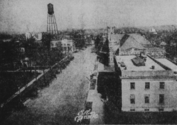
Textiles later became its chief industry during the 1920s, when production of cotton in Cleveland County rose from 8,000 to 80,000 bales a year. Cotton production peaked in 1948 with Cleveland County producing 83,549 bales, making it North Carolina's premier cotton county. In the 1930s, Shelby was known as "The Leading Shopping Center between Charlotte and Asheville". People from surrounding counties came to Shelby to shop, since there were numerous types of local and chain stores. By 1947, Shelby was a true thriving town with the mills paying among the highest wages in the South. In the 1950s, droughts, insect infestations, and government acreage controls resulted in the decline of cotton as Cleveland County's primary crop. [10]
Shelby was home to a group of political leaders in the first half of the 20th century, that have become known as the "Shelby Dynasty." These political leaders wielded power through the local, State and Federal governments. The most notable of Shelby's political leadership were brothers James L. Webb and Edwin Yates Webb and brothers-in-law O. Max Gardner and Clyde R. Hoey. As governors, NC representatives, and US congressman, the group impacted Shelby life and Shelby's reputation throughout the state. [11]
The architecture of Shelby is noteworthy in that despite being in a rural area, there are magnificent homes and buildings with unique character. Some buildings are county landmarks, such as the Historic Campbell Building and others are listed on the National Register of Historic Places: Banker's House, Joshua Beam House, Central Shelby Historic District, Cleveland County Courthouse, East Marion-Belvedere Park Historic District, James Heyward Hull House, Masonic Temple Building, Dr. Victor McBrayer House, George Sperling House and Outbuildings, Joseph Suttle House, Webbley, and West Warren Street Historic District. [12]
Shelby's community of art, music, and government all take place in Uptown Shelby historic district. Uptown Shelby is home to a large square, local businesses, and a variety of restaurants surrounding The Courthouse Square. Re-branded as "uptown" in the 70s to bring town-people back off the highway and away from the mall, this area has been named a "Main Street" by the National Trust for Historic Preservation.
The local pavilion hosts a twice-a-week Farmers Market on Wednesdays and Saturdays, as well as local concerts. Monthly summer festivals like Shelby Alive and Seventh Inning Stretch, hosted by the American Legion World Series, brings regional music acts to perform in the city. [13] With a low cost of living and a vibrant small town environment, Uptown Shelby has experienced a 10% growth in street level occupancy from 78% to 88%. [14] Uptown Shelby hosts opportunities for active living with groups that engage in cycling, running, crossfit, and yoga. Multiple restaurants and other local businesses are attracting day trippers and shoppers from across the region. Part of the city brand, live music is a part of community with the Earl Scruggs Center and the Don Gibson Theatre.
Other public attractions include walking trails like the thread trail and the Broad River Trail as well as public events. Reoccurring events include the Fall Livermush festival, The Cleveland County fair which is the largest county agricultural fair in North Carolina, The 7thinning Stretch, The Art of Sound, Arts on the Square, and various fundraisers. [15]
Shelby is known throughout the state for its collaborative methods between private, non-profit, and public sector organizations with groups like Leadership Cleveland County.
In 2011, Shelby was named the permanent home of the American Legion Baseball World Series after decades of rotating venues for the event. [16]
Shelby is located in south-central Cleveland County. U.S. Route 74, a four-lane highway, runs through the city south of the center, and leads east 21 miles (34 km) to Gastonia and west 27 miles (43 km) to Rutherfordton.
According to the United States Census Bureau, the city has a total area of 21.1 square miles (54.7 km2), of which 21.1 square miles (54.6 km2) is land and 0.04 square miles (0.1 km2), or 0.17%, is water. [17]
According to the Köppen Climate Classification system, Shelby has a humid subtropical climate, abbreviated "Cfa" on climate maps. The hottest temperature recorded in Shelby was 107 °F (41.7 °C) on July 30, 1952, while the coldest temperature recorded was −11 °F (−23.9 °C) on January 31, 1966. [18]
Climate data for Shelby, North Carolina, 1991–2020 normals, extremes 1893–present | |||||||||||||
---|---|---|---|---|---|---|---|---|---|---|---|---|---|
Month | Jan | Feb | Mar | Apr | May | Jun | Jul | Aug | Sep | Oct | Nov | Dec | Year |
Record high °F (°C) | 81 (27) | 82 (28) | 91 (33) | 93 (34) | 100 (38) | 105 (41) | 107 (42) | 105 (41) | 104 (40) | 98 (37) | 87 (31) | 80 (27) | 107 (42) |
Mean maximum °F (°C) | 69.8 (21.0) | 73.1 (22.8) | 80.4 (26.9) | 85.0 (29.4) | 89.4 (31.9) | 93.7 (34.3) | 96.1 (35.6) | 95.1 (35.1) | 92.1 (33.4) | 85.1 (29.5) | 77.1 (25.1) | 70.0 (21.1) | 97.2 (36.2) |
Mean daily maximum °F (°C) | 52.6 (11.4) | 56.5 (13.6) | 64.1 (17.8) | 73.1 (22.8) | 80.1 (26.7) | 87.1 (30.6) | 90.6 (32.6) | 88.9 (31.6) | 83.3 (28.5) | 73.9 (23.3) | 63.6 (17.6) | 55.1 (12.8) | 72.4 (22.4) |
Daily mean °F (°C) | 39.8 (4.3) | 43.0 (6.1) | 50.1 (10.1) | 58.8 (14.9) | 67.1 (19.5) | 74.6 (23.7) | 78.3 (25.7) | 76.8 (24.9) | 70.7 (21.5) | 59.5 (15.3) | 49.1 (9.5) | 42.2 (5.7) | 59.2 (15.1) |
Mean daily minimum °F (°C) | 26.9 (−2.8) | 29.5 (−1.4) | 36.0 (2.2) | 44.5 (6.9) | 54.0 (12.2) | 62.1 (16.7) | 65.9 (18.8) | 64.8 (18.2) | 58.1 (14.5) | 45.1 (7.3) | 34.6 (1.4) | 29.4 (−1.4) | 45.9 (7.7) |
Mean minimum °F (°C) | 11.7 (−11.3) | 16.4 (−8.7) | 20.4 (−6.4) | 30.1 (−1.1) | 38.9 (3.8) | 51.3 (10.7) | 58.9 (14.9) | 57.1 (13.9) | 46.0 (7.8) | 30.8 (−0.7) | 21.5 (−5.8) | 16.8 (−8.4) | 9.7 (−12.4) |
Record low °F (°C) | −11 (−24) | −9 (−23) | 5 (−15) | 20 (−7) | 29 (−2) | 37 (3) | 51 (11) | 48 (9) | 36 (2) | 19 (−7) | 11 (−12) | −2 (−19) | −11 (−24) |
Average precipitation inches (mm) | 4.31 (109) | 3.36 (85) | 4.68 (119) | 4.27 (108) | 4.30 (109) | 4.47 (114) | 4.41 (112) | 4.49 (114) | 3.98 (101) | 3.72 (94) | 3.98 (101) | 4.43 (113) | 50.40 (1,280) |
Average snowfall inches (cm) | 1.8 (4.6) | 0.6 (1.5) | 0.7 (1.8) | 0.0 (0.0) | 0.0 (0.0) | 0.0 (0.0) | 0.0 (0.0) | 0.0 (0.0) | 0.0 (0.0) | 0.0 (0.0) | 0.1 (0.25) | 0.8 (2.0) | 4.0 (10) |
Average precipitation days (≥ 0.01 in) | 9.9 | 8.7 | 10.2 | 9.1 | 10.5 | 10.9 | 11.8 | 11.2 | 7.9 | 7.8 | 8.1 | 9.7 | 115.8 |
Average snowy days (≥ 0.1 in) | 0.7 | 0.5 | 0.4 | 0.0 | 0.0 | 0.0 | 0.0 | 0.0 | 0.0 | 0.0 | 0.0 | 0.4 | 2.0 |
Source 1: NOAA [19] | |||||||||||||
Source 2: National Weather Service [18] |
Census | Pop. | Note | %± |
---|---|---|---|
1880 | 990 | — | |
1890 | 1,394 | 40.8% | |
1900 | 1,874 | 34.4% | |
1910 | 3,127 | 66.9% | |
1920 | 3,609 | 15.4% | |
1930 | 10,789 | 198.9% | |
1940 | 14,037 | 30.1% | |
1950 | 15,508 | 10.5% | |
1960 | 17,698 | 14.1% | |
1970 | 16,328 | −7.7% | |
1980 | 15,310 | −6.2% | |
1990 | 14,669 | −4.2% | |
2000 | 19,477 | 32.8% | |
2010 | 20,323 | 4.3% | |
2020 | 21,918 | 7.8% | |
U.S. Decennial Census [20] |
Race | Number | Percentage |
---|---|---|
White (non-Hispanic) | 11,169 | 50.96% |
Black or African American (non-Hispanic) | 8,383 | 38.25% |
Native American | 64 | 0.29% |
Asian | 228 | 1.04% |
Pacific Islander | 5 | 0.02% |
Other/Mixed | 947 | 4.32% |
Hispanic or Latino | 1,122 | 5.12% |
As of the 2020 United States census, there were 21,918 people, 8,013 households, and 4,887 families residing in the city.
As of the 2000 United States census, there were 19,477 people, 7,927 households, and 5,144 families residing in the city. [4] The population density was 1,073.8 inhabitants per square mile (414.6/km2). There were 8,853 housing units at an average density of 488.1 per square mile (188.5/km2). The racial makeup of the city was 56.88% White, 40.97% African American, 0.09% Native American, 0.56% Asian, 0.02% Pacific Islander, 0.72% from other races, and 0.76% from two or more races. Hispanic or Latino of any race were 1.56% of the population.
There were 7,927 households, out of which 27.7% had children under the age of 18 living with them, 41.3% were married couples living together, 20.0% had a female householder with no husband present, and 35.1% were non-families. 31.6% of all households were made up of individuals, and 15.1% had someone living alone who was 65 years of age or older. The average household size was 2.37 and the average family size was 2.97.
In the city, the population was spread out, with 25.0% under the age of 18, 7.6% from 18 to 24, 25.8% from 25 to 44, 21.8% from 45 to 64, and 19.7% who were 65 years of age or older. The median age was 39 years. For every 100 females, there were 83.2 males. For every 100 females age 18 and over, there were 75.8 males.
The median income for a household in the city was $29,345, and the median income for a family was $38,603. Males had a median income of $30,038 versus $21,362 for females. The per capita income for the city was $18,708. About 14.3% of families and 17.8% of the population were below the poverty line, including 26.7% of those under age 18 and 13.7% of those age 65 or over.
Shelby is served by US Highway 74 and its business route. US 74 Business travels through uptown Shelby along Marion St. and Warren St., giving travelers access to Shelby's growing central business district. Currently, a controlled-access highway (signed as US 74) is under construction from Mooresboro to Kings Mountain, which will bypass Shelby to the north. [22] Upon completion of the project, Charlotte and Asheville will be connected by virtually uninterrupted freeway via Interstate 85, US Highway 74, and Interstate 26.
Shelby is also served by four North Carolina State Highways.
Shelby-Cleveland County Regional Airport serves the city and county. The airport is used mostly for general aviation and is owned by the city of Shelby. Commercial air service is provided within a 2-hour drive at Charlotte (CLT), Asheville (AVL), Concord (USA) and Greenville/Spartanburg (GSP).
The 2004 film adaptation of Blood Done Sign My Name was filmed in Shelby [23] – as well as the reaping scene in the 2012 film adaptation of The Hunger Games , [24] and the 1982 slasher film Death Screams . [25]
A fictionalized version of the city is the setting of HBO comedy show Eastbound & Down . Filmed in Wilmington, North Carolina, it bears little geographic or cultural resemblance to the real place. Actor and writer Danny McBride chose the location as an inspiration because of its size, attitude, and name. [26]
The TV show Bizarre Foods with Andrew Zimmern visited the 2009 Livermush festival in Shelby. [27]
On November 11, 2007, the Oxygen Network's "Captured" aired a profile of The Brenda Sue Brown murder mystery that took place in Shelby in 1966. [28]
Lancaster County is a county located in the U.S. state of South Carolina. As of the 2020 census, its population was 96,016, Its county seat is Lancaster, which has an urban population of 23,979. The county was created in 1785.
Mecklenburg County is a county located in the southwestern region of the U.S. state of North Carolina, in the United States. As of the 2020 census, the population was 1,115,482, making it the second-most populous county in North Carolina, and the first county in the Carolinas to surpass one million in population. Its county seat is Charlotte, the state's largest municipality.
Gaston County is a county in the U.S. state of North Carolina. As of the 2020 census, the population was 227,943. The county seat is Gastonia. Dallas served as the original county seat from 1846 until 1911.
Cleveland County is a county located in the foothills of the Blue Ridge Mountains and the western Piedmont, on the southern border of the U.S. state of North Carolina. As of the 2020 census, the population was 99,519. Its county seat is Shelby. Cleveland County comprises the Shelby-Kings Mountain, NC Micropolitan Statistical Area, which is also included in the Charlotte-Concord, NC-SC Combined Statistical Area.
Boiling Springs is a town in Cleveland County, North Carolina, United States and is located in the westernmost part of the Charlotte metropolitan area, located approximately 50 miles away from the city. As of the 2010 census, the town's population was 4,647. It is home to Gardner–Webb University. The town is named after the natural spring found on the university's property, which feeds a small lake.
Grover is a town in Cleveland County, North Carolina, United States. The population was 708 at the 2010 census.
Polkville is a small town in Cleveland County, North Carolina, United States. The population was 545 at the 2010 census.
Havelock is a city in Craven County, North Carolina, United States. The population was 20,735 at the 2010 census. The city is home to Marine Corps Air Station Cherry Point, the world's largest Marine Corps air station, and home to the 2nd Marine Aircraft Wing.
Lexington is the county seat of Davidson County, North Carolina, United States. As of the 2020 census, the town had a population of 19,632. It is located in central North Carolina, 20 miles (32 km) south of Winston-Salem. Major highways include I-85, I-85B, U.S. Route 29, U.S. Route 70, U.S. Route 52 / I-285 and U.S. Route 64. Lexington is part of the Piedmont Triad region of the state.
Belmont is a small suburban city in Gaston County, North Carolina, United States, located about 9 miles (14 km) east of Gastonia. The population was 10,076 at the 2010 census. Once known as Garibaldi Station, it was named for the New York banker August Belmont. Belmont is home to Belmont Abbey College.
Dallas is a town in Gaston County, North Carolina, United States, and a suburb of Charlotte, located north of Gastonia. The population was 4,488 at the 2010 census. It was named for George M. Dallas, Vice President of the United States under James K. Polk.
Gastonia is the most populous city in and county seat of Gaston County, North Carolina, United States. It is the second-largest satellite city of the Charlotte area, behind Concord. The population was 80,411 in the 2020 census, up from 71,741 in 2010. Gastonia is the 13th-most populous city in North Carolina. It is part of the Charlotte-Concord-Gastonia, NC-SC Metropolitan Statistical Area, which is part of the Charlotte-Concord, NC-SC Combined Statistical Area.
Lowell is a small city in Gaston County, North Carolina, United States, located east of Gastonia. The population was 3,526 at the 2010 census.
Mount Holly is a small suburban city in northeastern Gaston County, North Carolina, United States. The city is situated just west of the Catawba River, north of Interstate 85, south of North Carolina State Highway 16. The population was 17,703 at the 2020 census, up from 13,656 in 2010.
Lincolnton is a city in Lincoln County, North Carolina, United States within the Charlotte metropolitan area. The population was 10,486 at the 2010 census. Lincolnton is northwest of Charlotte, on the South Fork of the Catawba River. The city is the county seat of Lincoln County.
Monroe is a city in and the county seat of Union County, North Carolina, United States. The population increased from 32,797 in 2010 to 34,551 in 2020. It is within the rapidly growing Charlotte metropolitan area. Monroe has a council-manager form of government.
Kings Mountain is a small suburban city within the Charlotte metropolitan area in Cleveland and Gaston counties, North Carolina, United States. Most of the city is in Cleveland County, with a small eastern portion in Gaston County. The population was 10,296 at the 2010 census.
The Charlotte metropolitan area, sometimes referred to as Metrolina, is a metropolitan area of the U.S. states of North and South Carolina, containing the city of Charlotte. The metropolitan area also includes the cities of Gastonia, Concord, Huntersville, and Rock Hill as well as the large suburban area in the counties surrounding Mecklenburg County, which is at the center of the metro area. Located in the Piedmont, it is the largest metropolitan area in the Carolinas, and the fourth largest in the Southeastern United States. The Charlotte metropolitan area is one of the fastest growing metropolitan areas in the United States.
Leroy Magnum McAfee was an American Confederate veteran and politician. He was a member of the North Carolina House of Representatives. He later served as the inspiration for the protagonist of his nephew Thomas Dixon Jr.'s infamous 1905 play The Clansman: A Historical Romance of the Ku Klux Klan and its 1915 film adaptation The Birth of a Nation.
The Cleveland County Courthouse is a courthouse building located at Shelby, Cleveland County, North Carolina.
The announcement that Thomas Dixon will erect a monument on the Shelby court square to the memory of Col. Leroy McAfee is hailed with delight.
Whether or no Thomas Dixon suspected that such a project would meet with spirited opposition all over his home county and as a piece of news, become circulated widely by newspapers of the South, is another matter but if Mr Dixon wants to stir up things and keep his name before the public to better advertise his productive "The Fall of a Nation", he could not have selected anything more timely. Mr Dixon proposed to erect this monument to Colonel McAfee in Shelby, the county seat of Cleveland County, where "Tommy" was "brought up" and to include a Ku Klux masque.