Belwood, North Carolina

Last updated

Belwood, North Carolina
Belwood-municipal-complex-nc.jpg
Belwood Community Center
NCMap-doton-Belwood.PNG
Location of Belwood, North Carolina
Coordinates: 35°28′46″N81°31′22″W / 35.47944°N 81.52278°W / 35.47944; -81.52278
Country United States
State North Carolina
County Cleveland
Area
[1]
  Total12.30 sq mi (31.87 km2)
  Land12.30 sq mi (31.85 km2)
  Water0.01 sq mi (0.02 km2)
Elevation
[2]
1,020 ft (310 m)
Population
 (2020)
  Total857
  Density69.69/sq mi (26.91/km2)
Time zone UTC-5 (Eastern (EST))
  Summer (DST) UTC-4 (EDT)
ZIP code
28090
Area code 704
FIPS code 37-04960 [3]
GNIS feature ID2405239 [2]

Belwood is a town in Cleveland County, North Carolina, United States. The population was 950 at the 2010 census. [4]

Contents

History

Belwood was incorporated in 1978. [5] The name of the town means "beautiful woods." [6]

Geography

Belwood is located in northeastern Cleveland County. The northeast border of the town follows the county line, with Lincoln County to the east.

North Carolina Highway 18 (Fallston Road) passes through the town, leading south 14 miles (23 km) to Shelby, the county seat, and north 25 miles (40 km) to Morganton.

According to the United States Census Bureau, Belwood has a total area of 12.3 square miles (31.9 km2), of which 0.008 square miles (0.02 km2), or 0.05%, is water. [4]

Demographics

Historical population
CensusPop.Note
1980 613
1990 6312.9%
2000 96252.5%
2010 950−1.2%
2020 857−9.8%
U.S. Decennial Census [7]

2020 census

Belwood racial composition [8]
RaceNumberPercentage
White (non-Hispanic)77790.67%
Black or African American (non-Hispanic)171.98%
Native American 20.23%
Asian 20.23%
Pacific Islander 20.23%
Other/Mixed 171.98%
Hispanic or Latino 404.67%

As of the 2020 United States census, there were 857 people, 349 households, and 251 families residing in the town.

2000 census

As of the census [3] of 2000, there were 962 people, 373 households, and 280 families residing in the town. The population density was 78.2 inhabitants per square mile (30.2/km2). There were 410 housing units at an average density of 33.3 per square mile (12.9/km2). The racial makeup of the town was 95.22% White, 3.85% African American, 0.10% Asian, 0.21% from other races, and 0.62% from two or more races. Hispanic or Latino of any race were 1.98% of the population.

There were 373 households, out of which 36.2% had children under the age of 18 living with them, 60.9% were married couples living together, 8.6% had a female householder with no husband present, and 24.7% were non-families. 22.3% of all households were made up of individuals, and 9.7% had someone living alone who was 65 years of age or older. The average household size was 2.58 and the average family size was 2.97.

In the town, the population was spread out, with 27.8% under the age of 18, 8.0% from 18 to 24, 28.8% from 25 to 44, 23.6% from 45 to 64, and 11.9% who were 65 years of age or older. The median age was 36 years. For every 100 females, there were 89.4 males. For every 100 females age 18 and over, there were 89.4 males.

The median income for a household in the town was $31,471, and the median income for a family was $40,417. Males had a median income of $30,139 versus $19,118 for females. The per capita income for the town was $14,323. About 9.5% of families and 13.2% of the population were below the poverty line, including 20.1% of those under the age of 18 and 7.9% of those aged 65 or over.

Related Research Articles

<span class="mw-page-title-main">Cleveland County, North Carolina</span> County in North Carolina, United States

Cleveland County is a county located in the foothills of the Blue Ridge Mountains and the western Piedmont, on the southern border of the U.S. state of North Carolina. As of the 2020 census, the population was 99,519. Its county seat is Shelby. Cleveland County comprises the Shelby, NC Micropolitan Statistical Area. It is included in the Charlotte-Concord, NC-SC Combined Statistical Area.

<span class="mw-page-title-main">Morristown, Indiana</span> Town in Indiana, United States

Morristown is a town in Hanover Township, Shelby County, in the U.S. state of Indiana. The population was 1,218 at the 2010 census.
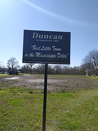
<span class="mw-page-title-main">Boiling Springs, North Carolina</span> Town in North Carolina, United States

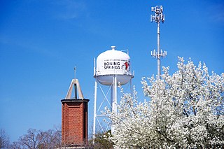
Boiling Springs is a town in Cleveland County, North Carolina, United States and is located in the westernmost part of the Charlotte metropolitan area, located approximately 50 miles away from the city. As of the 2010 census, the town's population was 4,647. It is home to Gardner–Webb University. The town is named after the natural spring found on the university's property, which feeds a small lake.

<span class="mw-page-title-main">Earl, North Carolina</span> Town in North Carolina, United States

Earl is a town in Cleveland County, North Carolina, United States. The population was 260 at the 2010 census.

<span class="mw-page-title-main">Fallston, North Carolina</span> Hamlet in North Carolina, United States

Fallston is a hamlet in Cleveland County, North Carolina, United States. The population was 607 at the 2010 census.

<span class="mw-page-title-main">Grover, North Carolina</span> Town in North Carolina, United States

Grover is a town in Cleveland County, North Carolina, United States. The population was 708 at the 2010 census.

<span class="mw-page-title-main">Kingstown, North Carolina</span> Town in North Carolina, United States

Kingstown is a town in Cleveland County, North Carolina, United States. The population was 681 at the 2010 census.

<span class="mw-page-title-main">Lattimore, North Carolina</span> Town in North Carolina, United States

Lattimore is a town in Cleveland County, North Carolina, United States. The population was 488 at the 2010 census.

<span class="mw-page-title-main">Lawndale, North Carolina</span> Town in North Carolina, United States

Lawndale is a town in Cleveland County, North Carolina, United States, situated along the First Broad River. The population was 606 at the 2010 census.

Light Oak is an unincorporated area and census-designated place (CDP) in Cleveland County, North Carolina, United States. The population was 691 at the 2010 census.

<span class="mw-page-title-main">Mooresboro, North Carolina</span> Town in North Carolina, United States

Mooresboro is a town in Cleveland County, North Carolina, United States. The population was 311 at the 2010 census.

<span class="mw-page-title-main">Polkville, North Carolina</span> Town in North Carolina, United States

Polkville is a small town in Cleveland County, North Carolina, United States. The population was 545 at the 2010 census.

<span class="mw-page-title-main">Shelby, North Carolina</span> City in North Carolina, United States

Shelby is a city in and the county seat of Cleveland County, North Carolina, United States. It lies near the western edge of the Charlotte combined statistical area. The population was 21,918 at the 2020 census.

<span class="mw-page-title-main">Waco, North Carolina</span> Town in North Carolina, United States

Waco is a town in Cleveland County, North Carolina, United States. The population was 321 at the 2010 census.

<span class="mw-page-title-main">Bayboro, North Carolina</span> Town in North Carolina, United States

Bayboro is a town in Pamlico County, North Carolina, United States. The population was 1,161 at the 2020 U.S. census. It is the county seat of Pamlico County.

<span class="mw-page-title-main">Columbus, North Carolina</span> Town in North Carolina, United States

Columbus is a town in Polk County, North Carolina, United States. The population was 999 at the 2010 census. It is the county seat of Polk County.

<span class="mw-page-title-main">Cleveland, North Carolina</span> Town in North Carolina, United States

Cleveland is a town in the Cleveland Township of Rowan County, North Carolina, United States. The population was 871 at the 2010 census.

<span class="mw-page-title-main">Kline, South Carolina</span> Town in South Carolina, United States

Kline is a town in Barnwell County, South Carolina, United States. The population was 197 at the 2010 census.

<span class="mw-page-title-main">Virgilina, Virginia</span> Town in Virginia, United States

Virgilina is a town in Halifax County, Virginia, United States. The population was 154 at the 2010 census. Virgilina was once a copper mining town. It was a stop on the Atlantic and Danville Railway as recently as the 1950s. It is named "Virgilina" because it is located on the Virginia and North Carolina border.

<span class="mw-page-title-main">Long View, North Carolina</span> Town in North Carolina, United States

Long View is a town in Burke and Catawba counties in the U.S. state of North Carolina. The population was 4,871 at the 2010 census. It is part of the Hickory–Lenoir–Morganton Metropolitan Statistical Area.

References

  1. "ArcGIS REST Services Directory". United States Census Bureau. Retrieved September 20, 2022.
  2. 1 2 U.S. Geological Survey Geographic Names Information System: Belwood, North Carolina
  3. 1 2 "U.S. Census website". United States Census Bureau . Retrieved January 31, 2008.
  4. 1 2 "Geographic Identifiers: 2010 Demographic Profile Data (G001): Belwood town, North Carolina". U.S. Census Bureau, American Factfinder. Archived from the original on February 12, 2020. Retrieved December 31, 2014.
  5. United States Census Bureau, Boundary and Annexation Survey, 1970-1979 , Vol. 3, p. 83.
  6. U.L. Patterson and Barry Hambright, Shelby and Cleveland County, North Carolina (Arcadia, 2000), p. 101.
  7. "Census of Population and Housing". Census.gov. Retrieved June 4, 2015.
  8. "Explore Census Data". data.census.gov. Retrieved December 21, 2021.