Casar, North Carolina

Last updated

Casar, North Carolina
NCMap-doton-Casar.PNG
Location of Casar, North Carolina
Coordinates: 35°30′45″N81°37′01″W / 35.51250°N 81.61694°W / 35.51250; -81.61694
Country United States
State North Carolina
County Cleveland
Area
[1]
  Total1.75 sq mi (4.53 km2)
  Land1.75 sq mi (4.53 km2)
  Water0.00 sq mi (0.00 km2)
Elevation
[2]
1,142 ft (348 m)
Population
 (2020)
  Total305
  Density174.29/sq mi (67.28/km2)
Time zone UTC-5 (Eastern (EST))
  Summer (DST) UTC-4 (EDT)
ZIP code
28020
Area code 704
FIPS code 37-10760 [3]
GNIS feature ID2406233 [2]

Casar is a small town in northern Cleveland County, North Carolina, United States. The population was 297 at the 2010 census.

Contents

Geography

According to the United States Census Bureau, the town has a total area of 1.8 square miles (4.7 km2), all land. According to locals, Casar was originally incorporated as Race Path in 1890. In 1903, the name was to be changed to Caesar, but Joe Meade with the US Postal Service sent off the application for incorporation, the name came back misspelled and the town officially became Casar.

Demographics

Historical population
CensusPop.Note
1970 339
1980 3462.1%
1990 328−5.2%
2000 308−6.1%
2010 297−3.6%
2020 3052.7%
U.S. Decennial Census [4]

As of the census [3] of 2000, there were 308 people, 132 households, and 93 families residing in the town. The population density was 176.0 inhabitants per square mile (68.0/km2). There were 145 housing units at an average density of 82.9 per square mile (32.0/km2). The racial makeup of the town was 99.35% White and 0.65% African American.

There were 132 households, out of which 25.0% had children under the age of 18 living with them, 55.3% were married couples living together, 7.6% had a female householder with no husband present, and 29.5% were non-families. 27.3% of all households were made up of individuals, and 10.6% had someone living alone who was 65 years of age or older. The average household size was 2.33 and the average family size was 2.81.

In the town, the population was spread out, with 19.2% under the age of 18, 7.5% from 18 to 24, 29.2% from 25 to 44, 25.3% from 45 to 64, and 18.8% who were 65 years of age or older. The median age was 40 years. For every 100 females, there were 94.9 males. For every 100 females age 18 and over, there were 91.5 males.

The median income for a household in the town was $26,875, and the median income for a family was $30,179. Males had a median income of $24,375 versus $16,250 for females. The per capita income for the town was $16,486. About 18.6% of families and 22.1% of the population were below the poverty line, including 31.4% of those under the age of eighteen and 13.2% of those 65 or over.

Related Research Articles

<span class="mw-page-title-main">Plainville, Indiana</span> Town in Indiana, United States

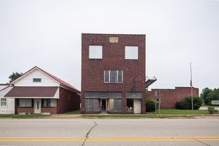
Plainville is a town in Steele Township, Daviess County, Indiana, United States. The population was 476 at the 2010 census. The former high school mascot was the Plainville Midgets.

<span class="mw-page-title-main">Spring Grove, Indiana</span> Town in Indiana, United States

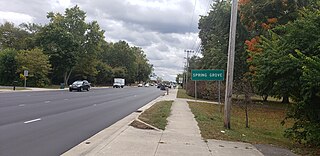
Spring Grove is a town in Wayne Township, Wayne County, in the U.S. state of Indiana. The population was 344 at the 2010 census.

<span class="mw-page-title-main">Stockholm, Maine</span> Town in the state of Maine, United States

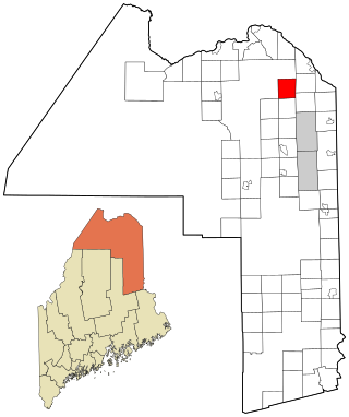
Stockholm is a town in Aroostook County, Maine, United States. The population was 250 at the 2020 census.

<span class="mw-page-title-main">Atkinson, Maine</span> Township in Maine, United States

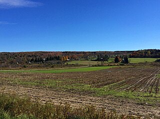
Atkinson is an unincorporated township and former town in Piscataquis County, Maine, United States, and part of the unorganized territory of Southeast Piscataquis, Maine. Its population was 326 at the 2010 census.

<span class="mw-page-title-main">Erhard, Minnesota</span> City in Minnesota, United States

Erhard is a city in Otter Tail County, Minnesota, United States. The population was 132 at the 2020 census.

<span class="mw-page-title-main">Hammond, Minnesota</span> City in Minnesota, United States

Hammond is a city in Wabasha County, Minnesota, United States. The population was 132 at the 2010 census.

<span class="mw-page-title-main">St. Marys Point, Minnesota</span> City in Minnesota, United States

St. Marys Point or Saint Marys Point is a city in Washington County, Minnesota, United States. The population was 353 at the 2020 census.

<span class="mw-page-title-main">Lewis and Clark Village, Missouri</span> Village in Missouri, United States

Lewis and Clark Village is a village in Buchanan County, Missouri, United States. The population was 96 at the 2020 census. It is part of the St. Joseph, MO–KS Metropolitan Statistical Area.

<span class="mw-page-title-main">Weston, Nebraska</span> Village in Saunder County, Nebraska, United States

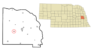
Weston is a village in Saunders County, Nebraska, United States. The population was 250 at the 2020 census.

<span class="mw-page-title-main">Allen, New York</span> Town in New York, United States

Allen is a town in Allegany County, New York, United States. The population was 493 at the 2020 census. The town is named after Ethan Allen.

<span class="mw-page-title-main">Cumberland, Ohio</span> Village in Guernsey County, Ohio, United States

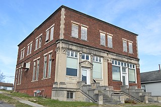
Cumberland is a village in Guernsey County, Ohio, United States. It is seventy miles east of Columbus. The population was 317 at the 2020 census.

<span class="mw-page-title-main">Gann, Ohio</span> Village in Ohio, United States

Brinkhaven, once known as Mount Holly and Gann, is a village in Knox County, Ohio, United States. The population was 114 at the 2020 census.

<span class="mw-page-title-main">Tarlton, Ohio</span> Village in Ohio, United States

Tarlton is a village in Fairfield and Pickaway counties in the U.S. state of Ohio. The population was 254 at the 2020 census.

<span class="mw-page-title-main">Dungannon, Virginia</span> Town in Virginia, United States

Dungannon is a town in Scott County, Virginia. The population was 257 at the 2020 census. It was named after the town of Dungannon in County Tyrone, Northern Ireland.

<span class="mw-page-title-main">Leon, West Virginia</span> Town in West Virginia, United States

Leon is a town in Mason County, West Virginia, United States, situated along the Kanawha River. The population was 137 at the 2020 census. It is part of the Point Pleasant, WV–OH Micropolitan Statistical Area.

<span class="mw-page-title-main">Ross, Wisconsin</span> Town in Wisconsin, United States

Ross is a town in Forest County, Wisconsin, United States. The population was 132 at the 2020 census. The census-designated place of Newald is located in the town.

<span class="mw-page-title-main">Kingston, Juneau County, Wisconsin</span> Town in Wisconsin, United States

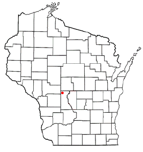
Kingston is a town in Juneau County, Wisconsin, United States. Its population was 58 at the 2000 census. The unincorporated communities of Mather and Meadow Valley are located in the town.

<span class="mw-page-title-main">Atlanta, Wisconsin</span> Town in Wisconsin, United States

Atlanta is a town in Rusk County, Wisconsin, United States. The population was 627 at the 2000 census. The unincorporated community of Imalone is located partially in the town.

Radisson is a town in Sawyer County, Wisconsin, United States. The population was 465 at the 2000 census. The Village of Radisson is located within the town.

Trempealeau is a town in Trempealeau County, Wisconsin, United States. The population was 1,618 at the 2000 census. The town surrounds the village of Trempealeau. The unincorporated communities of Centerville, West Prairie, and Wrights Corners are in the town.

References

  1. "ArcGIS REST Services Directory". United States Census Bureau. Retrieved September 20, 2022.
  2. 1 2 U.S. Geological Survey Geographic Names Information System: Casar, North Carolina
  3. 1 2 "U.S. Census website". United States Census Bureau . Retrieved January 31, 2008.
  4. "Census of Population and Housing". Census.gov. Retrieved June 4, 2015.