Patterson Springs, North Carolina

Last updated

Patterson Springs, North Carolina
Patterson-Springs-sign-nc.jpg
Welcome sign along S. Post Rd. (NC 180)
NCMap-doton-PattersonSprings.PNG
Location of Patterson Springs, North Carolina
Coordinates: 35°13′58″N81°30′58″W / 35.23278°N 81.51611°W / 35.23278; -81.51611
Country United States
State North Carolina
County Cleveland
Area
[1]
  Total1.03 sq mi (2.66 km2)
  Land1.03 sq mi (2.66 km2)
  Water0.00 sq mi (0.00 km2)
Elevation
[2]
906 ft (276 m)
Population
 (2020)
  Total571
  Density556.53/sq mi (214.81/km2)
Time zone UTC-5 (Eastern (EST))
  Summer (DST) UTC-4 (EDT)
ZIP code
28150
Area code 704
FIPS code 37-50700 [3]
GNIS feature ID2407081 [2]

Patterson Springs is a town in Cleveland County, North Carolina, United States. The population was 622 at the 2010 census.

Contents

History

Patterson Springs was originally a small farming community called "Swangs", with only a train depot and a post office. William George Patterson bought the land that held three springs from the "Epps" family. Patterson hoped that the supposed healing powers of these springs would help heal his son, Billy, who had poor health. Eventually, news of the supposed healing powers of these springs spread, and Patterson created a thirty to forty room resort to house travelers and merchants. The resort, which was one of several in the area, mainly attracted people from North Carolina, South Carolina, and Georgia. When the attendees of the resort were not at the springs, Patterson offered lawn bowling and a dance every Saturday night. In 1885, the name "Swangs confused the railroad people so they convinced the post office to change it to Patterson Springs and the government officials agreed. In 1915, a school building was created, housing all eleven(not 12) grades. Another was built in 1923, which housed grades one through eight, while the High School students attended No. 3 High School. In the 1960s, the post office closed, then in the 1970s, both schools closed. The train depot no longer exists. Most students now attend Township No. 3 Elementary School, Crest High School, or Pinnacle Classical Academy.

Geography

According to the United States Census Bureau, the town has a total area of 0.9 square miles (2.3 km2), all land.

The community is located at the southern end of conjoined state highways NC 180 and NC 226.

Demographics

Historical population
CensusPop.Note
1980 731
1990 690−5.6%
2000 620−10.1%
2010 6220.3%
2020 571−8.2%
U.S. Decennial Census [4]

As of the census [3] of 2000, there were 620 people, 254 households, and 169 families residing in the town. The population density was 682.1 inhabitants per square mile (263.4/km2). There were 272 housing units at an average density of 299.3 per square mile (115.6/km2). The racial makeup of the town was 95.48% White, 3.23% African American, 0.16% Native American, and 1.13% from two or more races. Hispanic or Latino of any race were 0.81% of the population.

There were 254 households, out of which 32.3% had children under the age of 18 living with them, 52.8% were married couples living together, 8.3% had a female householder with no husband present, and 33.1% were non-families. 24.8% of all households were made up of individuals, and 7.5% had someone living alone who was 65 years of age or older. The average household size was 2.44 and the average family size was 2.95.

In the town, the population was spread out, with 24.4% under the age of 18, 9.0% from 18 to 24, 33.5% from 25 to 44, 24.4% from 45 to 64, and 8.7% who were 65 years of age or older. The median age was 35 years. For every 100 females, there were 104.6 males. For every 100 females age 18 and over, there were 113.2 males.

The median income for a household in the town was $32,368, and the median income for a family was $34,500. Males had a median income of $31,591 versus $25,577 for females. The per capita income for the town was $15,092. About 10.4% of families and 16.5% of the population were below the poverty line, including 22.2% of those under age 18 and 2.6% of those age 65 or over.

Economy

Ticona, a German-based maker of polymers, operates a large facility in Patterson Springs, and is the town's major employer. Although the company labels the facility as being in Shelby, and the facility's postal mailing address is Shelby, the plant is actually located near Patterson Springs.

In the satirical TV show The Colbert Report, Stephen Colbert has repeatedly mentioned that he spent his early TV career days at the fictitious TV station WPTS, situated in Patterson Springs. This is usually accompanied by a video excerpt from his work there. [5]

Related Research Articles

<span class="mw-page-title-main">Talladega County, Alabama</span> County in Alabama, United States

Talladega County is one of the sixty-seven counties located in the east central portion of the U.S. state of Alabama. As of the 2020 census, the population was 82,149. Its county seat is Talladega.

<span class="mw-page-title-main">Cherokee, Alabama</span> Town in Alabama, United States

Cherokee is a town in west Colbert County, Alabama, United States. Located near the Tennessee River, it is part of the Florence–Muscle Shoals metropolitan area, known as "The Shoals". As of the 2010 census, the population of the town was 1,048.

<span class="mw-page-title-main">French Lick, Indiana</span> Town in Indiana, United States

French Lick is a town in French Lick Township, Orange County, Indiana. The population was 1,722 at the time of the 2020 census.

<span class="mw-page-title-main">Morristown, Indiana</span> Town in Indiana, United States

Morristown is a town in Hanover Township, Shelby County, in the U.S. state of Indiana. The population was 1,218 at the 2010 census.

<span class="mw-page-title-main">Shelby, Montana</span> City in Montana, United States

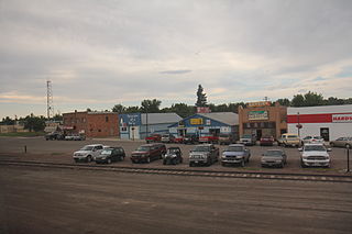
Shelby is a city in and the county seat of Toole County, Montana, United States. The population was 3,169 at the 2020 census.

<span class="mw-page-title-main">Ansonville, North Carolina</span> Town in North Carolina, United States

Ansonville is a town in Anson County, North Carolina, United States. The population was 440 at the 2020 census. The town has a total area of 1.5 square miles (3.8 km2), all land. It is located on the northern edge of Anson County, about a mile west of the Pee Dee River.

<span class="mw-page-title-main">Crossnore, North Carolina</span> Town in North Carolina, United States

Crossnore is a town in Avery County, North Carolina, United States. The population was 143 at the 2020 census.

<span class="mw-page-title-main">Connelly Springs, North Carolina</span> Town in North Carolina, United States

Connelly Springs is a town in Burke County, North Carolina, United States. The population was 1,669 at the 2010 census. It is part of the Hickory–Lenoir–Morganton Metropolitan Statistical Area.

<span class="mw-page-title-main">Belwood, North Carolina</span> Town in North Carolina, United States

Belwood is a town in Cleveland County, North Carolina, United States. The population was 950 at the 2010 census.

<span class="mw-page-title-main">Boiling Springs, North Carolina</span> Town in North Carolina, United States

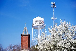
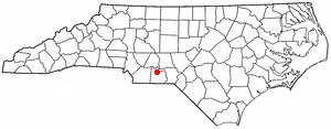
Boiling Springs is a town in Cleveland County, North Carolina, United States and is located in the westernmost part of the Charlotte metropolitan area, located approximately 50 miles away from the city. As of the 2010 census, the town's population was 4,647. It is home to Gardner–Webb University. The town is named after the natural spring found on the university's property, which feeds a small lake.

<span class="mw-page-title-main">Kingstown, North Carolina</span> Town in North Carolina, United States

Kingstown is a town in Cleveland County, North Carolina, United States. The population was 681 at the 2010 census.

<span class="mw-page-title-main">Lawndale, North Carolina</span> Town in North Carolina, United States

Lawndale is a town in Cleveland County, North Carolina, United States, situated along the First Broad River. The population was 606 at the 2010 census.

<span class="mw-page-title-main">Waco, North Carolina</span> Town in North Carolina, United States

Waco is a town in Cleveland County, North Carolina, United States. The population was 321 at the 2010 census.

<span class="mw-page-title-main">Seven Springs, North Carolina</span> Town in North Carolina, United States

Seven Springs is a town in Wayne County, North Carolina, United States. It lies next to the Neuse River. The 2012 population was estimated at 111. It is included in the Goldsboro, North Carolina Metropolitan Statistical Area.

<span class="mw-page-title-main">Shelby, Ohio</span> City in Ohio, United States

Shelby is a city in Richland County in the U.S. state of Ohio, northwest of the city of Mansfield. It is part of the Mansfield, Ohio Metropolitan Statistical Area. The population was 9,282 as of the 2020 census.

<span class="mw-page-title-main">Magnetic Springs, Ohio</span> Village in Ohio, United States

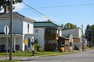
Magnetic Springs is a village in Leesburg Township, Union County, Ohio, United States. The population was 267 at the 2020 census. The village has a post office with the ZIP Code of 43036.

<span class="mw-page-title-main">Blackville, South Carolina</span> Town in South Carolina, United States

Blackville is a small town in Barnwell County, South Carolina, United States. The population was 2,406 at the 2010 census.

<span class="mw-page-title-main">Saratoga Springs, Utah</span> City in Utah, United States

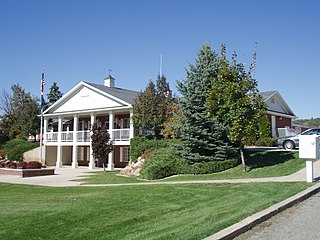
Saratoga Springs is a city in Utah County, Utah, United States. The elevation is 4,505 feet. It is part of the Provo–Orem, Utah Metropolitan Statistical Area. The city is a relatively new development along the northwestern shores of Utah Lake. It was incorporated on December 31, 1997 and has been growing rapidly since then. The population was 37,696 at the 2020 Census. Saratoga Springs became a city in 2001.

<span class="mw-page-title-main">Pleasant View, Utah</span> City in Utah, United States

Pleasant View is a city on the northern edge of Weber County, Utah, United States. The population was 7,979 at the 2010 census. It is part of the Ogden–Clearfield, Utah Metropolitan Statistical Area. It is a suburban community of Ogden.

<span class="mw-page-title-main">Seven Devils, North Carolina</span> Town in North Carolina, United States

Seven Devils is a town in Avery and Watauga counties in the U.S. state of North Carolina. The population was 313 at the 2020 census. The town, which is located in the Appalachian Mountains, is best known as the site of a popular wintertime tubing resort known as Hawksnest, which claims it has the largest tubing facility on the East Coast, and some of the town's year round residents earn their living at the resort. Many others are retirees. Developed in the 1970s as a vacation home community, Seven Devils is home mostly to seasonal residents.

References

  1. "ArcGIS REST Services Directory". United States Census Bureau. Retrieved September 20, 2022.
  2. 1 2 U.S. Geological Survey Geographic Names Information System: Patterson Springs, North Carolina
  3. 1 2 "U.S. Census website". United States Census Bureau . Retrieved January 31, 2008.
  4. "Census of Population and Housing". Census.gov. Retrieved June 4, 2015.
  5. "The Colbert Report | Comedy Central".