Polkville, North Carolina

Last updated

Polkville, North Carolina
Polkville-Town-Hall-nc.jpg
Town Hall
NCMap-doton-Polkville.PNG
Location of Polkville, North Carolina
Coordinates: 35°24′59″N81°38′38″W / 35.41639°N 81.64389°W / 35.41639; -81.64389
Country United States
State North Carolina
County Cleveland
Area
[1]
  Total1.86 sq mi (4.83 km2)
  Land1.86 sq mi (4.83 km2)
  Water0.00 sq mi (0.00 km2)
Elevation
[2]
1,083 ft (330 m)
Population
 (2020)
  Total516
  Density276.97/sq mi (106.94/km2)
Time zone UTC-5 (Eastern (EST))
  Summer (DST) UTC-4 (EDT)
ZIP code
28136
Area code 704
FIPS code 37-53160 [3]
GNIS feature ID2404545 [2]

Polkville is a small town in Cleveland County, North Carolina, United States. The population was 545 at the 2010 census. [4]

Contents

History

The John Lattimore House was listed on the National Register of Historic Places in 1982. [5]

Geography

Polkville is located in northwestern Cleveland County. North Carolina Highway 226 passes through the center of the town, leading southeast 12 miles (19 km) to Shelby and northwest over the South Mountains 31 miles (50 km) to Marion. North Carolina Highway 182 has its western terminus in Polkville at NC 226, and leads east 25 miles (40 km) to Lincolnton. North Carolina Highway 10 has its southwestern terminus in Polkville, leading northeast 36 miles (58 km) to Newton.

According to the United States Census Bureau, Polkville has a total area of 1.9 square miles (4.8 km2), all land. [4]

Demographics

Historical population
CensusPop.Note
1980 528
1990 1,514186.7%
2000 535−64.7%
2010 5451.9%
2020 516−5.3%
U.S. Decennial Census [6]

As of the census [3] of 2010, there were 545 people, 231 households, and 157 families residing in the city. The population density was 283.5 inhabitants per square mile (109.5/km2). There were 234 housing units at an average density of 124.0 per square mile (47.9/km2). The racial makeup of the city was 94.58% White, 3.74% African American, 0.75% from other races, and 0.93% from two or more races. Hispanic or Latino of any race were 2.24% of the population.

There were 214 households, out of which 32.7% had children under the age of 18 living with them, 57.5% were married couples living together, 12.1% had a female householder with no husband present, and 26.6% were non-families. 22.9% of all households were made up of individuals, and 10.3% had someone living alone who was 65 years of age or older. The average household size was 2.50 and the average family size was 2.94.

In the city, the population was spread out, with 26.0% under the age of 18, 6.9% from 18 to 24, 26.2% from 25 to 44, 26.0% from 45 to 64, and 15.0% who were 65 years of age or older. The median age was 38 years. For every 100 females, there were 83.2 males. For every 100 females age 18 and over, there were 84.2 males. [7]

The median income for a household in the city was $28,750, and the median income for a family was $40,875. Males had a median income of $26,797 versus $18,500 for females. The per capita income for the city was $15,015. About 16.3% of families and 19.1% of the population were below the poverty line, including 31.0% of those under age 18 and 18.5% of those age 65 or over.

Polkville Rodeo

The Polkville Rodeo is an annual event that takes place in the Mintz Arena at Polkville Baptist Church. This event is sanctioned by the International Professional Rodeo Association (IPRA) and is presented by F-K Rodeo Company of Charlotte. Advance tickets are available at local businesses as well as those sold at the gate. All proceeds go to benefit church members in their desires to participate in mission trips and disaster relief efforts.

Related Research Articles

<span class="mw-page-title-main">Newark, Arkansas</span> City in Arkansas, United States

Newark is a city in Independence County, Arkansas, United States. The population was 1,180 at the 2020 census.

<span class="mw-page-title-main">Edgewood, Iowa</span> City in Iowa, United States

Edgewood is a city in Clayton and Delaware counties in the U.S. state of Iowa. Highway 3, which runs through the center of town, is the dividing line between the two counties. The Edgewood post office was established in 1852 on the Clayton side of the town. Edgewood was formally incorporated in 1892, although it had a functioning council for some time before that date. The population was 909 at the time of the 2020 census, down from 923 in 2000.

<span class="mw-page-title-main">Dayton, Iowa</span> City in Iowa, United States

Dayton is a city in Webster County, Iowa, United States. The population was 772 at the time of the 2020 census.

<span class="mw-page-title-main">Effie, Minnesota</span> City in Minnesota, United States

Effie( EF-ee) is a city in Itasca County, Minnesota, United States. The population was 123 at the 2010 census.

<span class="mw-page-title-main">Morven, North Carolina</span> Town in North Carolina, United States

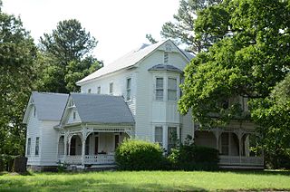
Morven is a town in Anson County, North Carolina, United States. The population was 335 at the 2020 census. The town was named after a town in Argyllshire, Scotland.

<span class="mw-page-title-main">Boiling Spring Lakes, North Carolina</span> City in North Carolina, United States

Boiling Spring Lakes is a city in Brunswick County, North Carolina, United States. The population was 5,943 at the 2020 census, up from 5,372 in 2010.

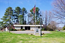
Northwest is a city in Brunswick County, North Carolina, United States. The population was 735 at the 2010 census. It is part of the Wilmington, NC Metropolitan Statistical Area.

<span class="mw-page-title-main">Avery Creek, North Carolina</span> Census-designated place in North Carolina, United States

Avery Creek is a census-designated place (CDP) in Buncombe County, North Carolina, United States. The population was 1,950 at the 2010 census. It is part of the Asheville Metropolitan Statistical Area.

<span class="mw-page-title-main">Mount Pleasant, North Carolina</span> Town in North Carolina, United States

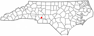
Mount Pleasant is a town located in eastern Cabarrus County, North Carolina, United States. As of the 2010 census, the town population was 1,652. The town center is located at the crossroads of Mount Pleasant Road and North Carolina Highway 73. NC Highway 49 skirts the town to the north on its way from Charlotte to Asheboro. The town is an important reference point along the road between Charlotte, the largest city in the Carolinas, and Raleigh, the North Carolina state capital. The town is also an important point on NC Highway 73 between Concord and Albemarle.

<span class="mw-page-title-main">Cape Carteret, North Carolina</span> Town in North Carolina, United States

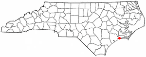
Cape Carteret is a town in Carteret County, on the southern coast of North Carolina, United States. It was incorporated in 1959 and had a population of 2,224 as of the 2020 census.

<span class="mw-page-title-main">Walkertown, North Carolina</span> Town in North Carolina, United States

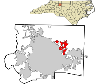
Walkertown is a town in Forsyth County, North Carolina, United States and a rural area outside of Winston-Salem. It is part of the Piedmont Triad. The population was 5,695 at the 2020 census.

<span class="mw-page-title-main">Williamston, North Carolina</span> Town in North Carolina, United States

Williamston is a town and the county seat of Martin County, North Carolina, United States. The population was 5,511 at the 2010 census. It is located in North Carolina's Inner Banks region. The closest major city is Greenville, approximately 28 mi to the southwest.

Eureka is a town in Wayne County, North Carolina, United States. The population was 197 at the 2010 census. It is included in the Goldsboro, North Carolina Metropolitan Statistical Area.

<span class="mw-page-title-main">Ehrhardt, South Carolina</span> Town in South Carolina, United States

Ehrhardt is a town in Bamberg County, South Carolina, United States. As of the 2010 census, the town population was 545.

Parker is a census-designated place (CDP) in Greenville County, South Carolina, United States. The population was 11,431 at the 2010 census, up from 10,760 in 2000. It is part of the Greenville–Mauldin–Easley Metropolitan Statistical Area.

<span class="mw-page-title-main">Loris, South Carolina</span> City in South Carolina, United States

Loris is a city in Horry County, South Carolina, United States. The population was 2,396 at the 2010 census, up from 2,079 in 2000.

<span class="mw-page-title-main">Gray Court, South Carolina</span> Town in South Carolina, United States

Gray Court is a town in Laurens County, South Carolina, United States. The population was 795 at the 2010 census. It is part of the Greenville–Mauldin–Easley Metropolitan Statistical Area.

<span class="mw-page-title-main">Clear Lake, South Dakota</span> City in South Dakota, United States

Clear Lake is a city in and the county seat of Deuel County, South Dakota, United States. The population was 1,218 at the 2020 census.

<span class="mw-page-title-main">Locust, North Carolina</span> City in North Carolina, United States

Locust is a small rural city in Stanly and Cabarrus counties in the U.S. state of North Carolina. The population was 2,930 at the 2010 census.

<span class="mw-page-title-main">Norwich (town), New York</span> Town in New York, United States

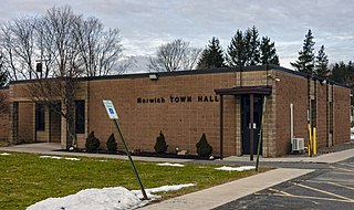
Norwich is a town in Chenango County, New York, United States. The population was 3,998 at the 2010 census.

References

  1. "ArcGIS REST Services Directory". United States Census Bureau. Retrieved September 20, 2022.
  2. 1 2 U.S. Geological Survey Geographic Names Information System: Polkville, North Carolina
  3. 1 2 "U.S. Census website". United States Census Bureau . Retrieved January 31, 2008.
  4. 1 2 "Geographic Identifiers: 2010 Demographic Profile Data (G001): Polkville city, North Carolina". U.S. Census Bureau, American Factfinder. Archived from the original on February 12, 2020. Retrieved December 30, 2014.
  5. "National Register Information System". National Register of Historic Places . National Park Service. July 9, 2010.
  6. "Census of Population and Housing". Census.gov. Retrieved June 4, 2015.
  7. United States Census: American factFinder: Profile of General Population and Housing Characteristics: 2010 Demographic Profile Data