Earl, North Carolina

Last updated

Earl, North Carolina
Earl-welcome-sign-nc.jpg
Welcome sign along Blacksburg Road (NC 198)
NCMap-doton-Earl.PNG
Location of Earl, North Carolina
Coordinates: 35°11′44″N81°32′03″W / 35.19556°N 81.53417°W / 35.19556; -81.53417
Country United States
State North Carolina
County Cleveland
Area
[1]
  Total0.86 sq mi (2.23 km2)
  Land0.86 sq mi (2.23 km2)
  Water0.00 sq mi (0.00 km2)
Elevation
[2]
840 ft (260 m)
Population
 (2020)
  Total198
  Density229.97/sq mi (88.76/km2)
Time zone UTC-5 (Eastern (EST))
  Summer (DST) UTC-4 (EDT)
ZIP code
28038
Area code 704
FIPS code 37-19140 [3]
GNIS feature ID2406410 [2]
Website http://www.townofearl.org/

Earl is a town in Cleveland County, North Carolina, United States. The population was 260 at the 2010 census.

Contents

History

Earl incorporated in 1889, and was named for local landowner Abel Earl. [4]

Geography

According to the United States Census Bureau, the town has a total area of 0.8 square miles (2.1 km2), all land.

Demographics

Historical population
CensusPop.Note
1980 206
1990 23011.7%
2000 2341.7%
2010 26011.1%
2020 198−23.8%
U.S. Decennial Census [5]

As of the census [3] of 2000, there were 234 people, 100 households, and 64 families residing in the town. The population density was 285.5 inhabitants per square mile (110.2/km2). There were 109 housing units at an average density of 133.0 per square mile (51.4/km2). The racial makeup of the town was 86.32% White, 11.97% African American, 0.85% from other races, and 0.85% from two or more races. Hispanic or Latino of any race were 2.56% of the population.

There were 100 households, out of which 25.0% had children under the age of 18 living with them, 41.0% were married couples living together, 17.0% had a female householder with no husband present, and 36.0% were non-families. 33.0% of all households were made up of individuals, and 9.0% had someone living alone who was 65 years of age or older. The average household size was 2.34 and the average family size was 2.97.

In the town, the population was spread out, with 24.8% under the age of 18, 9.0% from 18 to 24, 29.9% from 25 to 44, 27.4% from 45 to 64, and 9.0% who were 65 years of age or older. The median age was 35 years. For every 100 females, there were 84.3 males. For every 100 females age 18 and over, there were 89.2 males.

The median income for a household in the town was $30,625, and the median income for a family was $35,714. Males had a median income of $27,292 versus $19,318 for females. The per capita income for the town was $17,016. About 7.6% of families and 10.8% of the population were below the poverty line, including 27.5% of those under the age of eighteen and 13.6% of those 65 or over.

Related Research Articles

<span class="mw-page-title-main">Morven, North Carolina</span> Town in North Carolina, United States

Morven is a town in Anson County, North Carolina, United States. The population was 329 at the 2020 census. The town was named after a town in Argyllshire, Scotland.

<span class="mw-page-title-main">White Lake, North Carolina</span> Town in North Carolina, United States

White Lake is a town in Bladen County, North Carolina, United States. The population was 802 at the 2010 census, up from 529 in 2000.

<span class="mw-page-title-main">Indian Beach, North Carolina</span> Town in North Carolina, United States

Indian Beach is a town in Carteret County, North Carolina, United States. The population was 223 as of the 2020 census.

<span class="mw-page-title-main">Casar, North Carolina</span> Town in North Carolina, United States

Casar is a small town in northern Cleveland County, North Carolina, United States. The population was 297 at the 2010 census.

<span class="mw-page-title-main">Fallston, North Carolina</span> Hamlet in North Carolina, United States

Fallston is a hamlet in Cleveland County, North Carolina, United States. The population was 607 at the 2010 census.

<span class="mw-page-title-main">Lawndale, North Carolina</span> Town in North Carolina, United States

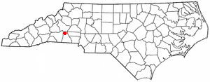
Lawndale is a town in Cleveland County, North Carolina, United States, situated along the First Broad River. The population was 606 at the 2010 census.

Boardman is a town in Columbus County, North Carolina, United States. Per the 2020 census, the population was 166.

<span class="mw-page-title-main">Trent Woods, North Carolina</span> Town in North Carolina, United States

Trent Woods is a town in Craven County, North Carolina, United States. The population was 4,155 in 2010. It is part of the New Bern, North Carolina Metropolitan Statistical Area.

<span class="mw-page-title-main">Speed, North Carolina</span> Town in North Carolina, United States

Speed is a town in Edgecombe County, North Carolina, United States. It is part of the Rocky Mount, North Carolina Metropolitan Statistical Area. The population was 80 at the 2010 census.

<span class="mw-page-title-main">Hassell, North Carolina</span> Town in North Carolina, United States

Hassell is a town in Martin County, North Carolina, United States. The population was 84 at the 2010 census.

<span class="mw-page-title-main">Bayboro, North Carolina</span> Town in North Carolina, United States

Bayboro is a town in Pamlico County, North Carolina, United States. The population was 1,161 at the 2020 U.S. census. It is the county seat of Pamlico County.

<span class="mw-page-title-main">Mesic, North Carolina</span> Town in North Carolina, United States

Mesic is a town in Pamlico County, North Carolina, United States. The population was 220 at the 2010 census. It is part of the New Bern, North Carolina Micropolitan Statistical Area.

<span class="mw-page-title-main">Minnesott Beach, North Carolina</span> Town in North Carolina, United States

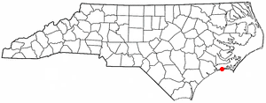
Minnesott Beach is a town in Pamlico County, North Carolina, United States. The population was 440 at the 2010 census. It is part of the New Bern, North Carolina Metropolitan Statistical Area.

<span class="mw-page-title-main">Stonewall, North Carolina</span> Town in North Carolina, United States

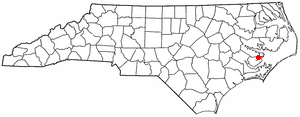
Stonewall is a town in Pamlico County, North Carolina, United States. The population was 281 at the 2010 census. It is part of the New Bern, North Carolina Micropolitan Statistical Area.

<span class="mw-page-title-main">Fountain, North Carolina</span> Town in North Carolina, United States

Fountain is a town in Pitt County, North Carolina, United States. The population was 427 at the 2010 census. The town is a part of the Greenville Metropolitan Area located in North Carolina's Inner Banks region.

<span class="mw-page-title-main">Staley, North Carolina</span> Town in North Carolina, United States

Staley is a town in Randolph County, North Carolina, United States. The population was 393 at the 2010 census.

<span class="mw-page-title-main">Macon, North Carolina</span> Town in North Carolina, United States

Macon is a town located in Warren County, North Carolina, United States. As of the 2010 census, the town had a total population of 119. It is named for Nathaniel Macon, long-time Speaker of the U.S. House of Representatives.

<span class="mw-page-title-main">Hilda, South Carolina</span> Town in South Carolina, United States

Hilda is a town in Barnwell County, South Carolina, United States. The population was 447 at the 2010 census..

<span class="mw-page-title-main">Sharpsburg, North Carolina</span> Town in North Carolina, United States

Sharpsburg is a town in Edgecombe, Nash, and Wilson counties, North Carolina, United States. It is part of the Rocky Mount, North Carolina Metropolitan Statistical Area. The population was 2,024 at the 2010 Census.

<span class="mw-page-title-main">Weddington, North Carolina</span> Town in North Carolina, United States

Weddington is a suburban town in Union County, North Carolina, United States. The population was 9,459 at the 2010 census. It is a suburb in the Charlotte metropolitan area. The current mayor of Weddington is Jim Bell.

References

  1. "ArcGIS REST Services Directory". United States Census Bureau. Retrieved September 20, 2022.
  2. 1 2 U.S. Geological Survey Geographic Names Information System: Earl, North Carolina
  3. 1 2 "U.S. Census website". United States Census Bureau . Retrieved January 31, 2008.
  4. William S. Powell and Michael Hill, North Carolina Gazetteer (University of North Carolina Press, 2010). Accessed at NCPedia.org.
  5. "Census of Population and Housing". Census.gov. Retrieved June 4, 2015.